The remains of the Castle can be visited
FortressAl-Karak
Kerak ((الكرك Castle
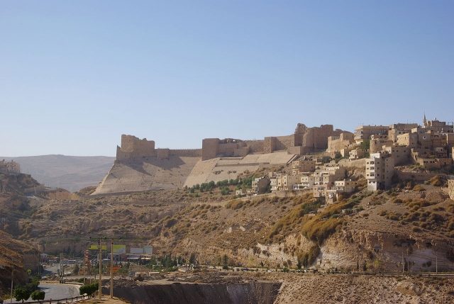
The fortress ruin of Kerak, also known as Crac des Moabites, is an impressive testament to the Crusader era in present-day Jordan. It is perched on a rocky outcrop and was once a strategically important point, controlling trade routes and the surrounding region. Its architecture combines European, Byzantine, and Arabic influences.
History+
The history of the site of Kerak dates back a long way, with settlements since the Iron Age and significance as a city of the Moabites and Nabataeans. In 105, the Romans conquered the site from the Nabataeans. Under Byzantine rule, Kerak was an episcopal see and largely retained its Christian character under the Arabs. Construction of the Crusader castle began in 1142 under Paganus, King Fulk's seneschal, and it became the center of the Lordship of Oultrejordain. Later, from 1176, the castle came into the possession of Raynald of Châtillon, who attacked caravans from here and even planned an assault on Mecca. This provoked a siege by Saladin in 1183, which was lifted by King Baldwin IV. Another siege in 1184 also failed. After the Battle of Hattin in 1187, Saladin besieged Kerak again and finally captured the fortress in 1188 after eight months. Under the Ayyubids and Mamluks, Kerak continued to serve as a regional seat of power.
Location+
The fortress ruin of Kerak is located in Al-Karak, in the Karak district in the southern region of Jordan. It lies at an altitude of approximately 1004 meters above sea level.
On site+
Today, the fortress ruin of Kerak is accessible to visitors and can be explored. It is a significant example of Crusader architecture.
Nearby+
- Roman fort Khirbet el-Fityan (Ancient Buildings), approx. 16.3 km away
- Roman fort Betthorus (Ancient Buildings), approx. 17.1 km away
- Masada Fortress (מצדה) (Ancient Buildings), approx. 36.4 km away
- Hatzeva Fortress (Fortress), approx. 59.9 km away
Take Mobile History with you
You are reading this text for free. Premium adds what matters on the road: descriptions read aloud, sites found through your camera, whole regions taken offline.
- Every description, including the ~17,700 Premium sites
- Audio guide: have descriptions read to you on location
- AR finder: see sites through your camera, with distance and bearing
- Unlimited saved sites
14 days free, then from €2.99 a month. Cancel anytime.
Source: Wikipedia · Licence: CC BY-SA 4.0 · Image: http://de.wikipedia.org/wiki/Datei:Kerak_BW_1.JPG
This description draws on the facts documented in the linked Wikipedia article; Wikipedia content is licensed under CC BY-SA 4.0. Wording and editing: Mobile History.
Location: 31.1806, 35.7014