To be privately owned
CastleLangenfeld-Reusrath
Dückeburg Castle
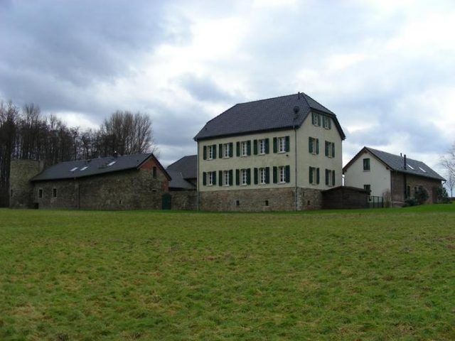
The Dückeburg is a listed former moated castle in Langenfeld-Reusrath (North Rhine-Westphalia). The Dückeburg is located on Reusrather Straße, slightly north of the intersection with Alte Schulstraße at the Dückeburg crossroads. Reusrather Straße was formerly an important connection between Immigrath and Reusrath. It ran parallel to the Mauspfad (along today's Opladener Straße), the oldest, regionally significant trade route through the Rhineland, which connected the Rheingau in the south with the Hellweg in Essen. To the east of the Dückeburg lies the Further Moor with the localities of Furth and Hapelrath. To the south, Reusrath adjoins, to the west Galkhausen and to the north Immigrath. The former lowland castle is now surrounded by fields and meadows, but to the north and east at only a short distance from the Galkhauser Wald, which is traversed by the Galkhauser Bach.
Name+
As with the other settlements in Langenfeld, the interpretations of the name, here "dücke", are diverse. Suggestions range from the "thick" castle to a "crouching" (hidden) castle to a derivation from Middle High German "dugen" or "diuken". The former can be translated as "to sink", the latter as "to press" or "to push", which led to the conjecture that the Dückeburg was the successor to the legendary "sunken castle" in Hapelrath. If this assumption were true, a predecessor building could have already borne this name, namely the archaeological monument Motte Flachenhof in Immigrath.
The Dückeburg is first mentioned in a document in 1444 as Duckenburch. The first owners were the Lords of Zobbe and von Sieberg. A Johann Pieck von Sieberg made part of his fortune by trading in bricks, of which he is said to have sold entire ship loads to Cologne. They were followed from 1466 for more than 200 years by the Lords of Etzbach. This period also includes the pledging of the inheritance share in the Dückeburg by a Wilhelm von Etzbach on November 26, 1524. The von Etzbachs were followed by the Lords Spies von Büllesheim.
In 1795, the castle was destroyed by fire due to wartime effects during the invasion of French troops. The former castle complex was then rebuilt as a manor house on the old foundations. The two-story residential building has a half-hipped roof, a grand staircase dominates the courtyard and the adjoining farm buildings. The gate is located between pillars in the middle of the wall enclosing the courtyard. From the mid-19th century (Müller mentions the year 1829), the estate was owned by the Counts Mirbach zu Harff and subsequently by their heirs, the Lords zu Loudon-Vorst-Gudenau.
In 1816, the Dückeburg is listed as a former knight's seat in a table of place names with nine inhabitants.
After extensive monument-appropriate renovation between 2002 and 2004, the farm complex is now in private hands. During the measures, the mix of styles from different centuries was retained. However, a restoration of the moats, which were still present 100 years ago, and which, towards the northwest, were a stately 55 paces wide, surrounded by a 1.5-meter high and up to four-meter wide rampart, was dispensed with. Presumably related hydraulic engineering measures in the forest towards Trompeter Straße are still awaiting closer investigation as possible archaeological monuments.
Historical Mentions+
Vicarage in Reusrath
According to a list from 1578, in the Honnschaft Reusrath, the owners of the Dückeburg bore the main share of the costs of a vicarage at St. Barbara's Church. The then owners, the von Etzbach family, provided a "heusgen, hoef, garden, lant und 1 morgen heuwais" (small house, farm, garden, land and 1 morgen of hay meadow), totaling about four morgen of land. However, the von Etzbach family did not have the sole right to fill the vicarage, the population had to be involved.
From the Time of the Reformation
During the Reformation, there was an eager struggle between Lutherans and Calvinists in Reusrath. Many citizens of Reusrath were close to the Lutherans, only a few to the Calvinists. This minority also included the bailiff of Monheim and "resident of Dickhenburg", Johann von Etzbach, who promised Lutheran preachers but appointed Reformed ones, thereby causing great difficulties for them and the entire population.
The Dückeburg Hunting Ground
In 1670, the Dückeburg hunter Hansen on the Weyerhof zu Hapelrath, now a deserted settlement, was questioned under oath about the Dückeburg hunting ground. He stated the Wupper river as the southern border, the Rhine as the western border, the Rothenberger Hof as the eastern border, the hamlet of Furth, Gladbach without the Leichlinger Sandberge, but then Rupelrath and Gosse, along Ohligser Straße to Ossenbruch, in the north Schwanenmühle and Rietherbach up to the "Gericht" (court), then back towards Immigrath and from there in a roughly straight line via Ganspohl, Stevenshoven south past Knipprather Wald to the Rhine.
The "Diebstraß" to Monheim
The border road of the Dückeburg hunting area from Ganspohl south past Stevenshoven and Knipprath to the Rhine was called the "Diebstraß" (Thieves' Road). This name can still be found on a map by the cartographer LeCoq from 1805. Whether it was connected to the gallows at the "Galgendriesch" (Gallows Meadow) or to the unfreedom of the Langenfelders towards the Monheim office (i.e., something like the theft of freedom), remains unknown. However, the administration of Langenfeld from Monheim was never a one-way street: With Johann and Bernhard von Etzbach, the Dückeburg provided two Monheim bailiffs. From April 15, 1814, to September 30, 1851, Monheim was conversely administered from Richrath. The name "Diebstraß" for the connection to Monheim has long since disappeared.
The Earning Power of the Estate from 1824
According to a Prussian law from 1824, so-called "altlandtagsfähige Güter" (estates eligible for the old provincial parliament) paid a principal land tax of 75 Reichstalers or more. In the Solingen district, there were twelve such estates. According to information from District Administrator Hauer from 1932, the Dückeburg ranked last, and the moated castle Haus Graven sixth. Nevertheless, both, unlike, for example, the former knight's seat Langfort in today's Langfort, were still listed as profitable farms.
Take Mobile History with you
You are reading this text for free. Premium adds what matters on the road: descriptions read aloud, sites found through your camera, whole regions taken offline.
- Every description, including the ~17,700 Premium sites
- Audio guide: have descriptions read to you on location
- AR finder: see sites through your camera, with distance and bearing
- Unlimited saved sites
14 days free, then from €2.99 a month. Cancel anytime.
Source: Wikipedia · Licence: CC BY-SA 4.0 · Image: http://www.wehrbauten.de/thread.php?threadid=583
This description draws on the facts documented in the linked Wikipedia article; Wikipedia content is licensed under CC BY-SA 4.0. Wording and editing: Mobile History.
Location: 51.0953, 6.9746