Local Authorities
CastleHuriel
Donjon de la Toque
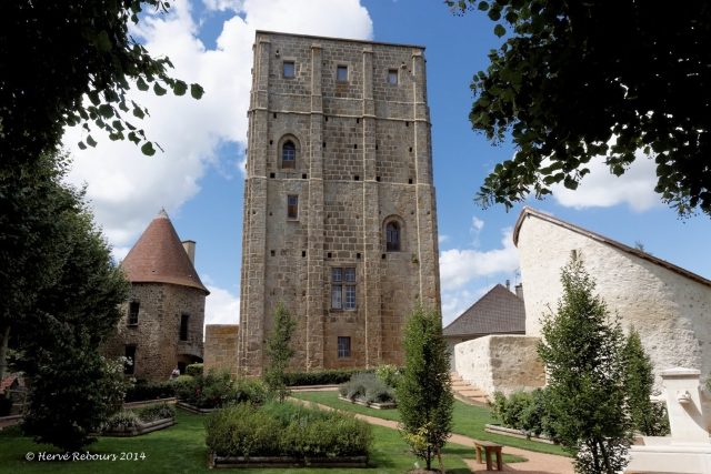
The Donjon de la Toque is an imposing keep located in the municipality of Huriel in the heart of France. As the last remaining part of what was once a larger castle complex, it bears witness to Romanesque architecture and continues to shape the local landscape.
History+
The Donjon de la Toque was built between the late 11th and late 12th centuries by the Humbaud family. Modifications to the upper sections took place in the 13th century, and in the 16th century, comfort improvements such as fireplaces and mullioned windows were added. The lordship of Huriel initially belonged to the Humbaults, later to the House of Déols. Through marriage, it passed to the de Brosse family around 1265. In 1478, Jean II de Brosse sold the complex to Jean de Bourgogne, Count of Nevers. Subsequently, the Barony of Huriel changed hands several times, including the Hurault de Cheverny and Jehannot de Bartillat families, before the municipality acquired the castle in 1879. The keep and its surrounding wall were classified as historical monuments in 1886 and benefited from extensive restoration, which was completed in 2023.
Location+
The Donjon de la Toque is situated in the center of the municipality of Huriel in the Allier department, Auvergne region, France. Its elevation is approximately 329 meters above sea level.
On site+
Today, the keep is used by local authorities. It houses a museum dedicated to the history of the lords of Huriel and the town's viticultural past.
Nearby+
- Château de Bien-Assis (castle), approx. 8.2 km away
- Château des Étourneaux (château), approx. 8.5 km away
- Château de la Crête (castle), approx. 10.3 km away
- Château des ducs de Bourbon (castle), approx. 10.3 km away
Take Mobile History with you
You are reading this text for free. Premium adds what matters on the road: descriptions read aloud, sites found through your camera, whole regions taken offline.
- Every description, including the ~17,700 Premium sites
- Audio guide: have descriptions read to you on location
- AR finder: see sites through your camera, with distance and bearing
- Unlimited saved sites
14 days free, then from €2.99 a month. Cancel anytime.
Source: Wikipedia · Licence: CC BY-SA 4.0 · Image: Hervé Rebours
This description draws on the facts documented in the linked Wikipedia article; Wikipedia content is licensed under CC BY-SA 4.0. Wording and editing: Mobile History.
Location: 46.3731, 2.4786