Protestant Dean Front Odenwald
CastleGroß-Umstadt
Darmstädter Castle
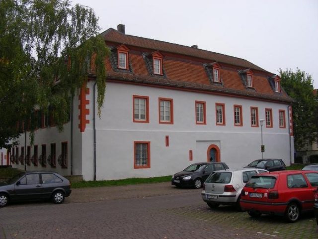
Darmstadt Castle (also known as Hanau Castle or Unterschloss) is located in the northeast of the town of Groß-Umstadt in the Darmstadt-Dieburg district in Hesse and is a noble residence that emerged from a former moated castle, which was expanded into a residential castle in the late Middle Ages. It is one of the town's formerly seven noble residences. In the Middle Ages, the castle was a defensive stronghold securing the eastern access to the town via Pferdsbach (also called Mühlbach here) and the town moat, directly situated on the town wall. Today, alongside the town hall, it marks the eastern access to the old town.
The former castle was probably built as early as the 12th century on behalf of Fulda Abbey, the owner of the town of Umstadt (Omestat majoris). The castle served as the official seat of the Fulda vogts and later feudal lords, the County of Katzenelnbogen and the House of Münzenberg, who already managed to acquire the castle as allodial property. Umstadt was administered as a condominium. The Münzenberg fief was taken over by the Hanauers after their extinction in the male line in 1255: an inheritance fell to Reinhard I of Hanau, who was married to Adelheid of Münzenberg (Münzenberg inheritance). The Katzenelnbogen rule was displaced.
In 1374, the monastery also pledged the other half of the town to Hanau, but in 1390 sold the town completely to the Palatinate. Hanau thus received its half as a Palatinate fief instead of a Fulda fief. It only became legally effective in 1427, after the Palatinate finally paid the purchase price. In 1376, it was first mentioned (on the occasion of disputes with the House of Wertheim) as a moated castle. From here, the Hanauers ruled their half of the town.
In 1458, Anna of Lichtenberg and Philipp I the Elder "consummated" their marriage in the castle. It can be assumed that the Umstadt fief was now also assigned to the County of Hanau-Lichtenberg. The castle was rebuilt and extended in the Gothic style from 1460.
Until 1504, it was inhabited by the Hanauers under Philipp III of Hanau-Lichtenberg. In the Bavarian Feud from 1504 to 1521, the town and castle were conquered by the Hessian Landgrave Wilhelm II and, after a settlement in 1524, finally passed to the Landgraviate of Hesse under Philipp I. Philipp III of Hanau-Lichtenberg was compensated with a payment of 16,000 fl in 1521 and the rule over the tithe villages of Langstadt and Kleestadt. The castle became the official seat of the Hessian Landgraves.
Until 1530, Johann von Löwenstein was the pledged bailiff in Umstadt. It was not until 1538 that Landgrave Philipp of Hesse found a new pledged bailiff in Otto von Boineburg zu Felsberg and Gerstungen.
In the mid-18th century, the castle was completely rebuilt as a Baroque palace. After 1787, it still housed the official secretariat and registry.
Building History+
Built as a moated castle, more precise construction data are only available from Matthäus Merian's copper engraving around 1645. At that time, the castle consisted of a tall and mighty four-story defensive tower, which was directly attached to the town wall. It was equipped with four small two-story corner towers and had a pointed roof, with each side probably having a dormer. The tower was flanked by a house with a stepped gable on both sides. The smaller tower behind it (northwest) (only house height) was the gate tower to the town wall and the castle access. In 1640, the still existing keep or residential tower (palas) was demolished due to dilapidation. The presence of the economic building is naturally assumed.
From 1727 to 1747, the former castle was completely redesigned in a representative manner and converted into a Baroque three-wing complex. None of the old buildings have been preserved. To the north, the complex ends with the town wall, which is now much lower and can still be seen for about seventy meters with small interruptions. The lower floor of the north wing (facing the town hall), which faces east towards the street Am Darmstädter Schloss, was formerly a direct part of the town wall.
How the castle was rebuilt can be seen on the floor plan by surveyor Balthasar Blum from 1787: the tower and palas from the original construction no longer exist (cf. Merian's picture). Whether the building of the official scribe, which now stands in its place, consists of rebuilt or newly constructed remains, can no longer be verified. The official secretariat was also demolished in the 20th century. Through the westward two-winged courtyard gate, one entered the large inner courtyard, the "Vorderster Hofblatz mitsamt dem Mistblatz" (B). To the north adjoined the west wing (Building IV), the so-called Kelterhaus (wine press house). It also contained the bailiff's residence. Further north, framed by a part of the town wall, lay the baroque garden (A) in the French style. It could only be entered via the forecourt (D), which also provided access to the other castle wings. The official secretariat (Building II) separated the garden and the forecourt. Next to it was the two-story washhouse (Building III), which was directly attached to the northern town wall. As a right-angled ensemble, the north and south wings (Building I) were grouped around the forecourt. To the south of it was the vegetable garden as part of the large inner courtyard. On the eastern town wall was the stable (Building V) and to the south the tithe barn (Building VI) with two small pigsties (*) in front of it. The southern end of the large inner courtyard was the two-story granary, called the Long House (Building VII). The structure and purpose of Buildings VIII to X are unknown, but they probably served supply or residential purposes for the servants. The courtyard gate was framed to the south by the large pigsty. All roofs were characterized as hip roofs. The wide longitudinal buildings, the south wing and the Long House, determined the overall impression.
Since the mid-20th century, only the restored north and south wings with a passage remain. Both are united under a mansard roof. The north wing has one floor on a high plinth, while the south wing is two-story. The third wing, which in turn connected perpendicularly to the west wing and gave the entire ensemble its S-shaped floor plan, was demolished in 1952. In its place today stands the memorial with a menorah in memory of the old synagogue and behind it the stele with the list of all (Groß-)Umstadt Jews who fell victim to the Holocaust between 1933 and 1945. Only parts of the former forecourt now belong to the castle ensemble. The garden became part of the retirement and senior citizens' home now located there.
The castle was extensively restored in 1974 and transferred to state ownership.
Current Use+
The castle belonged to the State of Hesse, which transferred its use to the Evangelical Church in Hesse and Nassau. The Evangelical Deanery Vorderer Odenwald, with the dean and the deanery youth office, is located in the south wing. The Ecumenical Hospice Association Groß-Umstadt and the Groß-Umstadt branch of the Diakonisches Werk Darmstadt-Dieburg are also located there. From the rooms in the south wing, Radio Weinwelle now broadcasts annually for the Groß-Umstadt Wine Festival.
Around 2010, the castle was sold and is now in private hands. It has been extensively renovated and restored in recent years. The inner courtyard, enclosed by the castle wings, has been exemplarily restored. The usage agreements with the EKHN are being continued.
Take Mobile History with you
You are reading this text for free. Premium adds what matters on the road: descriptions read aloud, sites found through your camera, whole regions taken offline.
- Every description, including the ~17,700 Premium sites
- Audio guide: have descriptions read to you on location
- AR finder: see sites through your camera, with distance and bearing
- Unlimited saved sites
14 days free, then from €2.99 a month. Cancel anytime.
Source: Wikipedia · Licence: CC BY-SA 4.0 · Image: http://www.wehrbauten.de/thread.php?threadid=971
This description draws on the facts documented in the linked Wikipedia article; Wikipedia content is licensed under CC BY-SA 4.0. Wording and editing: Mobile History.
Location: 49.8696, 8.9297