The Roman Castle can be visited
Ancient BuildingAhegg
Roman Castle Ahegg
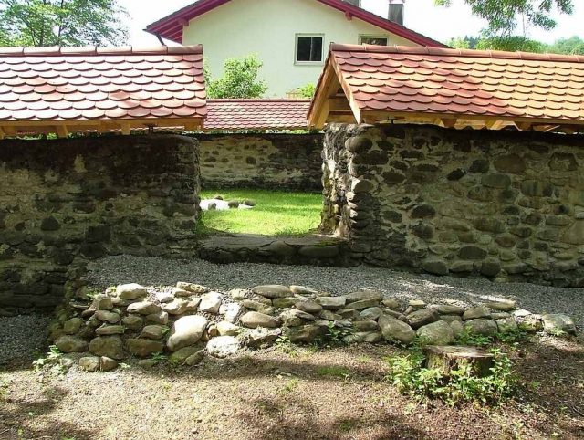
The Burgus Ahegg is a small Roman military outpost that served as a late antique residential and watchtower for controlling a section of the imperial border along the Danube-Iller-Rhine Limes (DIR). The excavated remains of the complex, which are open to visitors, are located in the Ahegg district of the market town of Buchenberg in the Oberallgäu district of Bavaria. It is the only one of its kind in Southern Germany of which remains are still visible above ground.
Between the Bregenz fort (Brigantium) on the eastern shore of Lake Constance and the late antique garrison on Kempten's Burghalde (Cambodunum) lay the so-called "dry border" of the DIR Limes, which was not secured by a river. The Burgus Ahegg was founded for strategic reasons on the Adelegg ridge, formed by a moraine, and was thus off the Roman Limes road. The elevated location of the Burgus allowed the garrison to survey the surrounding borderland far and wide. The nearest significant Roman intervention forces on the Limes were five kilometers northeast above the Iller near Kempten and to the west in the Tetrarchic cavalry fort of Vemania near Isny in the Allgäu, which had been built at the foot of an Adelegg spur.
Research History+
The Burgus in Ahegg, which lay under a large mound of rubble until its excavation, was excavated in 1932 by the Bavarian State Office for Monument Preservation (BLfD). However, the Roman origin of this complex was still considered "uncertain" by archaeologist Wilhelm Schleiermacher (1904–1977) in 1972. The building remains have been improperly renovated several times since their excavation, using non-frost-resistant mortar. It was not until 1995 that employees of Kempten's city archaeology carried out a restoration using a special mortar. After further securing measures undertaken by the archaeological working group of the Buchenberg Local History Association, a brick-covered wooden gable roof was placed on the preserved wall stumps in 2009/2010 to protect them from further decay.
Construction History+
Towards the end of the 3rd century, the decades-long insecure situation along many border sections of the Roman Empire stabilized. Forts were newly built, renewed, or rebuilt. Numerous wooden watchtowers were erected between these garrison sites. Examples from the Upper Rhine and from the Roman road between Augusta Vindelicorum (Augsburg) and Cambodunum (Kempten) can be dated to the reign of Emperor Constantine (306–337). In Ahegg, too, there are indications that the later stone Burgus was preceded by a wooden predecessor.
After devastating Germanic invasions, Emperor Valentinian I (364–375) launched a building program of larger and smaller fortifications (castra et castella) along the imperial borders on the Rhine (Rhenus) and Danube (Danuvius) to ensure the security of the empire. From 369 onwards, a multitude of stone structures were built on the Upper Rhine (province of Maxima Sequanorum) on the long-distance connection Brigantium – Cambodunum – Caelius Mons, as well as on the upper and middle Danube. The design of many of the Burgi built at that time followed a largely standardized construction scheme. Thus, many structural details known from Ahegg are also known from other sites. The very well-preserved Burgus Bacharnsdorf in Lower Austria also shows the rising masonry up to the 2nd floor. For the late antique province of Raetia II, to which Ahegg belonged, no datable inscription for the Burgi has yet been discovered, but many very similar structures on the Danube Limes could be assigned to the Valentinian phase through stratifiable coins, brick stamps, and – to a much lesser extent – building inscriptions (e.g., the Burgi Visegrád-Lepence and Visegrád-Steinbruch).
The walls of the Ahegg Burgus, set in mortar, still preserved to a height of about 1.5 meters and 1.2 meters thick during the excavation, consist of rolled stones, as found on the bed of the Rottach directly east of the site. The fortification forms an almost square enclosure of 10.8 x 11.0 meters, with a 1.45 m wide gate opening on its north side. A post setting was found in the middle of the Burgus. These posts once supported the mighty roof. A fireplace made of brick slabs was found on the east side. During the renovation work in 2009, it was discovered that a drainage system made of large river pebbles had been laid directly around the Burgus, which disposed of wastewater in Roman times. As an approach obstacle, the fortification was protected by a ditch, still recognizable today, and the steeply sloping ravine towards the Rottach.
In particular, the recovered pottery, such as grinding bowls with internal glaze, is typical of many late antique military sites and settlements. Glazed ware first appears in finds from both the Germanic provinces and Pannonia around 320 AD and can be traced in Raetia – as at the Künzing (Quintana) site – until the late 5th century.
A permanent guard of about a dozen men, subordinate to one of the nearest forts, can be assumed for the Burgus. The layers of fire in the Burgus, which cannot be precisely dated, have been attributed to the late 4th or early 5th century AD and bear witness to the end of Roman rule in the pre-Alpine region.
Post-Roman Development+
The massive Roman wall remains, which perhaps still stood upright in the later Middle Ages, were probably reused by the builders of a small castle and converted for the new purpose. This was indicated by the medieval rubble that overlay the ancient findings during the excavation. In contrast, archaeologist Paul Reinecke (1872–1958) assumed that the small castle, probably built towards the end of the High Middle Ages, was founded on the Burgus, which had already fallen into a mound of rubble. This new complex has been linked by research to the Ahegg Castle mentioned in the "Martinszeller Vertrag" in 1525.
Take Mobile History with you
You are reading this text for free. Premium adds what matters on the road: descriptions read aloud, sites found through your camera, whole regions taken offline.
- Every description, including the ~17,700 Premium sites
- Audio guide: have descriptions read to you on location
- AR finder: see sites through your camera, with distance and bearing
- Unlimited saved sites
14 days free, then from €2.99 a month. Cancel anytime.
Source: Wikipedia · Licence: CC BY-SA 4.0
This description draws on the facts documented in the linked Wikipedia article; Wikipedia content is licensed under CC BY-SA 4.0. Wording and editing: Mobile History.
Location: 47.7098, 10.2502