The remains of the Castle can be visited
RuinWildpoldsried
Wolkenberg Castle
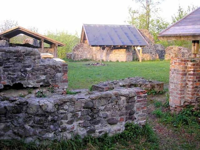
Wolkenberg Castle is a medieval castle ruin. It is located in the Kempten Forest near the municipality of Wildpoldsried in the Oberallgäu district in Swabia. The high to post-medieval castle complex was excavated and secured at the end of the 20th century.
In the 12th and 13th centuries, Wolkenberg was considered a ministerialis castle of the Welfs and Staufer. This is evidenced by a report from 1262, according to which the knight Albert von Wolkenberg testified against Duke Konradin of Swabia in Constance. The first documented mention of Albert von Wolkenberg, however, dates from 1278, when he attested to the rights of the Princely Abbey of Kempten to the possessions in the Kempten Forest. Although the finances of the Lords of Wolkenberg were not bad, they sold the castle to the Lords of Rotenstein at the end of the 13th century.
Konrad von Rothenstein, the son, inherited the castle from his father in 1339 and was forced to sell it to Ulrich von Diessen as early as 1344. Immediately thereafter, Knight Konrad von Rothenstein killed a citizen of the city of Kempten, thus making himself guilty of breaking the public peace. In response, the Kempteners then conquered the "still" residence of Knight Konrad, captured him, and ultimately beheaded him.
Ulrich von Diessen also gained sad notoriety in 1356 by killing the first freely elected mayor of the city of Kempten. He himself was later murdered by Knight Hainz the Elder of Rauns-Fischen. Due to lack of assets, his sons Hans and Ulrich von Diessen reached a settlement in 1391 for the sawmill and the upper mill near Wildpoldsried. As early as 1392, the sale of the Vogt tax and Vogt rights followed. In 1398, the castle and the village of Wildpoldsried were incorporated into the Princely Abbey of Kempten. The Princely Abbey of Kempten had the castle administered by Heinrich von Diessen until 1409.
In 1404, Knight Heinrich von Schellenberg launched an attempt to conquer Wolkenberg Castle from the nearby Wagegg Castle. The attackers were discovered during the reconnaissance of the terrain and were captured.
From 1417 to 1642, Wolkenberg served as the official seat of a vogtei (bailiwick) of the Abbot of Kempten. In addition to jurisdiction over the subordinate abbey land, the Vogt also collected the due taxes in his area. In 1460, Jörg Beck's father was imprisoned in the dungeon. He led the Appenzellers into the Battle of Buchenberg on March 14, in which the abbey Vogt Walther von Hohenegg lost his life.
Until 1470, the Chapel of St. Cyprian in Wildpoldsried served as the castle's place of worship. With the construction of its own chapel and the appointment of a chaplain, Wolkenberg had its own small church from that year on. Parts of the Wolkenberg altar are now in the local history museum of the city of Kempten.
Under Jörg Knopf von Leubas, the castle was conquered and burned down by peasants in April 1525. After its reconstruction in 1557, the bourgeois Vogt Jörg Albrecht Bader resided on the hill of Wolkenberg. In 1632, the citizens and peasants of Kempten once again burned down the castle. A makeshift reconstruction of the burned walls followed. After its abandonment as a vogtei in 1642, the Swiss Paul Delle took up residence in Wolkenberg. 53 years later, after the fire of the associated brewery, the castle was finally left to decay.
In 1979, the excavation of the sparse remains of the ruin began. After the reconstruction of the existing wall remains by employees of the Kempten Forestry Office, the ruin was handed over to the public in 1987 as a valuable historical monument. The Burgfreunde Wolkenberg e.V. association, founded in 2002, is committed to the preservation of the Wolkenberg castle ruin.
Description+
The castle ruin is located about 1500 meters southeast of Wildpoldsried on the rectangular plateau of a pre-Alpine hill (829 m above sea level) above today's federal highway 12. The castle site is well protected on all sides by relatively steep slopes.
The castle path leads past the site of the former farmstead (memorial stone) over the southeastern flank of the main castle cone steeply into the castle courtyard. On Nessler's plan (1985), the entire southern part of the ruin was still missing. Since the excavation and restoration measures at the end of the 20th century, the foundation remains can also be traced here several meters high.
Next to the main gate in the southeast stood a mighty square keep with a wall thickness of up to four meters. The entire northern part of the castle was occupied by a large main building (palas). In the middle of the courtyard facade, a round stair tower provided access to the upper floors. On the ground floor, two polygonal column stumps indicate a vaulted hall (Dürnitz). The castle's baking oven was uncovered at the northwest edge.
The curtain wall of the castle can be traced almost around the entire castle plateau again since the renovation. The masonry consists mainly of coarse, relatively small rolled and broken stones. The extensions of the 15th/16th centuries were partly executed in brick construction (Dürnitz, baking oven). The preserved or supplemented wall sections are still up to four meters high and are partly protected by modern roofs.
Overall, the castle presents the typical picture of a smaller high medieval (Staufer period) hilltop castle. The foundations of the curtain wall, the palas, and the keep are clearly recognizable as classic structural elements. Due to its elevated position about 100 meters above the valley, the castle site was well defensible even without the construction of elaborate ditch systems.
Take Mobile History with you
You are reading this text for free. Premium adds what matters on the road: descriptions read aloud, sites found through your camera, whole regions taken offline.
- Every description, including the ~17,700 Premium sites
- Audio guide: have descriptions read to you on location
- AR finder: see sites through your camera, with distance and bearing
- Unlimited saved sites
14 days free, then from €2.99 a month. Cancel anytime.
Source: Wikipedia · Licence: CC BY-SA 4.0
This description draws on the facts documented in the linked Wikipedia article; Wikipedia content is licensed under CC BY-SA 4.0. Wording and editing: Mobile History.
Location: 47.7552, 10.4162