The remains of the Castle can be visited
RuinZusmarshausen - Steinekirch
Wolfsberg Castle
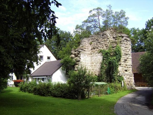
Wolfsberg Castle is the ruin of a hilltop castle above the Zusmarshausen district of Steinekirch (Augsburg district, Swabia) on a wooded hill. The earthworks and remains of the large keep from the High Middle Ages have been preserved.
The castle probably originated in the 10th century as the seat of the Lords Fraß, who allegedly distinguished themselves particularly in the Battle of Lechfeld (955). This ministerial family of the Bishops of Augsburg later named themselves "von Wolfsperch" (1233) after the castle and bore a wolf in their coat of arms.
In 1292, a Heinrich Fraß von Wolfsberg (Hainrich Frayß von Wolfsperg, ministerialis ecclesie Augustensis) witnessed the peace treaty between Bishop Wolfhart and Duke Ludwig of Bavaria. In 1333, Ulrich Fraß is mentioned as a guarantor in the sale of Zusameck Castle to the Prince-Bishopric of Augsburg.
Around 1350, the Fraß family disappears from written sources. The Schwelcher family appears as successors at the fortress. In 1374, Wieland (Wielant der Swaelher) and in 1382, Ulrich Schwelcher are mentioned with the epithet "von Wolfsberg". The family originally came from the ministerialis of the Dukes of Teck.
The new lords of the castle are said to have committed several attacks on trade routes. The castle was located not far from the road between Augsburg and Ulm. The Wolfsberg was subsequently besieged several times in vain by troops from the imperial city of Augsburg. Even during the "City War" in December 1388, when the Dukes of Bavaria devastated the Augsburg area, the Augsburg troops had to withdraw due to bad weather.
In 1390, Wieland der Schwelcher sold the Wolfsberg to the Dukes. The castle was then pledged to Friedrich von Freyberg (documented in 1394 and 1396). In 1434, the pledge was held by the brothers Ulrich and Hans Nördlinger of Augsburg.
As a result of the warlike conflicts during the "Imperial War" between Duke Ludwig the Rich of Bavaria-Landshut and Emperor Frederick III, Augsburg mercenaries under Wilhelm von Rechberg destroyed the ducal Wolfsberg Castle on January 26, 1462. The castle was subsequently abandoned.
In 1508, the Dukes of Bavaria sold the lordship of Steinekirch for 6000 guilders to Philipp von Stain zu Jettingen. In 1589, the guardianship of Marquard von Stain passed the property to the Augsburg Cathedral Chapter. The Cathedral Chapter held the lordship until secularization in 1803.
Around 1852, the castle ruins were exploited as a quarry for the construction of the Augsburg-Ulm railway line. Until then, larger wall remains of the castle complex are said to have still stood. The ruin of the keep remained largely untouched at that time, as it had belonged to the historical association of Swabia since 1836.
The agricultural properties on the main and outer bailey plateaus date back to the 19th and 20th centuries. After the Second World War, a modern residential building was built next to the keep. The castle area is freely accessible, but the inside of the tower is on private property.
Description+
The large castle complex is located at an altitude of approximately 525 meters on the eastern ridge of the Zusam valley above Steinekirch. The main and outer bailey are separated by a neck ditch 7 to 8 meters deep. East of the core work was the spacious outer bailey, whose approximately four-meter-deep neck ditch in the access area was largely filled in. The ditch continues to the south and ends at a semicircular slope plateau. To the west is another terrain step in front of the main castle. The northern outer ditch, whose mighty rampart documents the early medieval origin of the castle, can still be clearly traced in the terrain.
These ramparts are also found around the irregularly rectangular main castle plateau (approx. 25 x 50 meters). The ditch depths here are up to five meters. The terrain slopes steeply into the valley to the south and west.
The ramparts were investigated in 1973 during a rescue excavation (Otto Schneider). Apparently, a berm had originally been laid out about 10 meters below the castle plateau, which was only fortified by palisades. The post holes of this fortification could be documented. Later, the ramparts were piled up on this berm. Six successive construction phases could be identified here. Numerous sandstone boulders in the soil indicate a stone ring wall.
Some brick wall sections of the main castle's ring wall can still be identified, whose stone dimensions (approx. 35 x 16 x 7 cm) suggest an origin in the 14th century.
The Keep The mighty remains of the keep probably date back to the 12th century. The large tower is today the only stone testimony to early knightly culture in the entire district of Augsburg. Particularly noteworthy is the enormous wall thickness of the ground floor, which is about four meters. The masonry consists of large Nagelfluh ashlar blocks (length approx. 0.60–1.10 meters, height approx. 0.50 meters), some of which were designed as bossed ashlar with a marginal draft.
The mighty tower was built in the typical shell construction method. The space between the inner and outer shell was filled with mortar, which is interspersed with rubble and pebbles (cast masonry).
The north side is about 12.30 meters long, the west side up to 7 meters, the east side is still preserved to a length of about 3.80 meters. The lower stone layers are designed as a plinth. Inside, a wall step is visible in the upper third. Here in the interior, the ashlar blocks are smoothly finished, beam holes indicate the floor division. The former keep is still about 11 meters high.
Despite its partial demolition in the 19th century, one of the most important High Medieval keeps in Southern Bavaria has been preserved here, which, however, has so far received little attention from academic castle research.
Take Mobile History with you
You are reading this text for free. Premium adds what matters on the road: descriptions read aloud, sites found through your camera, whole regions taken offline.
- Every description, including the ~17,700 Premium sites
- Audio guide: have descriptions read to you on location
- AR finder: see sites through your camera, with distance and bearing
- Unlimited saved sites
14 days free, then from €2.99 a month. Cancel anytime.
Source: Wikipedia · Licence: CC BY-SA 4.0 · Image: hubi1802
This description draws on the facts documented in the linked Wikipedia article; Wikipedia content is licensed under CC BY-SA 4.0. Wording and editing: Mobile History.
Location: 48.3714, 10.5844