The remains of the castle can be visited
CastleWernstein am Inn
Wimberg Castle
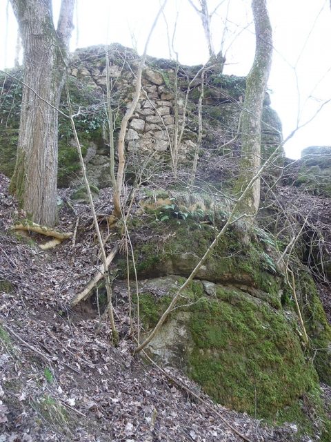
The castle ruin Wimberg, also known as Neuhauser Burgstall, is a ruin of a fortification of undetermined age on the Austrian bank of the Inn river at the entrance to the Vornbach Narrows. It is located in the municipality of Wernstein am Inn in the district of Schärding in Upper Austria.
The Neuhauser Burgstall was a fortification that blocked off extensive plateaus and is therefore referred to as a "plateau-edge castle". The complex can be dated to the late Early Middle Ages (9th-10th century). Similar structures can be found in neighboring Lower Bavaria. Around 1880, the pastor and archaeologist Johann Ev. Lamprecht recorded the dimensions of this fortification in a sketch plan. In his description of the fortification, Lamprecht reports that it was an outpost of Neuburg am Inn Castle. He also provides a temporal classification, stating that the complex was still well preserved and guarded by its own castle keepers in the 15th century and fell into disrepair from the 16th century onwards. Finds from the castle hill (key, spearhead, iron ball) also suggest the use of the complex in the late Middle Ages.
In local castle literature, the fortification is mentioned as Wimberg Castle. Norbert Grabherr (1976), like Lamprecht, assumes this castle was part of a chain of fortifications of Neuburg am Inn Castle on the now Austrian side of the Inn. It is said to have stood on a prominent rock outcrop near the Inn. As evidence, reference is made to a Heinricus de Wineberge, who is mentioned around 1230.
According to Hille (1975), Wimberg is named after Eppo von Wimberg from the Vormbach family. He was married in his second marriage to the widow and heiress of Waltenstein. In the 11th and 12th centuries, Wimberg is said to have been in the possession of the brothers Ulrich and Hermann von Vormbach, and around 1100, a Count Hermann I von Windberg is mentioned, whose wife also came from the Vormbach family. The castle is said to have been inhabited by their sister Luitgard, who was married to Askurin von Bogen. Two children (Berchtold and Albert I) sprang from this marriage.
According to more recent research, however, the assignment of the fortification to a noble family mentioned in documents is not clearly possible.
In the 20th century, parts of the fortification area fell victim to the advancing quarry operations of the Kapsreiter company. Today, the quarry is disused.
Name+
The original name of the fortification cannot be determined with certainty due to the lack of clearly assignable documents. The name Wimberg comes from the village of the same name, located just under 1 km to the east, while the name Neuhauser Burgstall is derived from the Neuhauser farm (Wimberg No. 5), located 300 m to the southwest.
Description+
The core of the fortification today lies hard on the edge of the former quarry's drop-off and is separated from the eastern hinterland by an outer and an inner semicircular ditch. Lamprecht mentions another, outer ditch, which was largely leveled by agricultural use and is covered with meadows. No trace of this third ditch remains today.
The castle hill itself consists of mighty natural granite blocks. Only on the east side of the core work are sparse remains of walls preserved.
Take Mobile History with you
You are reading this text for free. Premium adds what matters on the road: descriptions read aloud, sites found through your camera, whole regions taken offline.
- Every description, including the ~17,700 Premium sites
- Audio guide: have descriptions read to you on location
- AR finder: see sites through your camera, with distance and bearing
- Unlimited saved sites
14 days free, then from €2.99 a month. Cancel anytime.
Source: Wikipedia · Licence: CC BY-SA 4.0 · Image: http://commons.wikimedia.org/wiki/File:Wimberg_Burgh%C3%BCgel_Mauerreste.JPG
This description draws on the facts documented in the linked Wikipedia article; Wikipedia content is licensed under CC BY-SA 4.0. Wording and editing: Mobile History.
Location: 48.4983, 13.4520