The remains of the Castle can be visited
CastleVirneburg
Virneburg Castle
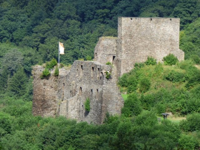
The Virneburg castle ruin is the ruin of a hill castle on a 430 m above sea level slate hill, surrounded by the Nitzbach stream, above the municipality of the same name in the Mayen-Koblenz district in Rhineland-Palatinate.
The castle was probably built in the second half of the 12th century as a palatine fief. The first mention of the castle is found in a document from 1192, in which the brothers Gottfried and Friedrich von Virneburg assigned their castle "Vernenburgh" along with the county and all its appurtenances to Archbishop Johann I of Trier as a fief. This original document is not preserved; the 16th-century copy is either an erroneous transcription or a forgery due to the formulations contained therein, which were not yet common around 1200.
The Lords of Virneburg, later elevated to counts, are first mentioned in 1042 in a document by Archbishop Poppo of Trier with "Bernhardus de Virneburch". At that time, the feudal suzerainty had passed to the Counts of Sayn, but Johann von Sayn ceded it back to the Palatine Counts in 1358, with the exception of the castle, which was still referred to as a male fief of the Counts of Sayn in 1506, although the Counts of Virneburg no longer recognized their feudal suzerainty.
In 1339, Count Ruprecht von Virneburg gave part of the castle as a fief to Elector Balduin of Trier in exchange for the remission of a debt, and the "hoechste thurn" (highest tower), probably the old keep from the time of construction, is mentioned for the first time.
In 1414, the Counts of Virneburg also had to hand over the rest of the castle to Archbishop Werner von Falkenstein, for whom the county had always been a thorn in his side. However, only a few years later, the Virneburgers managed to redeem their castle from the Trier pledge. With the death of Count Kuno von Virneburg in 1545, the Virneburg line died out.
The heirs were the Counts of der Mark-Arenberg, later the castle and county came to the Counts of Manderscheid-Blankenheim, were shortly thereafter seized by Trier as an expired fief, but after an objection by the Counts of Manderscheid-Schleiden, it was returned to them as a fief in 1549. Through them, the property passed to Löwenstein-Wertheim in 1600.
An inventory of the castle made at that time lists twelve rooms. The keep was renewed and received a new battlement in 1623, but already in 1663 the castle was described as very dilapidated, especially "on the side towards the high walls and well". A repair was postponed at that time, and in 1665 the walls in the front and upper castle courtyard were "completely fallen down and completely ruined". In 1670, the dilapidated keep was demolished and rebuilt the following year. The dilapidated curtain wall was repaired and the most necessary construction work was carried out in the castle.
When the French invaded the Eifel, the castle complex was blown up in 1689, the tower was completely destroyed, the residential buildings went up in flames, and the curtain wall was razed.
At the instigation of the Royal District Court of Adenau, the castle ruin was publicly sold on January 19, 1914, for 1,080 Marks to the Rhenish Association for Monument Preservation and Landscape Protection.
Description+
The remains of the castle complex lie on a slate hill, surrounded on three sides by the Nitzbach stream, which rises steeply to a height of 80 meters and whose elliptical outline dictates the layout of the complex.
A path starting at the southeast corner of the castle hill ends after about a five-minute ascent on the terrain of the former southeast zwinger, which was fortified at the south corner with a round tower. The walls of this zwinger are destroyed except for low remnants; only the terrain still suggests the course of the wall.
Through a gate in the core castle ring, which adjoins to the west, one enters the castle courtyard, which was once densely built with buildings, leaving only a narrow space.
The original main access to the castle was in the west. Here, a spacious semicircular outer bailey was situated in front of the main castle, accessible through a gatehouse and fortified with a round tower on the southern zwinger wall. Along the southern zwinger wall, the path led to the preserved gate of the main castle, which was dominated by a mighty keep, now disappeared. In front of the gate itself, the pointed-arch bridge over the neck ditch is still visible, the gate-side half of which was formed by a drawbridge, now disappeared.
Similar to the Virneburg Löwenburg above Monreal, a largely preserved, approximately 3-meter-thick and still 18-meter-high shield wall, built with careful masonry techniques, stood in front of the keep, with a battlement running along its crown; the wall probably continued on the north side. The aforementioned two-story gatehouse and the other buildings of the core castle were added to this structure, which probably belonged to the original foundation, at a later time.
To the right of the castle gate, at the corner of the wall, stands a round tower with a square interior, which still has a height of 15 meters. Adjoining it is the line of the residential building, from which a small square tower with a clear width of 3 meters protrudes. The palace itself still has two stories; it only acquired its present form in the 16th century. On the outside, an older, more weathered masonry reveals a buried ground floor with two square windows; the floor division is still visible from the basalt consoles, and the base of the eastern outer wall of the palace is still preserved. This continued northwards and formed the outer walls of further buildings.
Take Mobile History with you
You are reading this text for free. Premium adds what matters on the road: descriptions read aloud, sites found through your camera, whole regions taken offline.
- Every description, including the ~17,700 Premium sites
- Audio guide: have descriptions read to you on location
- AR finder: see sites through your camera, with distance and bearing
- Unlimited saved sites
14 days free, then from €2.99 a month. Cancel anytime.
Source: Wikipedia · Licence: CC BY-SA 4.0 · Image: http://www.wehrbauten.de/thread.php?threadid=612
This description draws on the facts documented in the linked Wikipedia article; Wikipedia content is licensed under CC BY-SA 4.0. Wording and editing: Mobile History.
Location: 50.3431, 7.0789