The remains of the Castle can be visited
CastleTautenburg
Tautenburg Castle
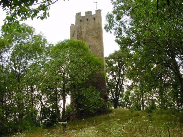
Tautenburg Castle Ruin is the ruin of a spur castle located about eleven kilometers northeast of Jena, in the middle of the Tautenburg Forest, on a small mountain spur around which the eponymous municipality of Tautenburg has formed a U-shape.
It is often assumed that the complex was built around the middle of the 12th century as the castle of an imperial ministerialis family. This is based almost exclusively on a connection, asserted already at the end of the 19th century, with a place called Tutenberc in the tradition of Arnold of Quedlinburg, which played a role in the history of the Vögte of Weida. While this cannot be completely ruled out, it seems unlikely. However, given the general castle development in the region, it is quite possible that a castle was founded here in the middle or second half of the 12th century. This was a time when a large number of castles in the middle Saale valley were newly built or rebuilt, for example, the upper Lobdeburg (before 1166), Camburg Castle (from approx. 1133), and Gleisberg Castle (Kunitzburg). Archaeological finds and findings that could provide information about the age of the complex are not yet available or have not been presented, so a decision must remain open for now.
The castle is first mentioned in a document in 1223. In the confirmation deed of a foundation, the nobles Tuto of Tautenburg (Tutenberc) and his son of the same name, as well as his cousins (consobrini eius), including another Tuto of Kohren, are mentioned. The foundation is made for the salvation of their deceased nephews Tuto and Friedrich. Tuto is obviously the leading name of the older family and probably also gave the castle its name. However, it remains unclear in which generation the name already appears here. The Tuto first mentioned in 1223 does not necessarily have to be the first of the family; theoretically, a Tuto one, two, or even several generations older could have been the founder. For example, a Tuto possibly appears already in the confirmation deed of Bishop Udo of Naumburg, but other readings such as Udo also exist here.
In 1227, the knight Tuto of Tautenburg is mentioned again in connection with a donation. Tautenburg was at this time in the hands of the Lords of Lobdeburg-Saalburg. Shortly thereafter, even before 1232, it initially passed as a Lobdeburg sub-fief to the Schenken of Vargula. After the death of Hartmann of Lobdeburg-Saalburg, they were enfeoffed with Tautenburg by Emperor Frederick II in 1243, and a collateral line named itself after Tautenburg (first documented in 1244).
In 1343, the Tautenburger had to take their castle as a fief from the Counts of Schwarzburg, and in 1345 from the Wettins. The younger line of the Schenken residing here died out in 1640. The Albertine Wettins seized the lordship as an escheated fief and used the castle as an electoral administrative seat until 1776. In 1780/81, the building fabric was demolished, except for some remnants, and the stones were used for the construction of the castle and the judicial and rent office in Frauenprießnitz.
Preserved Building Stock and Dating+
The complex is divided into two parts, of which some ditches and terracing are still visible. In the southeast corner of the western, older part, a pentagonal gate tower with a battlement and gate passage is preserved, often mistakenly referred to as a keep. Its chronological classification is unclear; it is mostly dated to the first half of the 13th century, which, however, is obviously based on the first mention. A piece of wall with opus spicatum and without lime mortar could suggest an earlier origin, but such a wall technique is also possible after 1200 and up to the middle of the 13th century. Another dating aid is a small quatrefoil window, also dated approximately to the second third of the 13th century. The gate tower could therefore also be related to new constructions, alterations, or extensions by Schenk Rudolf II of Vargula after the acquisition of the castle in the 1230s and 40s. This also applies to strong wall remnants of a northeast wing, which allegedly housed the chapel mentioned in a building inscription for the year 1232. To the west, a three-story residential building adjoined the tower, which is said to have had oriel turrets on the north side.
Take Mobile History with you
You are reading this text for free. Premium adds what matters on the road: descriptions read aloud, sites found through your camera, whole regions taken offline.
- Every description, including the ~17,700 Premium sites
- Audio guide: have descriptions read to you on location
- AR finder: see sites through your camera, with distance and bearing
- Unlimited saved sites
14 days free, then from €2.99 a month. Cancel anytime.
Source: Wikipedia · Licence: CC BY-SA 4.0 · Image: Roland Neubert, Halle (Saale)
This description draws on the facts documented in the linked Wikipedia article; Wikipedia content is licensed under CC BY-SA 4.0. Wording and editing: Mobile History.
Location: 50.9906, 11.7156