The remains of the Castle can be visited
CastleBaiersbronn-Obertal
Tannenfels Castle
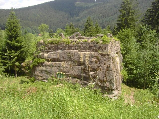
Tannenfels Castle is the ruin of a tower castle. It is located on a 645 m above sea level Bunter sandstone rock on the right side of the Murg Valley between Rechtmurg and Ilgenbach near the Obertal district of the municipality of Baiersbronn in the Freudenstadt district in Baden-Württemberg.
The visible remains of the tower castle today were built in the first half of the 13th century. However, ceramic finds and an older moat suggest that the castle rock was already occupied by a castle in the 11th or early 12th century, which was completely cleared during the later new construction. However, the castle was not inhabited for very long. Already in the first half of the 14th century, it fell victim to a fire, possibly in the course of a warlike conflict. Three arrowheads from a burnt layer could be attributed to this.
An associated nobility is not known. A noble family of Tannenfels, which was associated with the ruin, is, however, to be located in the Allgäu and therefore has nothing to do with the castle in the Murg Valley. They owned property in Aigeltshofen and Rohrdorf (Isny), among other places, and their namesake Tannenfels Castle also stood in the Allgäu opposite Eglofs Castle.
According to an 18th-century note, the castle is said to have been destroyed in the years 1371-1373 during a feud undertaken by Count Eberhard the Greiner together with the Diocese and City of Strasbourg. However, the archaeological and architectural-historical findings contradict this, as the castle was already destroyed before then.
Legends+
An underground passage is said to have once led to the castle, the opening of which was formerly visible in the tower but is now said to be buried. In Johannes Öttinger's Württemberg land register of 1624, due to its location in impassable wilderness, it is suspected that the castle was a robber's castle. Both are typical legendary topoi that are told about many castles.
Archaeological Excavations+
Due to increasing decay, archaeological excavations were carried out on the castle for a total of eleven weeks in 1977/78 by the Karlsruhe branch of the State Monuments Office. The aim was to record the existing structure, clarify the building history and settlement history of the castle rock, and prepare for restoration. The results were published in the publication series of Medieval Archaeology in Baden-Württemberg.
Description of the Castle+
The castle consisted of a tower with an irregular floor plan. Since its location on a large rock, which dropped ten to twelve meters vertically on all sides, offered natural protection, a surrounding wall could be dispensed with. The castle grounds were secured by moats and a natural small valley. The small rock in front was probably not built upon. The entrance could have led over it via wooden stairs. The tower was a total of three to four stories high, with the uppermost floor possibly being of timber construction. The ashlar masonry stones had an indentation on both sides. From this, it can be concluded that they were hoisted up with a crane-like lifting device. They were connected to each other with lime mortar. There are no indications about the internal layout. A hip roof or a lean-to roof is the most likely roofing option.
Take Mobile History with you
You are reading this text for free. Premium adds what matters on the road: descriptions read aloud, sites found through your camera, whole regions taken offline.
- Every description, including the ~17,700 Premium sites
- Audio guide: have descriptions read to you on location
- AR finder: see sites through your camera, with distance and bearing
- Unlimited saved sites
14 days free, then from €2.99 a month. Cancel anytime.
Source: Wikipedia · Licence: CC BY-SA 4.0 · Image: https://commons.wikimedia.org/wiki/File:Burg_Tannenfels_Obertal.jpg
This description draws on the facts documented in the linked Wikipedia article; Wikipedia content is licensed under CC BY-SA 4.0. Wording and editing: Mobile History.
Location: 48.5275, 8.3004