The remains of the castle can be visited
CastleSulzburg
Sulzburg Castle
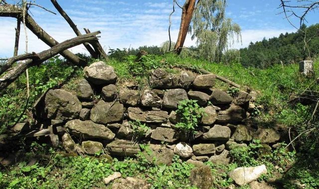
Sulzburg Castle is a vanished hilltop castle on a 380 m above sea level high hill (also called Schlössleberg) near the Klosterwald above the town of Sulzburg in the Breisgau-Hochschwarzwald district in Baden-Württemberg.
The castle was presumably built by the Lords of Uesenberg in the second half of the 12th century. In 1157, the Lords of Uesenberg are mentioned as protectors of Sulzburg Monastery. Under their rule, the town was fortified with walls and towers and achieved town rights around 1280. The Uesenbergers (until 1331) presumably received mining rights from the Diocese of Basel, which Emperor Konrad II had granted to the Basel Diocese around 1028, as well as the silver mines in Sulzburg. In this context, the construction of the castle complex on the Schlössleberg should be seen – it served to protect and control the significant mining in the Sulzburg Valley. There is no information about its demise.
Layout+
The castle complex rises on an elongated rock spur of gneiss rock, which may have been artificially piled up into a hill about the height of a house. The flattened, leveled summit forms an approximately rectangular area almost 50 m long and about 20 m wide. A few shallow depressions in the northern part indicate the location of structures or foundation remains in the ground.
At the narrowest points, ditches delimit the castle site – on the mountain side (northeast side), with the spreading Klosterwald there, a neck ditch; on the valley side (southwest side), a shallower, pre-positioned ditch. At the southern corner, a 7 m wide and on its east side 5.5 m deep wall projection forms, resembling a right-angled terrace, from which up to 2.5 m high wall foundations have been preserved. Adjoining this, individual, still recognizable wall remains are visible along the entire length of the southeastern slope edge; at the edge of the eastern corner, a large wall section about 7 m long and 4 m high. On the northwestern hillside, only minimal traces of former masonry can be found.
Take Mobile History with you
You are reading this text for free. Premium adds what matters on the road: descriptions read aloud, sites found through your camera, whole regions taken offline.
- Every description, including the ~17,700 Premium sites
- Audio guide: have descriptions read to you on location
- AR finder: see sites through your camera, with distance and bearing
- Unlimited saved sites
14 days free, then from €2.99 a month. Cancel anytime.
Source: Wikipedia · Licence: CC BY-SA 4.0 · Image: http://commons.wikimedia.org/wiki/File:Sulzburg_18b.JPG
This description draws on the facts documented in the linked Wikipedia article; Wikipedia content is licensed under CC BY-SA 4.0. Wording and editing: Mobile History.
Location: 47.8435, 7.7095