The remains of the Castle can be visited
CastleEberbach - Rockenau
Stolzeneck Castle
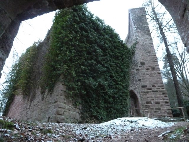
Stolzeneck Castle is the ruin of a hilltop castle above the Neckar near Eberbach in Baden-Württemberg. Built around 1200, the castle was granted as a Palatinate fief to servants of the Counts Palatine from 1284. After 1610, the castle and the associated castle hamlet of Krösselbach were abandoned.
The ruin of Stolzeneck is located about 2 km south of the Eberbach district of Rockenau, just within the municipal area of the neighboring community of Neunkirchen, on a 215 m above sea level rock spur at the sharp confluence angle of a small hillside stream gorge, which rises about 80 meters to the left above the Neckar, which flows northwards here. The small spur plateau is now forested.
The castle was probably built around 1200 as an imperial castle. The name was first mentioned in 1268 with a widow of Stoltzinecke. In 1284, Count Palatine Ludwig II acquired the castle. King Albrecht I promised Ludwig in 1291, in the event of his re-election, recognition of his rights to Stolzeneck and Reichenstein, as well as the enfeoffment with Kammerstein Castle and Dilsberg.
Over time, various noble families were enfeoffed with the castle, which included only minor appurtenances (the castle hamlet of Krösselbach, minor possessions in Rockenau, smaller lands and fishing rights). From 1418 to 1458, it was again in the possession of the Electoral Palatinate and thereafter granted to various feudal lords. The castle was probably damaged in 1504 during the Palatinate-Bavarian War of Succession, as Count Palatine Ludwig V concluded an agreement with Philipp von Seldeneck in 1509 regarding the timber felling necessary for the reconstruction of the castle. After the extinction of the Barons of Frauenberg in 1610, the castle reverted to the Electoral Palatinate and was not re-granted. A report from 1611 described the entire complex as dilapidated, whereupon the Electoral Palatinate Court Chamber decided to abandon the fief. The castle was released for demolition, and the associated lands, fishing rights, etc., were sold in 1612. The proceeds from the sales particularly benefited the last inhabitants of the castle hamlet of Krösselbach, which was also abandoned, which is why a financial basis was needed for the resettlement of the inhabitants to Zwingenberg.
The Electoral Palatinate Court Chamber had originally ordered the quarry stones of the castle to be broken out and transported by barges on the Neckar to Mannheim, where they were to serve as building material. However, since about 1000 barge trips would have been necessary, the project was not realized. The castle ruin rather fell into oblivion and was only uncovered again in the 1960s.
Layout+
Stolzeneck Castle consists of a core castle as well as an outer bailey and a zwinger. The terrain of the complex slopes down to the northeast towards the Neckar. The core castle is located in the southwest and is protected to the west by a shield wall and a neck ditch against the rising terrain and surrounded by a zwinger. The outer bailey extends to the northeast, following the sloping terrain. Access to the complex was originally at the eastern connection of the outer bailey and the zwinger; today, the main access is through an opening artificially created in the west.
The core castle consists of the shield wall with a battlement and the palas located to the northeast of it. During excavations in 1964, foundations were found that run diagonally to the walls of the four-story palas and the enclosure, so that the palas preserved today was probably built only after 1350, possibly only during the 16th-century alterations, abandoning the previous palas and accompanied by the enlargement of the inner courtyard of the core castle, and was subsequently rebuilt several times. The palas shows architectural attributes of various epochs. Of the 21-meter-high and 2.85-meter-thick shield wall, only the plinth area with bossed ashlar seems to date from the 13th century, as the dimensions of the wall correspond more to the defensive requirements of later centuries. The shield wall can be climbed. The battlement offered a good view over the Neckar valley from the once unwooded mountain spur.
The zwinger and outer bailey with cistern were built in the 15th or 16th century. Some foundation remains in the outer bailey bear witness to former farm buildings located there.
Take Mobile History with you
You are reading this text for free. Premium adds what matters on the road: descriptions read aloud, sites found through your camera, whole regions taken offline.
- Every description, including the ~17,700 Premium sites
- Audio guide: have descriptions read to you on location
- AR finder: see sites through your camera, with distance and bearing
- Unlimited saved sites
14 days free, then from €2.99 a month. Cancel anytime.
Source: Wikipedia · Licence: CC BY-SA 4.0 · Image: Bernd Walter
This description draws on the facts documented in the linked Wikipedia article; Wikipedia content is licensed under CC BY-SA 4.0. Wording and editing: Mobile History.
Location: 49.4254, 8.9991