To be privately owned
CastleLohmar
Schönrath Castle
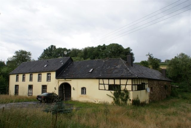
Schönrath Castle is a lowland castle in North Rhine-Westphalia, partially preserved only as a ruin. It belongs to the city of Lohmar and is located in the Rhein-Sieg district.
The small lowland castle is situated in the gently sloping spring hollow of a small stream that flows into the Gammersbach, at an altitude of 140 meters above sea level, between the districts of Lohmar-Wickuhl and Rösrath-Rambrücken, near the hamlet of Georgshof/Oberschönrath.
The former knight's seat is first mentioned in documents in the 13th century, at which time it belonged to the Lords of Schönrode. In the following centuries, the castle changed hands several times. It passed to various noble families of Landsberg, Nesselrode, and Quadt, until it came into the possession of the Plettenberg family in the 15th century. After the death of Wilhelm von Plettenberg, the castle and its lands were divided among the inheriting daughters. In 1563, Diederich von Heyden, son of Elisabeth von Plettenberg, was able to buy out his brothers-in-law and brought the castle into the family possession of the von Heyden for a good 100 years.
When, towards the end of the 17th century, the descendants of the von Heyden family gave up their possessions in the Bergisches Land and turned to Brandenburg, Schönrad Castle, together with its appurtenances (accessories, i.e., the associated estates), was sold for 30,000 Reichstalers to Baron Ernst von Erlenkamp on October 4, 1695. In connection with this sale, the amount of the former yields of the nine farms and two watermills belonging to the castle is recorded: 119 Malter of rye, 80 Malter of oats, 2 Malter of barley, 6 calves, 32 1/2 pigs, 1 wether, 7 cattle to be fattened, 8 sacks of coal, 32 pounds of flax, 100 eggs, 150 chickens, 4 pounds of pepper, 4 pounds of ginger, 6 pounds of sugar, 4 measures of butter, in addition to team services and cash amounting to 82 Reichstalers and 256 Stüber.
During the following two centuries, the value of the free noble estate significantly decreased as the associated farms were gradually sold to commoners. The population figures for the Schönrath estate are known from the 19th century: 1829 17 people at two hearths, 1843 15 inhabitants, 1851 10 inhabitants, 1872 12 people in two residential houses and two households. The castle itself also changed hands several times during this period until it belonged to the Scharrenbroich family from 1855 to 1925. The main castle, which was no longer inhabited in the 19th century – although the castle chapel is said to have been used until about 1835 – was gradually dismantled until the 1920s and blown up in January 1928, with the material used for road construction. The outer bailey was continuously used as an agricultural enterprise.
The buildings are now in private ownership.
Layout+
The main castle was built on medieval foundations in the 15th to 16th centuries. In the 18th century, the outer bailey was renovated, while the three-story main complex was significantly altered in essential parts. This, in the form of an angular castle, is accessible from the west via a brick bridge. The complex also features an octagonal castle chapel and is surrounded by a moat.
Today, the outer bailey, which consists of a two-story residential building, stables, and outbuildings, is inhabited by the owners.
Only minor, heavily overgrown wall remnants of the main castle exist. The former moat has almost completely silted up, except for a pond. Next to the access road to the outer bailey stands a approximately 300-year-old yew tree with an unusually multi-stemmed crown.
The castle complex cannot be visited, but only viewed from the nearby road.
Take Mobile History with you
You are reading this text for free. Premium adds what matters on the road: descriptions read aloud, sites found through your camera, whole regions taken offline.
- Every description, including the ~17,700 Premium sites
- Audio guide: have descriptions read to you on location
- AR finder: see sites through your camera, with distance and bearing
- Unlimited saved sites
14 days free, then from €2.99 a month. Cancel anytime.
Source: Wikipedia · Licence: CC BY-SA 4.0 · Image: Roland Neubert, Halle (Saale)
This description draws on the facts documented in the linked Wikipedia article; Wikipedia content is licensed under CC BY-SA 4.0. Wording and editing: Mobile History.
Location: 50.8898, 7.2151