The remains of the castle can be visited
CastleObermünstertal
Scharfenstein Castle
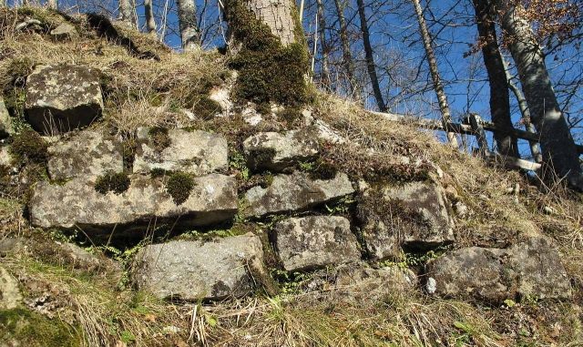
Scharfenstein Castle is the ruin of a hilltop castle at 922 m above sea level on an imposing rock formation in the rear Münstertal valley near the district of Obermünstertal in the municipality of Münstertal in the Breisgau-Hochschwarzwald district in Baden-Württemberg.
The castle was built in the 12th century by the Lords of Staufen. Archaeological finds at the castle site suggest this early beginning of the complex. Since 1211, the Lords of Staufen have been documented in writing as bailiffs and lords of the court of St. Trudpert Monastery in Münstertal. To consolidate their rule, in the course of the development of the town of Staufen and the mining town of Münster, the two castles of Scharfenstein and Staufen were built at the entrances to the eastern and western Münstertal. In 1267, the castle was first mentioned as "castrum Scharphenstein" in the possession of the Lordship of Staufen. Strategically located on the mule track to the Wiesental, it served to protect the surrounding silver ore mines. Presumably, financial difficulties forced the Lords of Staufen to sell a quarter of the bailiwick rights and Scharfenstein Castle to St. Trudpert Monastery in 1325. In 1330, further partial rights were sold to the House of Habsburg and the city of Freiburg. In the dispute between these forces, especially between the monastic rule of St. Trudpert and the citizenry of Freiburg, over unredeemed pledge sums and property rights, particularly over the exercise of mining sovereignty and the associated tangible financial interests in the rich silver ore deposits in the Münstertal, but also because of advantages gained through the falsification of documents and ransom demands for kidnapped merchants, a warlike conflict broke out in 1346. Advancing over the Schauinsland, Freiburg armed forces destroyed Scharfenstein Castle and devastated the mining town of Münster, which was fortified with walls and towers. The castle complex was not rebuilt thereafter. In 1480, it was mentioned as a castle site in the possession of St. Trudpert Monastery.
Layout+
The former castle complex extended over three rocks with a main castle on the rock plateau in the east. Its access is likely identical to today's ascent path. It runs, fortified by remnants of retaining walls, in a long serpentine loop along the northern flank to the castle site. Below the main plateau, the footpath reaches an elongated rock terrace, which extends to the northeast side of the castle rock and was probably laid out as an outwork or lower castle with a castle courtyard. From it, a wall remnant about 7.5 m long and up to 1.2 m high, made of irregular small ashlar stones, remained on the north side. At its southeastern end, stone steps lead to the large rock plateau of the upper castle. The outer outline of this core castle forms an approximately right-angled trapezoid with side lengths between 35 m in the north and 38 m on the south side, where the settlement area was enlarged by a rectilinear overbuilding of a funnel-shaped rock slide. With 13.5 m on the east side, the complex reaches its greatest width, which remains roughly constant over a length of about 20 m, but then significantly narrows to 8.5 m on the west side. Here, as on the southern edge, there are still small wall remnants of regular small ashlar stones.
Striking is a fragmentarily preserved section of wall made of relatively regularly hewn and laid porphyry ashlar stones on the northern edge of the core castle. To the west, a deep, neck-ditch-like crevice breaks through the main rock and isolates its significantly smaller rock end, which forms the central castle rock. No visible traces of settlement can be seen on it. Separated by a ditch-like depression, the third, western castle rock follows. Here, remnants of a square tower, with a clear width of about 2.70 m and approximately 1.70 m thick masonry, have been preserved. A few meters below, towards the southern valley side, two corner-pillar-like rock workings catch the eye, between which an formerly 8.5 m wide retaining wall ran, of which only small remnants remain. Further in the southwest direction, the rocky terrain slopes gently towards the ridge of Scharfenstein. A niche-like rock recess, which breaks through the ridge approximately halfway along its length, as well as a flattened plateau-like elevation in front of the spur end, possibly served as an advanced lookout. Wooden superstructures would be conceivable here, but are not proven.
Take Mobile History with you
You are reading this text for free. Premium adds what matters on the road: descriptions read aloud, sites found through your camera, whole regions taken offline.
- Every description, including the ~17,700 Premium sites
- Audio guide: have descriptions read to you on location
- AR finder: see sites through your camera, with distance and bearing
- Unlimited saved sites
14 days free, then from €2.99 a month. Cancel anytime.
Source: Wikipedia · Licence: CC BY-SA 4.0 · Image: http://commons.wikimedia.org/wiki/File:Burg_Scharfenstein,_M%C3%BCnstertal_24.JPG
This description draws on the facts documented in the linked Wikipedia article; Wikipedia content is licensed under CC BY-SA 4.0. Wording and editing: Mobile History.
Location: 47.8668, 7.8543