The remains of the castle can be visited
RuinOberscheinfeld
Scharfeneck Castle
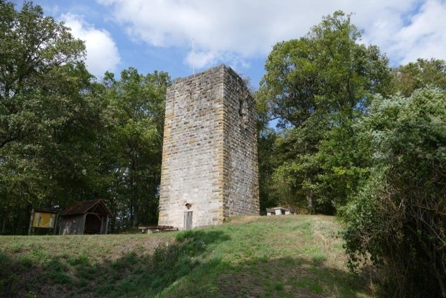
The Scharfeneck ruin is the ruin of a spur castle northeast of the market town of Oberscheinfeld on the Schlossberg, a 425-meter-high mountain spur of the Steigerwald. Of the original Scharfeneck Castle, only the 16-meter-high keep remains today, which is maintained as an observation tower by the Steigerwaldclub.
Scharfeneck Castle, known as "Veste Scheinfeld" until the 16th century, was probably founded as early as the 6th century during the Frankish landnahme by a Frankish nobleman named Scego or Skago. The predecessor castle, of which no remains have survived, was demonstrably the seat of the noble free Frankish family of Scheinfeld (Sgegevelet 1114, Segevelt 1151, Sheigenvelt 1186) in the High Middle Ages, to which, among others, the Bishop of Worms Leopold II von Schönfeld (Scheinfeld) belonged. Around the year 1202, the Scharfeneck knight Friedrich de Scevelt pledged his property to Bishop Thiemo of Bamberg to prepare for the 4th Crusade (1202 - 1204). After his death, the castle fell to the Diocese of Bamberg. In 1339, the castle appears in the Bamberg castle guard register, when Johann von Dachsbach, bailiff and knight of Scheinfeld, was granted a hearth "behind the tower" including grapevines. After 1366, the castle repeatedly changed owners, including the Bamberg canon Count Albrecht von Wertheim and the Knights of Kappel. After the castle was already described as dilapidated ("ein öd schlos trob") in 1504, the Bamberg officials proceeded to demolish it around 1545 to build a new, more comfortable castle with the stones in the center of Oberscheinfeld. Only the keep remained as a lookout on the Schlossberg.
Today, the keep is accessible on Sundays and public holidays during the summer half-year.
On the Schlossberg, there is no concrete evidence of a castle complex before the 13th century. There is also no trace of the St. Catherine's Chapel on the Schlossberg, mentioned in 1504. On the mountain spur, separated by two neck ditches, the keep is the only remaining upstanding castle remnant, lacking only a few meters of its original height of about 20 meters today. The massive keep made of bossed ashlar dates from between 1220 and 1235, as indicated by the shape of the bossed ashlar and the design of the tower. With a side length of 7.2 meters and a wall thickness of 2.8 meters, the tower probably served as a symbol of power, a lookout, and a secure storage place. It rises over a square floor plan and concludes with an observation platform. The outer walls consist of carefully hewn reed sandstones, which are particularly bossed at the corners. The ornamental arrangement of the differently colored sandstone ashlar is striking: while the basic structure of the tower consists of gray sandstone, the corner ashlar shows beige-yellowish stones. The west wall still contains the original high entrance at a height of 10 meters, which led into a small room with a Romanesque vaulted window chamber. However, a chimney planned here was obviously not implemented. At the end of the 19th century, the tower was opened for tourism by breaking a ground-level passage into the masonry and installing a 77-step wooden staircase. In 1972/73, this staircase was renewed and reduced to 74 steps. The most recent renovation of the tower was carried out by the Steigerwaldklub, Oberscheinfeld branch, between 1999 and 2001, with careful stone additions and repairs to the observation platform (442.6 m above sea level).
Take Mobile History with you
You are reading this text for free. Premium adds what matters on the road: descriptions read aloud, sites found through your camera, whole regions taken offline.
- Every description, including the ~17,700 Premium sites
- Audio guide: have descriptions read to you on location
- AR finder: see sites through your camera, with distance and bearing
- Unlimited saved sites
14 days free, then from €2.99 a month. Cancel anytime.
Source: Wikipedia · Licence: CC BY-SA 4.0 · Image: Mobile Geschichte
This description draws on the facts documented in the linked Wikipedia article; Wikipedia content is licensed under CC BY-SA 4.0. Wording and editing: Mobile History.
Location: 49.7138, 10.4446