The remains of the Castle can be visited
CastleNaumburg-Saaleck
Saaleck Castle
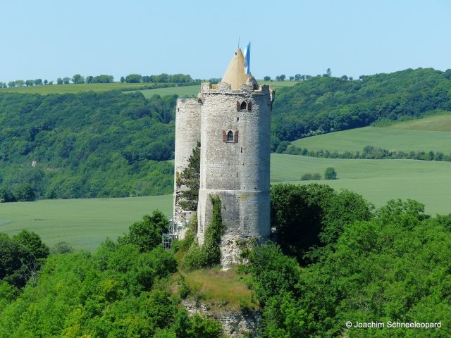
Saaleck Castle is located only a few hundred meters from Rudelsburg Castle, upstream of the Saale river above Bad Kösen in the village of Saaleck in the Burgenlandkreis district of Saxony-Anhalt. The hilltop castle borders this village, which is its namesake, to the south. The castle is only preserved as a ruin and is a popular excursion destination. It is located on the Romanesque Road.
The castle is situated on a roof-shaped, westward-projecting Muschelkalk ridge immediately south of the village of Saaleck, approximately 172 meters above sea level and is almost 23 meters high. The characteristic image of the castle is formed by the two widely visible round keeps, whose wall thickness is about two meters. In the masonry of the west tower, there is a medieval latrine system and a fireplace, which indicate the habitable floor. The core castle was once enclosed by an inner and outer defensive wall. Remains of several residential buildings are preserved on the inner wall. A ditch with an outer rampart was laid out on each of the two narrow sides of the surrounding terrace. Further neck ditches with ramparts are located on the east side of the spur facing Rudelsburg Castle.
Comparable castle complexes with two round keeps include Münzenberg, Hohandlau, Botenlaube, and Thurant.
The Castle in the Middle Ages and Early Modern Period
In 1140, the noble free lords of Saaleck, with Hermannus advocatus de Salek, are first mentioned in documents. They subsequently appeared in the retinue of the Bishop of Naumburg as well as the Landgrave of Thuringia and the Margrave of Meissen. The builders of the castle were probably the Thuringian Landgraves. Around 1220, the castle came into the possession of the Schenken von Vargula. Rudolf II, Landgrave's cupbearer and Lord of Saaleck, is particularly well-known in posterity because he served at the court of Hermann I and followed Ludwig IV as a crusader to Otranto.
The towers and parts of the outer enceinte wall likely date from the late 12th century. This is particularly evident in the west tower, which can be dated to this period due to its careful stone masonry and equipment with a fireplace and latrine. The east tower is also Romanesque in its core, but was rebuilt from about the upper edge of the former curtain walls in the Gothic period, or at least its outer skin was renewed. The extensive outer facilities, of which only minor traces of walls are still visible, have so far been little researched. Allegedly, they are said to have encompassed the village of Saaleck.
Castle Romanticism of the 19th Century
Since the mid-19th century, the student song "Dort Saaleck, hier die Rudelsburg," penned by Hermann Allmers, has celebrated the romantic landscape of the Saale valley with its two neighboring castles.
During archaeological excavations in 1930, the castle's well was discovered, but a clarification of the medieval building contexts could not be achieved.
The Castle during the Weimar Republic and National Socialism
In 1922, a castle tower was the last hiding place of Walther Rathenau's assassins, Erwin Kern and Hermann Fischer, who were discovered there on July 17, 1922. During the arrest, one of the assassins was shot, the other committed suicide. The then tenant, Hans-Wilhelm Stein, who had provided shelter to the assassins, was convicted for it.
On July 17, 1933, the militaristic associations Stahlhelm, Bund der Frontsoldaten, and leaders of the Ehrhardt Brigade, in alliance with the SS and SA, dedicated a memorial plaque for those they revered as "heroes" on the castle's keep. In October of the same year, a memorial stone was erected for them in the cemetery of Saaleck village after a "solemn church service" by relatives and Nazi dignitaries. Due to increasing pilgrimages by right-wing groups, this stone was removed and destroyed in 2000 by the local pastor with the help of the Bundeswehr.
Take Mobile History with you
You are reading this text for free. Premium adds what matters on the road: descriptions read aloud, sites found through your camera, whole regions taken offline.
- Every description, including the ~17,700 Premium sites
- Audio guide: have descriptions read to you on location
- AR finder: see sites through your camera, with distance and bearing
- Unlimited saved sites
14 days free, then from €2.99 a month. Cancel anytime.
Source: Wikipedia · Licence: CC BY-SA 4.0 · Image: Joachim Schneeleopard
This description draws on the facts documented in the linked Wikipedia article; Wikipedia content is licensed under CC BY-SA 4.0. Wording and editing: Mobile History.
Location: 51.1097, 11.7010