The remains of the Castle can be visited
CastlePierbach
Ruttenstein Castle
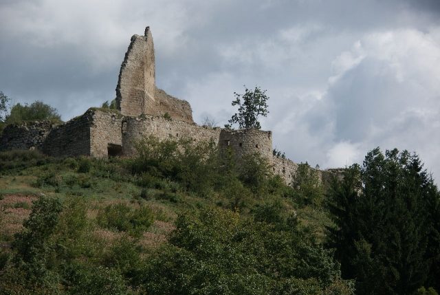
Ruttenstein Castle Ruin is located approximately 3.5 km northeast of Pierbach in the Freistadt district in the Mühlviertel region of Upper Austria. The extensive complex of the former hilltop castle is situated on a wooded conical hill at an elevation of 758 m above sea level, overlooking the valley of the Große Naarn in the village of Niederhofstetten, which belongs to the municipality of Pierbach.
Name+
The name (documented as: Rotenstein) presumably derives from a slight reddish coloration of the local granite rock. The dative use of place names common in the Middle Ages led to the current contracted place name: (to the) red stone – Rotenstein – Ruttenstein.
A legendary interpretation suggests that the castle name is derived from the bony fish species burbot (Rutte): During a siege, the castle garrison is said to have feigned having sufficient provisions by throwing burbot, which were kept in a pond, over the wall (see below: Weblink). However, due to the fact that the castle was historically called Rotenstein, this interpretation must be considered demonstrably historically incorrect.
Description+
The walls of the formerly massive pentagonal keep are only preserved in remnants and, tapering to a point and visible from afar, tower over the complex. The former residential wing in the west is preserved on three sides. An observation platform has been erected above them, freely accessible via wooden stairs. Clearly recognizable, but also only preserved in remnants, is the early Gothic castle chapel located near the stone staircase to the residential building. The actual main castle was protected to the north, south, and east by a mighty curtain wall, parts of which are still preserved today, from which seven wall towers projected. The total built-up area is 4,800m2, and that of the main castle is 1,600m2.
As early as February 14, 1160, a Castrum Rotenstein is mentioned. The complex is first documented (as Rotensteine) on January 31, 1209, in a document issued by Duke Leopold VI to Baumgartenberg Abbey. On May 2, 1281, King Rudolf of Habsburg pledged Ruttenstein, among other properties, to Ulrich II von Kapellen. After the extinction of the noble family of Kapeller, the castle was granted in 1418 as a fief to Reinprecht II von Walsee, captain of the Enns, who was married to Anna, the daughter of the last Kapeller. In 1483, the Liechtensteins came into possession of Ruttenstein as a pledge, followed by the Meggauer family from 1556. Leonhard Helfried von Meggau was also the owner of the Greinburg lordship since 1621. In 1615, Ruttenstein was purchased by the Meggauer family and became their private property until the lordship passed to the Dietrichsteiner family through inheritance in the 17th century. In 1811, the lordship complex was initially sold to the army supplier Michael Fink from Hainburg, whose estates, including Ruttenstein, passed to the Dukes of Saxe-Coburg and Gotha in 1823. The complex remains in the possession of their descendants to this day.
As early as 1551, the castle was dilapidated; by 1585, the entire roof was already missing, and in the engraving by Georg Matthäus Vischer from around 1674 (see above), Ruttenstein was already a ruin.
Current Use+
The Ruttenstein Preservation Society, based in Pierbach, is responsible for the maintenance of the current ruin. For a few years now, a restaurant has been located about a 10-minute walk from the complex, from where guided tours are offered during the summer months. The ruin can be reached from Pierbach via hiking trail No. 95, and from Mönchdorf via hiking trail No. 13. In 2010, the wooded area south below the ruin was cleared. Since then, the complex, as in the time of its use in the Middle Ages, is once again visible from afar.
Take Mobile History with you
You are reading this text for free. Premium adds what matters on the road: descriptions read aloud, sites found through your camera, whole regions taken offline.
- Every description, including the ~17,700 Premium sites
- Audio guide: have descriptions read to you on location
- AR finder: see sites through your camera, with distance and bearing
- Unlimited saved sites
14 days free, then from €2.99 a month. Cancel anytime.
Source: Wikipedia · Licence: CC BY-SA 4.0 · Image: http://commons.wikimedia.org/wiki/File:Ruttenstein_02.JPG
This description draws on the facts documented in the linked Wikipedia article; Wikipedia content is licensed under CC BY-SA 4.0. Wording and editing: Mobile History.
Location: 48.3783, 14.7711