The remains of the Castle can be visited
CastleHeubach
Rosenstein Castle
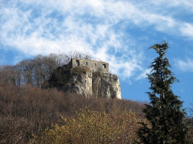
The Rosenstein castle ruin is the ruin of a hilltop castle located about 1500 meters east of the town of Heubach in the Ostalbkreis district in Baden-Württemberg.
The ruin is situated on a spur at about 686 meters above sea level on the Rosenstein above the western cliff. The exposed location on the edge of the Swabian Alb on a spur of the Alb escarpment has always had great strategic importance. The outer and main bailey are freely accessible. Below the complex lies the Kleine Scheuer cave.
In a document from Kaisheim Monastery from 1234, a "miles Hainricus de Hobach" is mentioned among other persons. Presumably, these local nobles from Heubach left the area in the mid-13th century to build a hilltop castle on the mountain spur above the town, which was a common trend at the time. In 1282/83, a "Hainricus de Rosenstein," who belonged to the same noble family, is mentioned for the first time in a donation document by Count Ludwig V of Oettingen. Thus, this document is the first written mention of the castle. The lords of the castle were demonstrably vassals of the Counts of Oettingen. In early sources, the castle is often mentioned in connection with the neighboring Lauterburg, first documented in 1128. In 1338, Albert Haugke, a member of the Hacken von Wöllstein – also vassals of the Oettingers – appeared in the retinue of the county as the owner of Rosenstein Castle. By 1360 at the latest, Rosenstein Castle and Heubach, which was designated as a town for the first time at this point, were pledged to Württemberg. After a defeat in 1360 before Schorndorf, Eberhard II of Württemberg had to cede this pledge to Emperor Charles IV. Heubach thus briefly gained the status of a free imperial city. In 1377, however, Lauterburg, Rosenstein Castle, and the cities of Aalen and Heubach were pledged back to Württemberg for 20,000 guilders. In 1413, the Lords of Wöllwarth were enfeoffed by Count Eberhard III with Heubach, Rosenstein, and some other places in the vicinity. In 1430, this feudal relationship was converted into a pledge agreement. In 1480, Count Eberhard the Younger sold Heubach and Rosenstein for 1800 fl. to the brothers Renwarth and Jörg V von Wöllwarth with the reservation of reacquisition. The heir Georg VII finally left the castle as his residence before 1524 and built a "noble house" in the town, the Heubach Castle, which still exists today. The castle subsequently fell into rapid disrepair, and the walls and remains of buildings served as a quarry for the inhabitants of Heubach. In the Gmünd hunting map of 1572, the castle is already depicted as a ruin. Only the west wall of the palas has survived to the present day.
At the beginning of the 19th century, against the backdrop of Romanticism, poets and linguists such as Ludwig Uhland and Gustav Schwab were drawn to Rosenstein, and landscape painters like August Seyffer made sketches of the ruin. With the construction of the Remsbahn in 1861, more and more excursionists came to Heubach, who also began to take an interest in Rosenstein. In the late 1880s, at the instigation of the Heubach pharmacist E. Plicksburg, the "Verschönerungsverein" (Beautification Association) was founded, which made it its task to make the landscape, caves, and ruin accessible and to maintain them. This Beautification Association later merged into the Swabian Alb Association. In 1887, the Royal Württemberg Forest Administration began to restore the endangered remains of the walls and cleared the interior of rubble. In 1892, the Swabian Alb Association built a cast-iron footbridge in place of the former drawbridge.
Today, the castle ruin is owned by the town of Heubach.
Description+
Outer Bailey
The former castle area begins 100 m west of the "Waldschenke" restaurant in gently sloping terrain with a 15 m wide and up to 4 m deep ditch cut into the rock, which isolates the spur from the plateau at a naturally advantageous point. Immediately behind the ditch, the terrain rises again and forms a hill with the Lärmfelsen, which clearly overlooks the foreland and the castle. According to an older report, a watchtower is said to have stood on the Lärmfelsen, which served to warn the castle inhabitants in time of danger. However, the foundations still visible at this point are the remains of a shelter built in the 19th century. In 1887, however, mortared wall remains were found at the western edge of the ditch, suggesting a former fortification. Since the foreland overlooks the main castle, it can be assumed that an outer bailey was built at this point, in which the stables, storage buildings, and accommodations necessary for economic supply were housed in a secure location.
Main Castle
The second, decisive obstacle to approach is the castle moat, on average 14 m deep and 15 m wide, which was laid out at the narrowest point. Today, a cast-iron footbridge leads over this moat to the main castle in place of the former drawbridge. The moat served the builders of the castle to obtain material for the castle walls. The relatively limited area of the main castle led to the fact that the construction and fortification of the main castle extended over several levels: At the top, the core complex with the palas and other buildings, whose size, location, and function are largely unknown. A lower-lying, also well-fortified area not only served to secure a cistern but also offered the possibility of constructing further buildings. A second access with a Zwinger (outer ward) was built close above the bottom of the moat, presumably for the castle's water supply.
Take Mobile History with you
You are reading this text for free. Premium adds what matters on the road: descriptions read aloud, sites found through your camera, whole regions taken offline.
- Every description, including the ~17,700 Premium sites
- Audio guide: have descriptions read to you on location
- AR finder: see sites through your camera, with distance and bearing
- Unlimited saved sites
14 days free, then from €2.99 a month. Cancel anytime.
Source: Wikipedia · Licence: CC BY-SA 4.0 · Image: Peter Schneider
This description draws on the facts documented in the linked Wikipedia article; Wikipedia content is licensed under CC BY-SA 4.0. Wording and editing: Mobile History.
Location: 48.7891, 9.9441