The remains of the Castle can be visited
CastleKobern-Gondorf
Niedernburg Castle
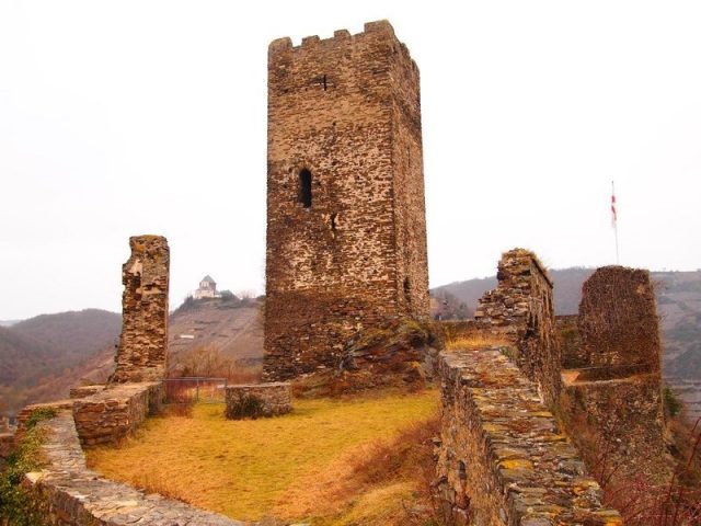
The Niederburg Kobern, also known as Niedernburg, Unterburg, or Neue Burg, is a hilltop castle above the municipality of Kobern-Gondorf in the district of Mayen-Koblenz in Rhineland-Palatinate.
The ruins of the Niederburg rise at an altitude of approximately 150 m on a mountain ridge projecting towards the Moselle, above the village of Kobern. On the same mountain ridge, about 50 m higher, lies the Oberburg Kobern with the Matthias Chapel.
Architectural Description+
The castle has an almond-shaped floor plan. In addition to the three-story, 20-meter-high keep with a high entrance at a height of 10 meters on a base area of 7.5 by 8 meters, remnants of a two-story late Gothic palas rise. A wall tower and a cistern are well preserved. Otherwise, mainly parts of the outer walls are found. The castle was protected to the west by a curtain wall with a Zwinger (outer bailey) system and to the north by a neck ditch. The upper third of the keep and the battlements were already reconstructed in the 19th century. The state castle administration reconstructed and supplemented the palas and the cistern located between the tower and the palas between 1976 and 1978.
The castle was built in the middle of the 12th century. It was first mentioned in 1195, when the then lord of the castle enfeoffed it to the Archbishop of Trier. The Lords of Isenburg-Kobern died out in the female line in the 13th century. Through the heiress Cecilia, the Kobern castles and the lordship passed to Frederick II of Neuerburg (a collateral line of the Counts of Vianden). In 1309, this line also died out in the male line. Afterwards, the castle and lordship were sold to the Archbishop of Trier. In 1688, the castle was destroyed.
Visiting+
The castle complex is accessible all year round and can be visited free of charge. The keep could be entered by carefully climbing through a narrow breach in the wall, but the interior does not justify the cumbersome climb.
The ascent to the castle is via a narrow footpath from the Mühlbach valley.
Take Mobile History with you
You are reading this text for free. Premium adds what matters on the road: descriptions read aloud, sites found through your camera, whole regions taken offline.
- Every description, including the ~17,700 Premium sites
- Audio guide: have descriptions read to you on location
- AR finder: see sites through your camera, with distance and bearing
- Unlimited saved sites
14 days free, then from €2.99 a month. Cancel anytime.
Source: Wikipedia · Licence: CC BY-SA 4.0 · Image: http://www.wehrbauten.de/thread.php?threadid=612
This description draws on the facts documented in the linked Wikipedia article; Wikipedia content is licensed under CC BY-SA 4.0. Wording and editing: Mobile History.
Location: 50.3106, 7.4557