The remains of the Castle can be visited
RuinEderheim - Hürnheim
Niederhaus Castle
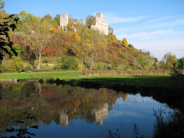
Niederhaus Castle is the ruin of a Staufer-era hilltop castle at 490 m above sea level, near Ederheim (Hürnheim district) in the Ries (Donau-Ries district) in Swabia. In the immediate vicinity of the ruin, the former farmstead – still in operation – has been preserved. Only about one kilometer away lies the large castle ruin Hochhaus on a ridge overlooking the Kartäusertal valley.
The castle was built in the 12th century as the ancestral seat of the noble free lords of Hürnheim. They had come here from the Worms and Speyer area. In the 10th century, they had still been settled with a farmstead in Hürnheim itself. The original name of the complex was Hürnheim Castle; later, to distinguish it from the nearby Hochhaus Castle, the fortress was called Niederhaus.
Whether there was an earlier defensive structure at the site of the present castle is purely speculative. In any case, the impressive double moats (see description) suggest such an early medieval castle complex. Only a few kilometers away, on the Weiherberg, lies a huge Hungarian defense castle (10th century) in the forest, so the Niederhaus castle site could well have served as a Hungarian refuge.
In 1379, troops of the Swabian League of Cities devastated the castle complex, which was subsequently quickly repaired. With Hans Johann, the Lords of Hürnheim died out in the male line in 1585; the daughter sold the castle in 1597 to the Counts of Oettingen-Oettingen for 38,000 guilders.
In 1633 (Thirty Years' War), a Swedish cavalry troop demanded provisions from the castle garrison, which was refused – due to the small number of riders and the imagined impregnability of Niederhaus. Allegedly, the castle warden's daughter even shot the Swedish captain. After the Swedes had called for reinforcements, they besieged the castle and entered the castle courtyard at night through a breach in the water tower.
The resulting destructions do not seem to have been so severe; the castle was in any case repaired again and sold to the Teutonic Order in 1709 for 53,000 guilders.
When the Teutonic Order was dissolved in 1805 during the secularization, the castle complex came into the possession of the newly founded Kingdom of Bavaria.
In the course of 19th-century ruin romanticism, the two neighboring castles, Hochhaus and Niederhaus, were deliberately allowed to fall into ruin. The picturesque Kartäusertal valley remains a popular local recreation and excursion area for the nearby cities of Nördlingen and Donauwörth.
On May 6, 2012, a Staufer stele was inaugurated in front of the castle in honor of Friedrich von Hürnheim, who was beheaded in Naples on October 29, 1268, together with the last Staufer king, Conradin. The keynote speech was given by the German ex-astronaut and physicist Ulf Merbold.
Description+
The castle ruin is impressively situated on the western end of a rocky ridge above the valley of the small Forellenbach stream. The complex is surrounded by a strikingly deep, double moat system. Such unusually deep moats usually indicate older, especially Hungarian-era predecessor castles or ramparts, but documentary or other evidence for this is lacking.
Of particular note is the former farmstead located northeast of the castle, which impressively documents the rarely preserved connection between a castle and its associated agricultural operation. The farm is still in operation today, while the castle has been uninhabited for centuries.
Between the farmstead and the present ruin, the outer bailey was formerly located; remains of a gate were found in 1978 near the current access to the castle area.
A modern bridge crosses the outer neck ditch, behind which rises the slender keep. With its base dimensions of approximately 6.5 x 6.5 meters and a current height of 23 meters (formerly approx. 30 meters, approx. 7 meters removed due to risk of collapse), the keep is one of the smaller examples of its type, with a wall thickness of approx. 1.70 meters on the ground floor. The original high entrance is on the south side; today, one can also enter the tower's interior on the ground floor. According to literature, the foundations are from the 12th century, but in its current form, it likely dates from the 13th century. Some ashlar blocks are incorporated into the ashlar masonry made of suevite stone.
The now three-story palas adjoins the keep directly; the former fourth story has only been preserved in remnants. The palas had base dimensions of 29 x 13.6 meters (all measurements according to Schmitt). Access to the palas was via a 3-story stair tower standing in the castle courtyard, which was located about 4 meters in front of the palas's west side, leading to the 3rd palas story via a drawbridge that could be extended from the palas to the stair tower. It was the only access to the palas building. The Kemenate (women's quarters) was also located on this 3rd floor of the palas. The upper floors show numerous – apparently later altered – window openings. The masonry largely dates from the 13th and 14th centuries and corresponds to that of the keep.
Past the palas, one reaches the castle courtyard; the inner gate has now disappeared. A memorial plaque for Friedrich von Hürnheim, inaugurated in 1868, is embedded in the curtain wall. He was beheaded in Naples in 1268 together with the young King Conradin of Hohenstaufen. His brother Hermann v. Hürnheim, who had also marched with the Staufer, returned safely to Hürnheim Castle in January 1269. The castle courtyard is enclosed by the remains of a small gatehouse, which formerly allowed access to the so-called "Hinteres Haus" (Rear House), whose ruins adjoin it. This "Hintere Haus" was the first castle "Hurnhain" = Hornwald, today Hürnheim, built as a fortified residential tower, on which the Hürnheimer is mentioned in a document in 1153. There is still a room plan of this residential tower at Harburg Castle in the archive of the Princes Oettingen-Wallerstein from the year 1619, where they renewed the dilapidated wooden interior walls. On the ground floor was the horse stable, on the first floor the lord's apartment with a small inner battlement in the east and half of the south area of the residential tower, from which one could access a small room, the kitchen, a large room, and the large chamber. On the 2nd floor were two equally sized chambers one behind the other for the servants.
Originally, the residential tower was accessible on the 1st floor with a ladder. Only at the beginning of the 13th century, when the castle was extended to the east, was the stair tower (Schnecken), which still exists in remnants today, added to the residential tower.
On the south side of the main castle is the eight-meter-high cistern tower, through which the Swedish conquerors are said to have entered the castle in 1634. It was originally about 10 meters higher, and water was drawn via the battlement.
The castle ruin, secured by the Kingdom of Bavaria in 1868 and 1901, and in 1985 and 2006, is freely accessible at all times. Comparisons with engravings and drawings from the mid-19th century (see Sponsel/Steger) show no major loss of substance during the last 150 years. However, the low tower of the inner gate is still documented here, which is completely missing in a view from 1861. At the beginning of the 19th century, larger parts of the outer curtain wall were still present.
Take Mobile History with you
You are reading this text for free. Premium adds what matters on the road: descriptions read aloud, sites found through your camera, whole regions taken offline.
- Every description, including the ~17,700 Premium sites
- Audio guide: have descriptions read to you on location
- AR finder: see sites through your camera, with distance and bearing
- Unlimited saved sites
14 days free, then from €2.99 a month. Cancel anytime.
Source: Wikipedia · Licence: CC BY-SA 4.0 · Image: Peter Schneider
This description draws on the facts documented in the linked Wikipedia article; Wikipedia content is licensed under CC BY-SA 4.0. Wording and editing: Mobile History.
Location: 48.7905, 10.4963