The remains of the Castle can be visited
CastleFlemlingen
Neuscharfeneck Castle
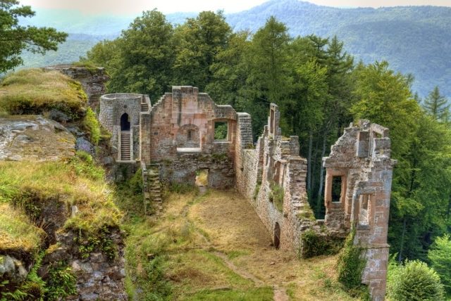
The castle of Neuscharfeneck is a ruin and a cultural monument above Ramberg and Dernbach on the territory of an exclave of Flemlingen in the district of Südliche Weinstraße in the west German state of Rhineland-Palatinate.
The ruins are situated in the eastern part of the Palatine Forest. They lie at an elevation of 500 metres on the western foothills of the Kalkofen Berg in the middle of a forest and are only accessible over forest tracks.
The first castle, dating to the 13th century, was considerably smaller than the present ruins. Of the Hochstaufen castle only a few remnants have survived.
The entire site measures ca. 150 × 60 metres. Its shield wall, built from ca. 1212 to 1232 and extended in the years 1470 and 1530, is the mightiest in the Palatinate, with a length of 58 metres and thickness of 12 metres. Within the shield wall there are relatively few usable passages, chambers and casemates. It therefore acted - apart from the hoarding (Plattform) that has not survived - primarily as passive protection for the castle behind it. The original entrance was over a drawbridge through the shield wall into the castle.
In the castle gardens, rare herbs such as White Henbane, Ingräu and Abbey Hysop were planted.
There is still a partially surviving gateway with a flanking tower. Four water basins, chiselled out of the rock in the 13th century, were used as cisterns, that were supplied with rainwater and, from the 16th century, with water from the Roßberg Spring, two kilometres away, over pipes made of clay or hollow tree trunks.
The 30 metre long upper castle (Oberburg) on the central rock was built from 1212 to 1232 as the first residential building but has unfortunately not survived, apart from its well and an inaccessible chamber and steps in the rock.
Take Mobile History with you
You are reading this text for free. Premium adds what matters on the road: descriptions read aloud, sites found through your camera, whole regions taken offline.
- Every description, including the ~17,700 Premium sites
- Audio guide: have descriptions read to you on location
- AR finder: see sites through your camera, with distance and bearing
- Unlimited saved sites
14 days free, then from €2.99 a month. Cancel anytime.
Source: Wikipedia · Licence: CC BY-SA 4.0 · Image: Dr. Gebhard Gaukler
This description draws on the facts documented in the linked Wikipedia article; Wikipedia content is licensed under CC BY-SA 4.0. Wording and editing: Mobile History.
Location: 49.2527, 8.0218