The remains of the Castle can be visited
CastleSigmaringen - Gutenstein
Neugutenstein Castle
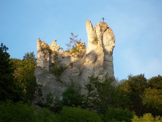
The castle ruin Neugutenstein is the ruin of a medieval hilltop castle near Gutenstein, a district of Sigmaringen in the Sigmaringen district, Tübingen administrative region, Baden-Württemberg.
It is located in the Danube valley near the confluence of the Schmeie coming from the north, above the road from Sigmaringen to Beuron, between Inzigkofen station and Inzigkofen-Dietfurt. The castle is a typical rock needle castle, a special form of rock castle, which was built storm-proof at around 660 meters above sea level on an isolated rock needle on the left valley edge of the Upper Danube Nature Park. The Danube has its bed at around 577 meters above sea level.
The castle - initially also called Niedergutenstein - was first mentioned in a document in 1354. At this time, it was held as a fief of Duke Albert of Austria by Burkhard von Reischach.
The time of the castle's construction and its builders are not conclusively clarified. Due to the naming and the relatively late first documentary mention, it is generally still assumed today that the castle was built by Gutenstein at the beginning of the 14th century.
In 1377, Duke Leopold III of Austria pledged the castle to Ulrich von Stüben. In 1410, the Lords of Stüben acknowledged receipt of 1500 fl. from Stefan von Gundelfingen for the redemption of the pledged property. The castle was already referred to as a ruin (Burgstall) at this time.
Through purchase, the ruin came into the possession of the Counts of Sonneberg in 1509 and, around 1530, through marriage, to the Imperial Hereditary Seneschals of Waldburg zu Scheer. In 1659, they exchanged the "Gundelfinger Gut" area with the "Prochen Guettebstein" ruin for the so-called Faulbronner Forest with Laiz Monastery. In the corresponding document, the ruin is first referred to as "Gebrochen Gutenstein" (cf. Gutenstein).
It was then for a time in the possession of Gebhard Xaver, Eberhard Ernst, and Josef Alois, all Seneschals of Sigmaringen, and passed to Prince Karl Friedrich von Hohenzollern-Sigmaringen in 1783.
Layout+
The medieval castle complex is divided into two parts: the main castle built on a rock and the farmyard on the adjacent plateau. The main castle consisted of two sections: the residential tower and the lower castle. Remains of the residential tower on the rock needle are particularly well preserved from the complex.
The presumably Gothic window or archway, which was clearly visible from the Danube Valley Road for decades, was presumably brought down by a storm in mid-January 2008. The still-preserved wall is about eight meters high and twelve meters long.
Take Mobile History with you
You are reading this text for free. Premium adds what matters on the road: descriptions read aloud, sites found through your camera, whole regions taken offline.
- Every description, including the ~17,700 Premium sites
- Audio guide: have descriptions read to you on location
- AR finder: see sites through your camera, with distance and bearing
- Unlimited saved sites
14 days free, then from €2.99 a month. Cancel anytime.
Source: Wikipedia · Licence: CC BY-SA 4.0 · Image: Peter Schneider
This description draws on the facts documented in the linked Wikipedia article; Wikipedia content is licensed under CC BY-SA 4.0. Wording and editing: Mobile History.
Location: 48.0802, 9.1569