The remains of the Castle can be visited
CastleNeckargerach-Guttenbach
Minneburg Castle
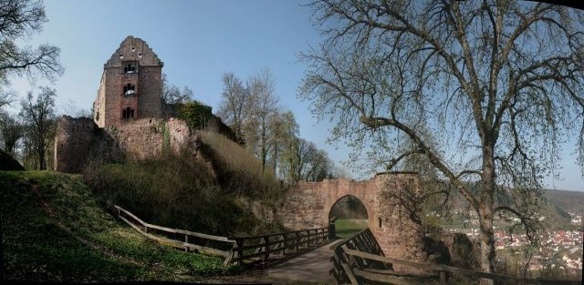
Minneburg is the ruin of a hilltop castle in the Neckar Valley, located in the municipal forest area of Neckarkatzenbach in the Neckar-Odenwald district of Baden-Württemberg. The castle overlooks Neckargerach, situated directly on the opposite side of the Neckar, and was historically closely linked to Guttenbach, a district at the foot of the castle hill (Schlossrücken).
The origins of Minneburg are obscure. It was probably built by Staufer ministeriales, and its creation is connected with the Staufer imperial palace in Bad Wimpfen and other related castles in the Neckar Valley. Its first historically confirmed mention dates to 1339, when Eberhardt Rüdt von Collenberg acquired the castle and its associated lands, including the villages of Guttenbach and Neckarkatzenbach, through marriage. Already in 1349, he sold it to Ruprecht I of the Palatinate. The Electoral Palatinate pledged the castle several times to the regional lower nobility, including the Lords of Gemmingen. The castle fief also included the Leidenharterhof, located northwest of the castle.
In 1518 (or 1521), Minneburg became a hereditary fief of the Heidelberg Vogt Wilhelm von Habern, who was responsible for the reconstruction into the current form of the core castle with its representative palas and the expansion with the mighty fortifications including defensive towers and the outer bailey. About a year after the transfer of ownership, at least parts of the fortifications are said to have been completed. The master builder was a Hans Steinmüller from Wertheim, who was in great demand at that time as a specialist in fortifications in Southern Germany.
The construction of the water supply also falls into this period at the latest. Water was led from a spring above the castle, via a wooden pipeline, across the neck ditch, where a supporting pillar can still be seen today, into the interior of the castle. A niche in the old shield wall served as a water reservoir.
With Wilhelm's sons, the Habern line died out around 1600, and the castle became an Electoral Palatinate cellarage. During the Thirty Years' War, the castle was besieged by Tilly's troops. They eventually breached the fortifications, and on March 22, 1622, the partially destroyed castle was surrendered. Afterwards, it was used as a quarry by the local population. Around 1648, Johann Sigmund Seyfried was responsible for the cellarage and at the same time the first known official in the function of a Zentgraf for the Schwarzach-Minneburg sub-district of the Stüber Zent. The cellarage moved to the neighboring Schwarzach Castle in 1663 and retained its sub-district importance until the Electoral Palatinate was largely incorporated into the Grand Duchy of Baden in 1803.
In the early 19th century, the castle ruin was inhabited by the hermit Andreas Hilberle († March 7, 1819), who earned his living by making wooden clockworks and around whom a legend, first published in 1919, revolves.
At the end of the 19th century, the first renovation measures were carried out on the ruin, but it subsequently fell into disrepair again. Since about 1970, the ruin has been further secured.
Layout+
Minneburg is situated on an outcrop of the Schlossrücken, about 50 meters above the Neckar Valley. Southeast below the castle, on the banks of the Neckar, lies the village of Guttenbach. Directly opposite the castle on the other side of the Neckar, to the northeast, lies Neckargerach. The complex is separated from the Schlossrücken, which continues to rise to the northwest, by a neck ditch.
The oldest part of the complex is the core castle, forming an irregular pentagon, consisting of a palas, a so-called kitchen building, a shield wall, and a keep, with the keep presumably being the earliest of these. The shield wall is separated from the keep by a construction joint, so the wall either originated after the keep or replaced an older wall built at the same time as the keep. The originally Gothic palas was extended with a stair tower and provided with oriels and decorative gables during the Renaissance period under Wilhelm von Habern.
Around the core castle, also under von Habern at the beginning of the 16th century, the massive fortification (zwinger) was built, whose wall on the mountain side was particularly high and thick and which has massive gun towers to the north, south, and west. On the valley side, the generously laid out outer bailey with economic buildings resting on massive stone foundations was also built. Access to the castle was through the southeast castle gate with a drawbridge, through which one first entered the inner courtyard of the outer bailey, from which a steeply rising path leads to the core castle. Although the significant extensions and alterations only took place in the 16th century, Minneburg, due to its defiant new walls and towers, still presented the image of a medieval castle and not – as often elsewhere – that of a Renaissance palace.
While today the outer bailey is almost completely removed except for a few wall and foundation remnants, the buildings of the core castle and the surrounding walls and gun towers have been secured and partially restored. The complex is publicly accessible and can be fully visited at any time.
Legend+
According to a legend, the castle is named after Minna von Horneck. She was to be married to the Count of Schwarzenberg but fled to a cave near the present-day Minneburg because she loved the poor knight Edelmut von Ehrenberg and was waiting for his return from a crusade. When he actually returned, Minna was already dying. At her deathbed, he is said to have promised to build a castle and named it Minneburg in memory of their great love (Middle High German: Minne).
Take Mobile History with you
You are reading this text for free. Premium adds what matters on the road: descriptions read aloud, sites found through your camera, whole regions taken offline.
- Every description, including the ~17,700 Premium sites
- Audio guide: have descriptions read to you on location
- AR finder: see sites through your camera, with distance and bearing
- Unlimited saved sites
14 days free, then from €2.99 a month. Cancel anytime.
Source: Wikipedia · Licence: CC BY-SA 4.0 · Image: Bernd Walter
This description draws on the facts documented in the linked Wikipedia article; Wikipedia content is licensed under CC BY-SA 4.0. Wording and editing: Mobile History.
Location: 49.3966, 9.0646