The remains of the Castle can be visited
CastleMühlhausen-Ehingen
Mägdeberg Castle
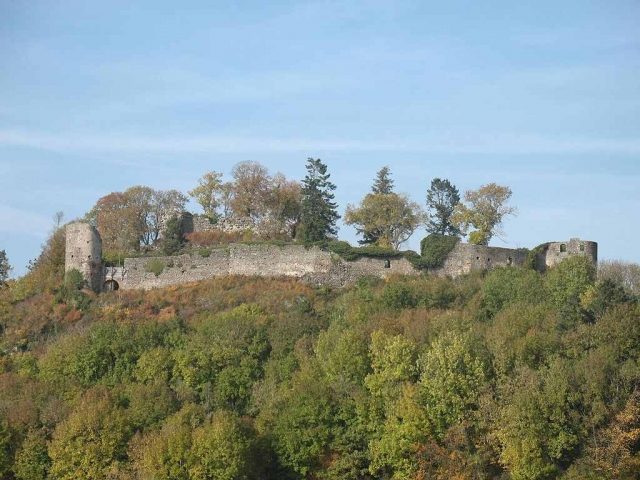
Mägdeberg Castle is a medieval castle ruin located 1.5 kilometers southwest of Mühlhausen-Ehingen in the district of Konstanz in Baden-Württemberg, Germany.
The castle, situated on the forested Mägdeberg in Hegau, is a type of hilltop castle. The ruin stands at approximately 654 meters above sea level and is strategically located, surrounded by other castles. In the immediate vicinity of Mägdeberg Castle, about two kilometers southeast, is Hohenkrähen Castle, and five kilometers to the northwest near Engen, i.e., within sight, is Hohenhewen Castle. Access to the now overgrown Mägdeberg ruin is via Mühlhausen. A hiking car park is located about 300 meters from the ruin.
The founding of the castle by Reichenau Abbey is dated to the year 1235. Between 1235 and 1240, at the behest of the abbot of Reichenau Monastery, the mountain and a chapel located on it were expanded into a defensive complex. In 1240, the castle was first mentioned in a document as castrum Megideberc.
From 1337, the Reichenau ministerial family of Dettingen resided in the castle, which they acquired as collateral around 1343, along with other castles. Around this time, the Counts of Württemberg and the Dukes of Austria also appeared as interested buyers. The castle was the object of dispute, as both intended to expand their position in Hegau.
In 1358, Abbot Eberhard von Brandis (1343-1379) sold the castle to the Habsburgs, Dukes Rudolf IV, Friedrich III, Albrecht III, and Leopold III of Austria. About three months later, in 1359, Counts Ulrich IV and Eberhard II of Württemberg acquired Mägdeberg Castle, a highly curious situation as the castle apparently went from two sellers to two buyers simultaneously. However, the Württemberger managed to establish himself in the castle more quickly. But since the Habsburgs needed Württemberg's support, the illegal second sale to the Counts of Württemberg initially remained without consequences.
In 1378, due to a long-standing feud between the Württemberg counts and the Upper Swabian cities, the castle was destroyed by troops of the Upper Swabian League of Cities. The castle was besieged by Konstanz troops, whereupon 18 farmers from Mühlhausen deserted, and the rest of the garrison soon after also surrendered. This was one of the first sieges in Hegau with large firearms. The captured castle was subsequently plundered and razed.
For over 100 years, the Mägdeberg ruin lay fallow until it was rebuilt in 1479 by Count Eberhard im Bart. From Mägdeberg, he besieged the neighboring Hohenkrähen Castle, as he was in a feud with its lords. Now the illegal sale of 1359 took its revenge. Around the same time, Sigmund of Austria laid claim to Mägdeberg Castle, insisting on the invalid purchase of 1359. When he failed, the Austrian had an army of 3400 men march before the castle. Among them were over a thousand infantrymen and 400 cavalrymen. After a good ten days, the siege without combat ended, and the castle was surrendered. Around 1480/81, Eberhard im Bart finally renounced the castle entirely, and it came into the possession of Austria.
In 1485, the castle ruin was rebuilt and fortified at the expense of the Archduke of Austria. After the completion of the expansion around 1500, the castle was granted by Austria as a pledge and fief.
During the German Peasants' War in 1525, the castle was occupied by local peasants but not destroyed. In 1528, it passed as a fief to the Lords of Reischach.
In 1633, the castle, which already had a fortress character, was captured and plundered by Swedish and Württemberg soldiers during the Thirty Years' War (1618-1648).
In 1634, Konrad Widerholt, the commander of Hohentwiel Fortress, had Mägdeberg and Hohenkrähen castles burned down to prevent them from offering refuge to potential enemies of Hohentwiel Fortress.
The third reconstruction of the castle took place between 1650 and 1653. This was more of a makeshift repair. In 1657, the castle passed as a fief to the Lords of Rost.
In 1700, the complex was in such a poor state that it was abandoned. In 1710, the demolition of the castle began.
In 1774, it passed as a fief to the Counts of Enzenberg.
Between 1820 and 1830, the roof of the Ursula Chapel, which had been in use until then, collapsed. It was dissolved in 1788.
In 1840, the castle ruin came into the possession of the Countess of Langenstein, whereupon Mägdeberg became the property of the Counts Douglas of Langenstein in 1872 and has remained so to this day.
Construction Description+
The castle complex is freely accessible. The ashlar masonry is completely enclosed and in good condition, so that the form and dimensions of the former castle have largely been preserved. The remains indicate an impressive defensive complex, which, however, was by no means as impregnable as Hohentwiel Fortress. Mägdeberg Castle was destroyed a total of three times until the 17th century. After its abandonment at the end of the 17th century, the castle was dismantled and used as a quarry.
The fortress structure is divided into an upper castle (main castle) and a lower castle (outer bailey). It illustrates the construction methods of various periods of the Middle Ages. The summit castle dates from the High Middle Ages. The round gun towers were built in the Late Middle Ages.
Access to the castle was from the east through the first castle gate (?). A gently sloping ramp-like ascent, supported by a wall to the south, led to the second castle gate. Its left side was flanked by a mighty shell tower. The castle gate had to be supported by a wooden structure as it threatened to collapse. To the right is the zwinger. In front of the upper gatehouse is a large forecourt. In the third castle gate, in the two-story and thick-walled gatehouse to the main castle, stood the last used building, the Ursula Chapel, until its roof collapsed. The main castle itself stands on natural rock. In the main castle are the remains of the palas.
Take Mobile History with you
You are reading this text for free. Premium adds what matters on the road: descriptions read aloud, sites found through your camera, whole regions taken offline.
- Every description, including the ~17,700 Premium sites
- Audio guide: have descriptions read to you on location
- AR finder: see sites through your camera, with distance and bearing
- Unlimited saved sites
14 days free, then from €2.99 a month. Cancel anytime.
Source: Wikipedia · Licence: CC BY-SA 4.0 · Image: https://commons.wikimedia.org/wiki/File:Ruine_Maegdeberg.JPG
This description draws on the facts documented in the linked Wikipedia article; Wikipedia content is licensed under CC BY-SA 4.0. Wording and editing: Mobile History.
Location: 47.8057, 8.7978