The remains of the Castle can be visited
CastleBad Zwesten-Oberurff-Schiffelborn
Löwenstein Castle
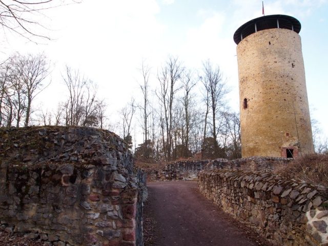
The former Löwenstein Castle, near the Oberurff-Schiffelborn district of the municipality of Bad Zwesten in North Hesse, exists today as a partially reconstructed ruin of a hilltop castle at 341 m above sea level, dating from the early 13th century, which has been in decay since the 17th century.
Construction and Form+
First documented in 1253, the castle was completed in 1236 by Werner II von Bischoffshausen, who held it as a fief from the Landgraves of Thuringia. Around 1250, he was appointed regional judge in Lower Hesse by Heinrich III von Meißen, the new Wettin Landgrave of Thuringia, and thereafter, along with Konrad von Elben, was one of the most important supporters of Duchess Sophie of Brabant in her struggle for the Landgraviate of Hesse for her son Heinrich. Werner was married to Gertrud von Itter, a daughter of Heinrich von Itter, called Pampis. In her honor, he named the castle "Löwenstein" (Lion Stone), as Gertrud bore the Itter lion in her coat of arms. Their descendants named themselves after the castle.
In its final form in the 14th century, the complex consisted of a spacious outer bailey and the slightly higher main castle with five manor houses, a chapel first mentioned around 1300, and a 26-meter-high keep. The high entrance to the keep was at a height of 7 m, accessible via a drawbridge from a neighboring residential building, which no longer exists today. The guardroom was located in the access area. Below it, in the tower area, was a windowless dungeon. Above the guardroom, two rectangular residential floors were added. In the outer bailey were the forge, bakery, brewery, stables, and other utility buildings. A 450 m long and heavily fortified curtain wall enclosed the entire complex. A moat surrounded the entire castle, and in front of it was another protective earth rampart. Service water was brought to the castle by pack animals via the so-called donkey path from the nearby Urff river.
At the foot of the castle lay the settlement of Schiffelborn.
The founding family was first documented in 1160 when they still lived in "Biscopehusen" (today's Bischhausen). They then moved to the strategically favorable Ortberg, above the Löwenstein valley, through which the old trade route from Kassel to Frankfurt ran. During the Thuringian-Hessian War of Succession, which began in 1247, Wernher II von Bischofhausen managed to gain considerable influence in North Hesse by taking an early side with Duchess Sophie of Brabant and her minor son Heinrich, as Sophie appointed him temporary governor of the region. This made it necessary to expand the family seat on the Ortberg in a manner befitting their status.
With the sons of Wernher and Gertrud, the family divided into three lines. Heinrich, after his marriage to Giesela von Schweinsberg, called himself "von Löwenstein-Schweinsberg"; Werner, after his marriage to Guda von Westerburg, "von Löwenstein-Westerburg"; and Hermann, after his marriage to Hedwig von Romrod, "von Löwenstein-Romrod". Bruno, the fourth son, became a canon in the St. Petri collegiate church in Fritzlar. However, the three lines remained joint owners of the castle as co-heirs, inhabited it together well into the 14th century, and extensively expanded it. The Löwenstein-Westerburg line died out in 1492, and the Löwenstein-Schweinsberg line in 1660.
In the conflicts of this period between the Archbishopric of Mainz and the Hessian Landgraves, the Löwensteiners acted very flexibly. They opened their castle at various times to each of the two parties, as well as to the Counts of Waldeck, and thus maintained good relations with all sides. Despite its excellent defensive capabilities, the castle was more of an administrative castle. Contracts were concluded there, and decrees and laws were passed.
The castle's location was ideally suited for monitoring the trade route from Kassel to Frankfurt, the Salt Road. Later castle lords used this location for highway robbery and brigandage. For example, Johann von Löwenstein is documented with his raids in 1439. This was a clear decline compared to the ancestral generation of the castle builder Wernher. However, it may be that the brigand Johann felt compelled to his misdeeds because the Löwensteiners had sided with the defeated Mainz party in the decisive battle near the nearby Kalbsburg in 1427 during the Mainz-Hessian War, thereby largely losing their legitimate sources of income and having to provide for themselves otherwise.
Decline+
With the advent of firearms, the castle lost its strategic value. Towards the end of the 16th century, the castle lords moved to their estates in the surrounding area, and the castle began to decay. Already in 1579, parts of the walls had collapsed. Hieronymus von Löwenstein renewed the curtain wall between 1596 and 1600, but by 1602 the castle was already partially a ruin. After further destruction in 1635 by imperial troops in the Thirty Years' War, it was only used as a quarry for building construction in the surrounding villages. The castle inhabitants settled on surrounding estates. In 1710, the last service was held in the castle chapel; the village of Schiffelborn at the foot of the castle had about 20 households at that time.
Current State+
The keep remained largely preserved and was renovated in the 1930s and again in 2002, and has since been accessible to the public as an observation tower. It offers a remarkable view over the Löwenstein valley, the Schwalmpforte, and into the Kellerwald-Edersee National Park region. The buildings and outer wall are still partially preserved as walls about one meter high. The moat still surrounds almost the entire complex today. Excavation work is carried out depending on the availability of financial resources.
Take Mobile History with you
You are reading this text for free. Premium adds what matters on the road: descriptions read aloud, sites found through your camera, whole regions taken offline.
- Every description, including the ~17,700 Premium sites
- Audio guide: have descriptions read to you on location
- AR finder: see sites through your camera, with distance and bearing
- Unlimited saved sites
14 days free, then from €2.99 a month. Cancel anytime.
Source: Wikipedia · Licence: CC BY-SA 4.0 · Image: http://www.wehrbauten.de/thread.php?threadid=1367
This description draws on the facts documented in the linked Wikipedia article; Wikipedia content is licensed under CC BY-SA 4.0. Wording and editing: Mobile History.
Location: 51.0400, 9.1493