The remains of the Castle can be visited
CastleLöwenstein
Löwenstein Castle
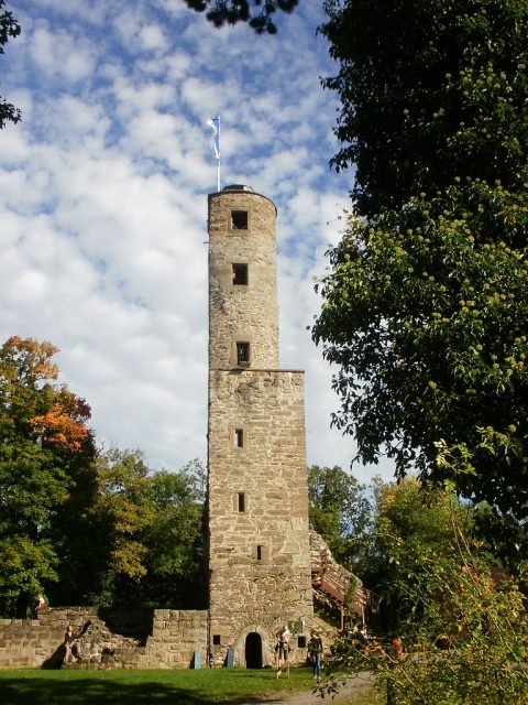
Löwenstein Castle is the ruin of a medieval castle above the town of Löwenstein in the district of Heilbronn. The name derives from the heraldic animal of the original builders, the Counts of Calw, and was then transferred to the adjacent locality.
The castle ruin of Löwenstein rises about 13 kilometers east-southeast of Heilbronn at 427 m above sea level. About 150 meters southeast of the town center of Löwenstein, which lies 42 meters lower, it watches over the Sulm valley, which lies about 230 meters deeper, from a prominent spur position on the Keuper edge of the Swabian-Franconian Forest Mountains natural region. By constructing a neck ditch, still about nine meters deep today, the castle lords separated the spur of the castle grounds from the narrow, only slightly rising eastern foothills of the Löwenstein Mountains, which reach heights of almost 550 m above sea level a few kilometers behind the castle.
The Counts of Calw probably built a first castle at this location in the late 11th century (around 1080 to 1090, under Adalbert II of Calw) at the descent of the Salt Road from Schwäbisch Hall to Heilbronn from the plateau of the Swabian-Franconian Forest Mountains. As early as 1133, the castle was attacked and partially destroyed by Welf VI due to inheritance disputes, but was later restored and expanded in the 12th century.
After the Calw family, the castle, along with the County of Löwenstein, passed into Habsburg possession. During the visit of King Rudolf I in 1287, the adjacent locality of Löwenstein received town rights. In the first half of the 14th century, the castle was probably expanded with the first curtain walls, and the town wall of Löwenstein was also built, whose wing walls extended up to the castle.
In the late 14th century, Löwenstein Castle and town increasingly came under the influence of the Electoral Palatinate. Half of the town and castle were pledged to Elector Ruprecht I in 1382, and in 1394 and 1399 the Löwenstein counts concluded castle peace treaties with Ruprecht's successors. Political tensions arising from this with the Lords of Weinsberg and the House of Württemberg, whose territories bordered, gave rise to construction measures in the early 15th century. In 1441, the Electoral Palatinate finally acquired the entire County of Löwenstein, including the castle. The Palatine Counts, who at that time pursued an aggressive policy against Württemberg, then pushed for the further massive expansion of the complex in the late 15th century.
The ongoing conflicts between the Palatinate and Württemberg finally led to the conquest of the castle by Duke Ulrich of Württemberg in 1504. Parts of the castle were destroyed in a fire in 1512; from the late 16th century onwards, it fell into disrepair.
Building material from the remains of the castle was then used for the construction of a new castle complex in Löwenstein, for the town and cemetery wall, and in the town church from 1760.
The first extensive safeguarding and restoration work took place from the 1970s onwards.
Complex+
The core castle, built at the end of the 11th century, covers an area of about 500 m² and, in its original form, corresponds to the type of polygonal roundel. Against the attack side, the ring wall in the east is flattened and reinforced into a shield wall. The walls are made of local sandstone ashlar, in the southern part of the ring wall they are still attributed to the Salian period. The preserved bossed ashlar of the shield wall, the keep, and the palas are Staufer. Whether the castle complex was structurally expanded for the first time after the partial destruction in 1133 or merely restored cannot be concluded with certainty from the findings. At the end of the 15th century, the castle was expanded with a Zwinger (outer bailey) complex with a gatehouse and casemate tower.
Salian-Staufer Core Castle
Attacks on the castle were most likely to be expected from the narrow ridge in the east. Here, parallel to the neck ditch, rose the straight shield wall of bossed ashlar masonry, up to 10.20 meters high, 1.84 meters thick, and at least 24 meters long. Today, it is best preserved in the area of the stair tower, which is connected to it by butt joints.
The 24-meter-high stair tower is the only building of the castle complex that is almost completely preserved. It is divided into an upright cuboid about 13 meters high, on which an approximately eleven-meter-high and significantly slimmer segment sits "most idiosyncratic in form and character ... about three-quarters round" (Dähn). Five meters above the level of the castle courtyard, on the south side of the stair tower, is its Gothic-designed high entrance. The stair tower has openings on all sides at different heights; on the north side, these were originally passages to the keep. In the ground floor of the stair tower is a dungeon with its own access and murder hole.
The stair tower provided access to the keep, which was built to the north and whose east wall was also part of the shield wall. All wall sides of the keep are preserved at the height of the dungeon and are consistently as thick as on the shield wall side. Externally, it measures 5.98 meters (east-west) by 5.92 meters (north-south), thus internally 2.30 meters by 2.24 meters.
The exact location of the other buildings of the first construction phase is not completely secured. Based on the illustration of Gadner's forest map from 1594, which shows a large residential building, Dähn assumes that the former palas was located in the south of the core castle; he estimates its external dimensions to be a rather modest 18 meters by 7 meters.
Remains of the inner, old castle gate on the unthreatened west side of the castle are not preserved. Dähn deduces its position from the later layout of the castle bailey and a partially preserved casemate tower.
Palatine Castle Expansion
In the late 15th century, the castle lords took into account developments in weapon technology and reinforced the castle all around with a largely still preserved outer bailey system, bringing it to a total area of around 3500 m². In the western bailey area, a strongly fortified two-story gatehouse with a firing chamber, flanking tower, and posterns was also erected. A new building, modeled on the Renaissance style, was built on the ruins of the gatehouse; instead of the original gabled roof, a walled terrace was set up on the ceiling of the upper floor.
Traces of further buildings were excavated in the northeastern castle area; these were probably smaller residential and utility buildings (Kasten).
Current Use+
From early March to late October, the panoramic tower is open on weekends and public holidays. From its pulpit, with good long-distance visibility, one can recognize the prominent points of the Katzenbuckel in the Odenwald, the Königstuhl on the Bergstraße, and Steinsberg Castle in Kraichgau. On opening days, there are free short guided tours of the castle grounds, and the snack bar at the castle is then open.
In the castle forest, artworks along the hiking trails create a romantic ambiance. The castle is also an attraction for followers of the LARP scene.
Take Mobile History with you
You are reading this text for free. Premium adds what matters on the road: descriptions read aloud, sites found through your camera, whole regions taken offline.
- Every description, including the ~17,700 Premium sites
- Audio guide: have descriptions read to you on location
- AR finder: see sites through your camera, with distance and bearing
- Unlimited saved sites
14 days free, then from €2.99 a month. Cancel anytime.
Source: Wikipedia · Licence: CC BY-SA 4.0 · Image: https://commons.wikimedia.org/wiki/File:Burg_L%C3%B6wenstein_im_Herbst_2010.JPG
This description draws on the facts documented in the linked Wikipedia article; Wikipedia content is licensed under CC BY-SA 4.0. Wording and editing: Mobile History.
Location: 49.0930, 9.3831