The remains of the Castle can be visited
CastleSchirgiswalde-Kirschau
Körse Castle
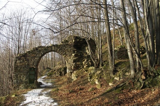
Körse Castle is the ruin of a hilltop castle at 275 m above sea level on a granite cone surrounded by the Spree near Kirschau in the district of Bautzen in Saxony.
When the Slavic settlement area was extended into the region of present-day Kirschau around the 10th century, the rocky spur was used to build a defensive structure, a redoubt. The castle wall, named Korzym (Korz's property), had the task of protecting the settlement area from surprise attacks.
Around 1100, the German conquest of land began, during which they occupied and destroyed the castle. Between 1200 and 1250, a stone German fortification was built on the same site. During this time, the castle, whose name Körse refers to its Sorbian origin, was the largest and strongest defensive structure in Upper Lusatia.
Its task was to protect the Bohemian Trail, one of the oldest transport links between Upper Lusatia and Bohemia (known there as the Old Prague Road). It led from Bautzen via Obergurig, Kirschau, Schirgiswalde and Sohland to Schluckenau (Šluknov), Böhmisch Leipa (Česká Lípa) to Prague. In addition, a salt road, which also had to be guarded, crossed nearby.
Later, however, the castle lords were accused of robbery, so in 1352 the castle was stormed and destroyed by troops of the Lusatian League. An information board in the remains of the present complex claims that the castle lords were declared enemies rather because of their opposition to the Bohemian king and the Lusatian League.
In 1359, the castle was again destroyed and razed. No reconstruction took place.
Structure+
The castle consisted of the main castle with a keep, an outer bailey, a drawbridge, as well as four gates and bastions.
The local granite was used for construction, but also basalt from the Horken near Halbendorf. Sand mortar, mixed with washed and humus acid-free river sand, served as a binder. The curtain wall surrounding the former castle courtyard is still about three meters high. It is said to have once been six to seven meters high.
Present Day+
What remains of the once proud castle is a semicircular curtain wall, about 3 meters high and about 100 meters long, which represents the remains of the main castle. In addition, the archway of the outer bailey can be seen.
The granite stones inside the ring wall suggest fire damage during the siege and storming of the castle.
The first excavation work began in 1922, and the artifacts unearthed in the subsequent period can be seen in the castle museum, which opened in 1995.
Take Mobile History with you
You are reading this text for free. Premium adds what matters on the road: descriptions read aloud, sites found through your camera, whole regions taken offline.
- Every description, including the ~17,700 Premium sites
- Audio guide: have descriptions read to you on location
- AR finder: see sites through your camera, with distance and bearing
- Unlimited saved sites
14 days free, then from €2.99 a month. Cancel anytime.
Location: 51.0889, 14.4300