The remains of the Castle can be visited
CastleKantara (Καντάρα)
Kantara Castle
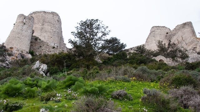
Kantara Castle Ruin, an imposing medieval fortress, is perched at an altitude of approximately 604 meters in the Pentadaktylos Mountains in northeastern Cyprus. It stands as a silent witness to a turbulent history, offering expansive views over the island, the northern coast, and the Mesaoria plain from its elevated position.
History+
The castle's origins date back to the 10th century, when it served as a Byzantine observation post against Arab invaders. In the 12th century, it was expanded into a significant fortress. Its role in history was particularly highlighted in 1191, when the Cypriot Emperor Isaac Komnenos sought refuge here from Richard the Lionheart, who conquered Cyprus on his way to the Third Crusade. After a siege, Isaac Komnenos was forced to surrender. Later, in May 1192, Richard sold the island to Guy of Lusignan, who thus became the first ruler of the Kingdom of Cyprus. During conflicts between the supporters of Frederick II and King Henry I of Cyprus in 1229, Gauvain de Chenichy entrenched himself in Kantara but later had to abandon the castle. Even a reconquest by the loyalists of Frederick II in 1232 was not lasting. Despite the Genoese conquest in 1373, Kantara remained in the possession of the Lusignans. The ruins visible today likely stem from renovations carried out in 1391. Although the Venetians recognized the castle's strategic importance, it was already in ruins by 1562.
Location+
Kantara Castle Ruin is located near the village of Kantara in the Gazimağusa district of Northern Cyprus, part of the island of Cyprus. It stands at an elevation of approximately 604 meters above sea level.
On site+
Today, Kantara Castle Ruin is accessible to visitors and can be explored, offering insight into its historical significance.
Nearby+
- Ancient City of Salamina (Ancient Buildings), approx. 24.6 km away
- St. Barnabas Monastery (Sacred Building), approx. 26.0 km away
- Ancient City of Enkomi (Ancient Buildings), approx. 27.1 km away
- Famagusta-Martinengo Bastion City Walls (City Fortification), approx. 30.9 km away
Take Mobile History with you
You are reading this text for free. Premium adds what matters on the road: descriptions read aloud, sites found through your camera, whole regions taken offline.
- Every description, including the ~17,700 Premium sites
- Audio guide: have descriptions read to you on location
- AR finder: see sites through your camera, with distance and bearing
- Unlimited saved sites
14 days free, then from €2.99 a month. Cancel anytime.
Source: Wikipedia · Licence: CC BY-SA 4.0 · Image: Google Hupf
This description draws on the facts documented in the linked Wikipedia article; Wikipedia content is licensed under CC BY-SA 4.0. Wording and editing: Mobile History.
Location: 35.4064, 33.9233