The remains of the Castle can be visited
CastleIsenburg
Isenburg Castle
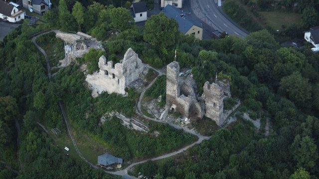
The ruins of Isenburg Castle, the ancestral home of the Isenburg family, are located in the Rhineland-Palatinate village of Isenburg in the Westerwald.
The hilltop castle is situated approximately ten kilometers as the crow flies northeast of the Rhine cities of Neuwied and Bendorf, and southwest of the small Westerwald town of Dierdorf. It stands on a mountain spur about 250 meters high above the village of the same name, at the confluence of the Ommelsbach, Wiebelsbach, and Iserbach with the Saynbach.
Isenburg Castle is first mentioned in a document from 1103 by Archbishop Bruno of Trier. The brothers Reinbold and Gerlach von Isenburg, named in this document, are first mentioned by Archbishop Poppo of Trier in 1041 and 1042 in documents concerning the possession of the St. Simeon Monastery in Hönningen.
The castle was probably built around 1100 by Reinbold and Gerlach von Isenburg in the territory of a manor belonging to Fulda Abbey as their ancestral seat. Due to the very early branching of the family into several lines, it very soon acquired the character of a Ganerbenburg, meaning a castle community of members from different family branches, usually related to each other.
In 1625, the castle was still inhabited. At that time, it primarily served as a widow's residence. In 1633, it was occupied by Spanish troops but not destroyed. With the death of Count Ernst von Isenburg-Grenzau in 1664, the Nieder-Isenburg line died out. Due to an inheritance dispute, the castle subsequently fell into disrepair. From 1666, the Counts of Walderdorff and the Counts of Wied-Neuwied (transferred to the Counts of Wied-Runkel in 1694) became the territorial lords as part of a condominium. The castle ruins today belong to the Prince of Wied in Neuwied.
In 1771, the southern half of the keep, along with the staircase, collapsed. Fearing that the rest of the tower might one day fall onto the village, it was considered to shoot it down with cannons or blow it up. Finally, these plans, as well as the idea of dismantling the ruins by hand, were abandoned due to the danger and cost, in the hope that the wall would remain standing for another 50 years.
According to Isenburg municipal accounts from 1783 to 1810, the ruins served as a quarry.
Since 2005, the "Freundeskreis der Isenburg e.V." (Friends of Isenburg Association), in conjunction with the "Landesamt für Denkmalpflege Rheinland-Pfalz" (Rhineland-Palatinate State Office for Monument Preservation), has been working to preserve the castle ruins for posterity and to make them fully accessible to the public again.
Castle Complex+
Isenburg Castle is a Romanesque hilltop castle and was very generously and spaciously laid out. It is the second oldest castle in the Neuwied district. The steep hilltop on which it was built is surrounded on three sides by the Saynbach and Iserbach and connected to the Ebenfelder Höhe in the north by a narrow saddle.
Its extent was approximately 70 meters in north-south direction and about 30 meters in east-west direction. It was separated into a northern and a southern part by a transverse wall. The keep was not, as usual, on the attack side (in the north), but in the southwest corner on a rock spur. From here, the Sayn Valley could be well monitored in both directions. Its floor plan is a square with sides of 9 meters. Above the strongly 2-meter-thick masonry of the vaulted basement, parts of the north and east walls of the second and third floors still rise. The tower must have had a height of 20 to 25 meters. The still visible high entrance at about 6 meters height led to the first upper floor; below it, there was a round-arched entrance also to the basement.
In the 13th century, there were four residential houses here: the Isenburg or old house, the Kobernhaus, the Haus Wied, and the Frauen- or Runkelsche Haus. The Frauenhaus was also referred to as Haus Grenzau. The keep, gates, and bridges were used jointly. Of these houses, especially on the west side, wall remains, some over 10 meters high, with gables, windows, consoles, etc., are still preserved. Under the largest, apparently burned-down house, there was a barrel-vaulted cellar, which largely collapsed only in the 1930s.
Fortification of the Castle Hamlet+
The settlement at the foot of Isenburg Castle was a castle hamlet of the same name and had town rights or the status of a privileged place. However, a town foundation did not materialize, as the valley location of the place offered no possibilities for expansion.
Already at the beginning of the 14th century, the castle hamlet was fortified. The fortification extended in a considerable radius around the castle and valley and not only protected the village but also served the castle as an advanced security. It consisted of a wall and a ditch, partly perhaps only of dense thickets, and had four gates. One of the gates, the Alte Porz (Old Gate), located in the village center directly on the B 413, is still one of Isenburg's landmarks today and has housed a local history museum since 2008. It was built as an outer protective gate at the castle ascent. This gatehouse has a pointed-arched gate opening, which, covered by beams, supports a half-timbered structure whose gable roof is adorned with a small bell tower. On one side, the stump of what was probably an original round tower, built of rubble stone, leans against it. Possibly, such a tower was also present on the opposite side. An attached half-timbered house probably served as the dwelling for the guards. This gatehouse was restored in 1959 and is in good structural condition. The second gate is the Schildpforte (Shield Gate) above the cemetery near the parish church, on the old path over the Ebenfeld to Kleinmaischeid. It is still almost in its original state. It is a square tower with sides of 4.5 meters and a height of 9 meters. It was three-storied and has a pointed-arched gate opening.
Take Mobile History with you
You are reading this text for free. Premium adds what matters on the road: descriptions read aloud, sites found through your camera, whole regions taken offline.
- Every description, including the ~17,700 Premium sites
- Audio guide: have descriptions read to you on location
- AR finder: see sites through your camera, with distance and bearing
- Unlimited saved sites
14 days free, then from €2.99 a month. Cancel anytime.
Source: Wikipedia · Licence: CC BY-SA 4.0 · Image: http://commons.wikimedia.org/wiki/File:Isenburg_-_Burg_Isenburg.jpg?uselang=de
This description draws on the facts documented in the linked Wikipedia article; Wikipedia content is licensed under CC BY-SA 4.0. Wording and editing: Mobile History.
Location: 50.4762, 7.5911