The remains of the Castle can be visited
CastleDortmund -Syburg
Hohensyburg Castle
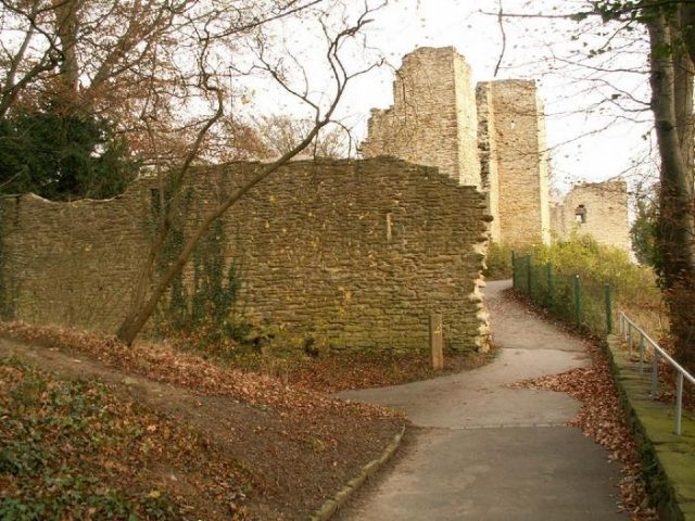
The Hohensyburg, also known as Sigiburg or Syburg, is located on the Syberg above the confluence of the Ruhr and Lenne rivers into the artificially created Hengsteysee in the southern Dortmund district of Syburg. The Hohensyburg is today a popular excursion destination. Nearby is the Hohensyburg Casino. The surrounding area is designated and protected as the Ruhrsteilhänge Hohensyburg nature reserve. The Syburger Bergbauweg (Syburg Mining Trail) opens up relics of modern mining.
Origins+
Stone Age finds prove the early presence of humans in the Syburg area, and the first traces of settlement date back to the Bronze Age around 700 BC. The first documented mention is for the year 775, when, according to the Lorsch Annals, Charlemagne's Frankish army conquered the Saxon Sigiburg and in turn used it as a defensive structure against the Saxons. The Saxon territory at that time was not identical to today's. The Falen were a Saxon tribal group that had its settlement area in this region. This place is particularly noteworthy as it was very important in the context of Christianization in Germany. Widukind and his men were part of the castle garrison that was driven out by Charlemagne. According to unconfirmed sources, a miracle is said to have helped him conquer this castle, but this can be attributed to Christian legends.
The following year, the Saxons besieged the Frankish castle. The castle garrison, the annals report, was able to surprise the besiegers with a sally and then pursued the fleeing Saxons to the Lippe. Afterwards, there were further persecutions of Widukind and his troops, including the well-known overthrow of the Irminsul and a large massacre in Verden an der Aller of those who refused to convert to Christianity.
In total, remains of three castles are located on the mountain. The construction of the stone Syburg (Hohensyburg) is dated to 1150. It is a hilltop castle of the Archbishops of Cologne and is connected with the territorial expansion in the 12th century. In 1235, the Lords of Syberg are first mentioned as Cologne ministerials. The other two castles are said to have been built in the early Middle Ages. Furthermore, there is a church that was built on behalf of Charlemagne and is said to have been consecrated by Pope Leo III in 799. However, the church, allegedly completed in 776, would thus have remained unconsecrated for 23 years. Here, however, there is a contradiction in the sources: while Leo is said to have fled Rome in a hurry, it seems that at Hohensyburg, people were eagerly awaiting his visit to have the church consecrated by the Pope himself. In addition, Leo III is said to have consecrated a well, called St. Peter's Well, which soon served as a pilgrimage site.
Early Medieval Castles on the Syberg+
The former archaeology student Detlev Rothe calls the two castle remains Sigiburg I and II. Both are ring-and-bailey fortifications, the remains of which are difficult to locate, which is why, according to Rothe, most authors only speak of a single castle. In fact, the historian Fiedler and the amateur archaeologist Kuhlmann only mention one complex, whose wall-and-ditch system is particularly well recognizable. The course of the wall is also still clearly visible in the southeast. This wall system had a total length of 1.7–2 km and enclosed the present area of the Kaiser Wilhelm Monument, the medieval castle, the casino, extending north to the intersection of Hohensyburgstraße/Westhofener Straße. The sheer size of this wall system alone suggests that the name Syburg was originally, also in the literal sense, a refuge castle. Essentially, it was a timber-and-earth construction. Only partially does it also consist of rubble stones without mortar. Despite numerous pottery shards, dating is difficult. Today, researchers agree that Sigiburg I was built by members of the Saxon tribe when the Saxons conquered the surrounding area. From contemporary literature, it can be inferred that the Saxons conquered the former Bruktererland south of the Lippe around 694 AD and that they attacked Frankish territory in 715. Accordingly, Sigiburg is likely to have been built around 700 AD.
Ultimately, the dating of Sigiburg I is based solely on source information. According to the description, however, this is more likely an earthwork, which points to the 10th century, when even here Hungarian invasions threatened and, moreover, the growing traffic volume had to be protected. As for Sigiburg II, it is said to have been built by the Franks, i.e., after 775. For the year 776, the "Annales Laurissenses maiores" report that the church was located within the castle. Furthermore, the Lorsch Annals of 776 mention a Saxon attempt to reconquer (Basilica), see above, as well as a partially wooden pre-construction, until the final version was built in stone. A very interesting artifact is the tombstone recently recovered from a tree, which is a beautiful contemporary witness due to its multiple uses. The first dating can be estimated to around 550, as a diagonal cross (also "missionary cross") was used; it has been exhibited in the Trumhof since 1999. The next use occurred in the Merovingian period (processional cross), the last use suggests the Carolingian period. This early tombstone in turn supports the thesis that this sacred building is much older than stated in the sources.
Rothe, however, proves in detail a few pages later that the structure located under the Romanesque church, which was destroyed in World War II, was not a church at all. The construction of a castle by Christian Franks without an associated church already seems dubious; furthermore, there are other indications for a dating to the 10th century. For example, the construction style of the gate of Sigiburg II points to the Ottonian castle building period. In addition, a silver penny of Otto I, minted during his reign from 936 to 964, was found in the northwest corner of the original cemetery. Accordingly, Rothe dates the construction to the first half of the 10th century. The cemetery wall can also be dated based on pottery shards of Badorf and especially Pingsdorf type, but only imprecisely to the early Middle Ages. The use of lime mortar in particular speaks for a construction after 955, when the Hungarians were defeated and the cultural and economic upswing could begin throughout the Occident. Accordingly, Sigiburg II would have been built between 955 and 964. This would also leave enough time for Sigiburg I at the beginning of the 10th century as a protective wall against the Hungarians.
The Stone Hohensyburg+
The construction of the stone Syburg (Hohensyburg) is dated to 1150. It is a hilltop castle of the Archbishops of Cologne and is connected with the territorial expansion in the 12th century. In 1235, the Lords of Syberg are first mentioned as Cologne ministerials.
After its partial destruction in 1287 by Count Eberhard von der Mark, the family retreated to their estate Haus Busch in the County of Limburg. In 1300, the Imperial Estate of Westhofen and with it the castle passed into the feudal lordship of the Counts von der Mark. In 1496, Gerd Spee was appointed castellan by Duke Johann von der Mark on the condition that he should "reside in the castle of Sybergh". The castle was probably abandoned in the 16th or early 17th century. The war memorial erected in the castle dates from 1930.
Still recognizable today is the main building, which was surrounded by castle walls and two towers.
The Church on the Syberg+
After the destruction of the Romanesque church, whose beginnings were dated to 1169, by an Allied air raid during the Second World War, archaeologists had the opportunity to carry out excavations and search for the documented Carolingian church. During these excavations in 1950, 1951, and again in 1976, foundation remains of a predecessor building were indeed discovered and dated to 776 based on their mention in documents. However, it is initially only certain that the predecessor building is older than the Romanesque church, as a lack of small finds makes exact dating difficult. Due to the excavations of 1976, the interpretation as a Carolingian church can no longer be maintained. It is worth mentioning that the excavators, due to the remains of brown and black earthenware, date the building either to the early Middle Ages, more precisely to the Saxon-Frankish period, or to prehistoric times. The age of the building could not be determined more precisely by dendrochronological investigations and C14 either. A parallel to this floor plan shape is the square temple of Uppsala in southern Sweden, which, like the Haltern complex, was used for Germanic cult practices. This temple was not built of stone and clay, but of wood. The temple of Uppsala belongs to the Nordic late period and was probably built in the 10th century. This parallel is further evidence that the predecessor building of the Romanesque St. Peter's Church was a Germanic cult building.
St. Peter's Well+
On the Syburg, Pope Leo III is said to have consecrated a St. Peter's Well during his visit in 799. Such a consecration suggests a Christianized earlier spring sanctuary. The complex now referred to as St. Peter's Well, with its water basin carved out of the rock, receives its water secondarily from an adjacent well and thus cannot be considered the original pilgrimage site. The oldest tradition dates only from 1472. However, this is incredible and serves only to glorify the event. According to other sources, the entire Curia was present in addition to the Pope. Rothe even more intensely proves that the well is a Germanic cult site than he does for the allegedly Carolingian church, but unlike the church, he can only present circumstantial evidence, as no remains have been preserved or found. He relies on parallel comparisons, among others, with Uppsala, the Donar cult, and old sagas. More interesting, however, are the surface finds in the immediate vicinity. As early as 1887, the first of several stone axes was discovered, pointing to the Neolithic period. In addition to other finds from the Neolithic, subsequent Bronze Age finds were made in the Wannebach valley north of the Syberg. Coin finds attest to the presence of Romans at least until the 3rd century. Although no finds of Germanic people have been made, their existence in the entire area is well documented. Furthermore, a connection between a Germanic cult building and a Germanic cult site is more conclusive than that of a well consecrated by Pope Leo III without a nearby church building. St. Peter's Well could thus have been a cult site already in late antiquity, whereupon the associated cult building was later erected in stone. The Lutheran pastor Johann Friedrich Möller from Elsey near Hohen-Limburg wrote in 1804 the treatise "Ueber Hohensyburg, die altsächsische Festung, das nachmalige Schloss, dessen Trümmer und andere Alterthümer daselbst" (About Hohensyburg, the Old Saxon Fortress, the Later Castle, its Ruins and Other Antiquities There).
St. Peter's Well is listed as an archaeological monument in the monument list of the city of Dortmund.
Vincke Tower+
On the Hohensyburg stands the Vincke Tower, an octagonal, Neo-Gothic, 26-meter-high observation tower. It was erected in 1857 on the highest point of the Syberg (244.63 m above sea level) in memory of the then High President of Westphalia, Ludwig von Vincke (1774–1844). Vincke was honored for his great services in the reconstruction of Westphalia after French rule during the Département Ruhr. The tower is made of Ruhr sandstone.
Ludwig von Vincke married Eleonore von Sieberg zum Busch in 1810 and thus became the owner of the medieval castle ruin Hohensyburg.
In the last days of World War II, the tower was used as an artillery observation post for the German Wehrmacht. The attacking troops therefore shelled the tower, and it was hit by grenades. In 1955, the tower was restored and rebuilt.
The current owner is the Landschaftsverband Westfalen-Lippe. The tower is listed as an architectural monument in the monument list of the city of Dortmund.
War Memorial+
Within the ruin is a war memorial designed by the sculptor Friedrich Bagdons around 1930. The memorial depicts a fallen soldier lying in the uniform of a German participant in World War I. At the height of his left lower leg, an eagle, seemingly with broken wings, watches over him. In the immediate vicinity of the war memorial are three stone plaques, erected by the Syburg community in memory of the Syburg war victims from the wars of 1870/71, World War I, and World War II.
Kaiser Wilhelm Monument+
Next to the castle ruin, on the 245-meter-high Syberg, is the monument erected in memory of Kaiser Wilhelm I, with subsidiary statues of Otto von Bismarck and Count von Moltke. The monument was built by Adolf von Donndorf from 1893 to 1902 and handed over to the public on June 30, 1902. In 1935, it was completely rebuilt according to plans by the Dortmund sculptor Friedrich Bagdons and redesigned in the style of National Socialist architecture. An inscription, removed after the war, indicated March 16, 1935, as the completion date.
The Kaiser Wilhelm Monument is listed as an architectural monument in the monument list of the city of Dortmund.
Funicular Railway+
In 1903, a funicular railway operated by the Hörder Kreisbahn in counter-traffic, with a track length of 487 meters and a height difference of 93 m, began operation. Two rail vehicles were driven by two AEG EG 800 DC shunt electric motors mounted at the mountain station, with one vehicle moving uphill and the other moving downhill synchronously. Each vehicle could transport up to 45 people at a maximum speed of 2 m/s. A switch, a so-called Abt passing loop, was installed halfway up. The valley station was near "Haus Weitkamp", the mountain station at the site of today's casino. The entire system was manufactured by Allgemeine Elektrizitätsgesellschaft Berlin. Whether operations resumed after World War I and how long they continued is unclear; one source reports 1915 as the date of decommissioning, although a concession for the system had been granted until January 14, 1948. The final dismantling of the line was decided by the Schwerte district council on February 14, 1923. A stone bridge remains visible today as a remnant of the funicular railway. The passing loop was located at this point. The former route is still recognizable on aerial photographs today.
The funicular railway is listed as an archaeological monument in the monument list of the city of Dortmund.
Hohensyburg Ghost House+
Near Hohensyburg, in the outer area between the Dortmund district of Syburg and its eastern district of Buchholz on Kückshauser Straße, was the so-called Hohensyburg Ghost House, around which numerous rumors, legends, and ghost stories revolved. In the 1990s and 2000s, it was a magnet for "horror fans" who illegally entered the secluded property and sometimes forcibly gained access to the vacant 19th-century residential building. The "horror tourism," particularly caused by countless posts in internet forums etc., led to considerable harassment of residents and resulted in hundreds of police deployments. In 2009, the dilapidated building was demolished under pressure from the city of Dortmund.
Events+
- From 1995 to 2010, the music festival Rock in den Ruinen took place annually on April 30 on the meadow below the ruins. In 2011, the festival moved to the former Phoenixhütte in Dortmund-Hörde.
- At Pentecost, the so-called Pfingstkirmes (Whitsun Fair) takes place in Syburg.
- Once a year, there is also a medieval market.
- Since 2011, the monument has also been illuminated thanks to the Syburger Innovationsgruppe e.V. In addition, events such as classic car meetings and concerts around the monument are planned.
Take Mobile History with you
You are reading this text for free. Premium adds what matters on the road: descriptions read aloud, sites found through your camera, whole regions taken offline.
- Every description, including the ~17,700 Premium sites
- Audio guide: have descriptions read to you on location
- AR finder: see sites through your camera, with distance and bearing
- Unlimited saved sites
14 days free, then from €2.99 a month. Cancel anytime.
Source: Wikipedia · Licence: CC BY-SA 4.0 · Image: http://www.wehrbauten.de/thread.php?threadid=553
This description draws on the facts documented in the linked Wikipedia article; Wikipedia content is licensed under CC BY-SA 4.0. Wording and editing: Mobile History.
Location: 51.4200, 7.4869