The remains of the Castle can be visited
CastleHomberg an der Efze
Hohenburg Castle
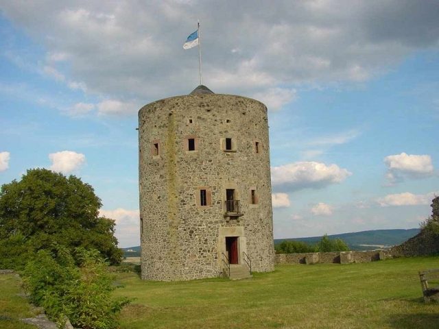
The Hohenburg, also called Homberg, is the ruin of a hilltop castle in Homberg (Efze) in the Schwalm-Eder district in North Hesse.
The Hohenburg ruin is located in the core town of Homberg on the wooded Schloßberg (376.5 m above sea level), a basalt cone rising steeply from the Efze floodplains south of the mountain, surrounded to the west, south, and east by the built-up areas of the town.
Homberg was located at the intersection of two historic trade routes, the road from Fritzlar via Homberg to Hersfeld and the Lange Hessen. This gave the location important strategic significance.
By whom and when the castle was built is not known. However, in 1162, a Rentwich von Hohenburg was first mentioned in a document; this family died out in 1427 with Simon vom Hohen Berg. From about 1190, it was in the possession of the Landgraviate of Thuringia. The castle was first mentioned in a document in 1246. Together with the town, the castle formed a unit. It was of great importance for the old trade route Frankfurt-Leipzig.
In the 13th century, under Landgrave Heinrich I, it became part of the newly formed Landgraviate of Hesse. It became the administrative center of the Homburg office. In 1508, the brother of the Hessian Landgrave Ludwig II of Lower Hesse, Archbishop Hermann IV of Cologne, was the owner of the castle and had it extensively rebuilt. A bronze plaque, found during excavations at the castle, bears the inscription: Herman von Gotzes gnaden Erzbyschoff zu Colne, des heiligen romschyn richs durch Ytalien, Ertzcantzler, Kurfürst, Herzog zu Westvaln und Engern, des Stifts zu Paderborn, Administrator A(nno) 1508. The bronze plaque is located in the local museum of Homberg. It is characterized by remarkable chasing work and is adorned with the archiepiscopal and landgravial coats of arms.
From 1605 to 1613, Landgrave Moritz had the re-excavated castle well, which with a depth of 150 meters is one of the deepest wells in Germany, constructed for 25,000 Thalers and the castle further reinforced.
The Landgraves of Hesse-Kassel initially maintained neutrality in the Thirty Years' War until 1631. From 1634, the war was brought into Hesse. On July 16, 1636, the town of Homberg was occupied by imperial troops. However, the siege of the castle by General Johann von Götzen with an imperial army of 13,000 men was successfully repelled. During a renewed siege on August 3, 1636, the castle garrison had to surrender due to a lack of water supply. The citizens of the town could not meet the contribution demands of Colonel Tirell. Thereupon, he had the town and castle burned down.
Generalwachtmeister Rabenhaupt besieged the castle from January 28 to 30, 1648, and was able to recapture it for the Landgraviate of Hesse-Kassel. On February 9, 1648, there was another capitulation.
The heavily damaged castle fell into disrepair and was partly used as a quarry for the reconstruction of the equally heavily damaged town of Homberg. Many structural components of the former castle can still be found in the townscape today.
Current Use+
In 1822, the ruin came into the possession of the town of Homberg. Since 1936, it has been excavated, restored, and maintained by a castle association. From 1952 to 1958, a keep was erected on old foundations. This was not built according to historical models. The castle well was excavated from 1997 to 2001.
Today, a restaurant is located on the grounds of the outer bailey. a castle tower serves as an observation tower, from which views of Homberg and its surroundings can be enjoyed.
Layout+
The formerly very extensive castle complex featured a small outer bailey (zwinger) with an outer castle gate, a drawbridge over the moat, and outer bastions, connected via a gate tower with a battlement to the main castle and an entrance to the castle chapel. Furthermore, the castle had a round keep, a palas with a knight's hall, a well house with a 150 m deep castle well (third deepest castle well in Germany), a stable, military quarters, a gun house, an arsenal, a shooter's oriel, a commander's house, and a stair tower. The curtain wall had a wall thickness of 1.5 meters.
The massive castle tower, 11 m in diameter and 14 m high, is not part of the historical structure but was built as an observation tower in the style of old keeps by the Burgberggemeinde from 1952 to 1958.
Take Mobile History with you
You are reading this text for free. Premium adds what matters on the road: descriptions read aloud, sites found through your camera, whole regions taken offline.
- Every description, including the ~17,700 Premium sites
- Audio guide: have descriptions read to you on location
- AR finder: see sites through your camera, with distance and bearing
- Unlimited saved sites
14 days free, then from €2.99 a month. Cancel anytime.
Source: Wikipedia · Licence: CC BY-SA 4.0 · Image: Roland Neubert, Halle (Saale)
This description draws on the facts documented in the linked Wikipedia article; Wikipedia content is licensed under CC BY-SA 4.0. Wording and editing: Mobile History.
Location: 51.0366, 9.4062