The remains of the castle can be visited
CastleGütighofen
Hauenfels Castle
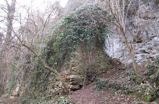
Hauenfels Castle was a cave castle near the Teufelsküche (Devil's Kitchen) on the Ölberg (Mount of Olives) near Gütighofen, close to Ehrenkirchen in the Breisgau-Hochschwarzwald district (Baden-Württemberg).
Its history is largely unexplored. It is disputed whether the solid structure on the Ölberg is even a castle complex. The name Hauenfels also stems from an erroneous interpretation of the mention "Huwensteine", which should correctly be translated as Owl Stone. A possible first mention as the aforementioned Huwensteine, in a court roll of the Ding- and Fronhof in Bollschweil, owned by St. Ulrich's Monastery, is dated to the year 1316. Finds from the building site indicate a period of use from the 13th to the early 16th century. In the late 1990s, parts of the masonry, such as an upper section of the front wall with a loophole-like opening, fell victim to vandalism.
During the Thirty Years' War, the building served as a hiding place for Dominican Father Michael of the Preacher's Monastery in Freiburg. From there, together with scattered Austrian soldiers and farmers, he waged a successful guerrilla war against the Swedes in nearby Kirchhofen. Later, the building served as a hideout for robber gangs.
Layout+
Of the structure, built into a slight rock overhang, a roughly 13 m long and up to 1.2 m thick section of the wall of the southeastern long facade, made of mortar-jointed roughly hewn limestone rubble in irregularly layered courses, as well as a 0.75 m thick remnant of the northeast side with a clear width of 3.1 m, are preserved. At its eastern corner, the outer wall still reaches an estimated height of 4 m. A beam hole in the front wall suggests at least a two-story extension. Remains of a 0.6 m thick inner wall indicate a division into two approximately rectangular rooms. Two loophole-like openings, still visibly outlined in the masonry of the front wall, provided light. A plan sketch by Zuccamaglio from the 1860s, showing building details no longer visible today, offers an impression of the structure.
Take Mobile History with you
You are reading this text for free. Premium adds what matters on the road: descriptions read aloud, sites found through your camera, whole regions taken offline.
- Every description, including the ~17,700 Premium sites
- Audio guide: have descriptions read to you on location
- AR finder: see sites through your camera, with distance and bearing
- Unlimited saved sites
14 days free, then from €2.99 a month. Cancel anytime.
Source: Wikipedia · Licence: CC BY-SA 4.0 · Image: http://commons.wikimedia.org/wiki/File:Bau_am_%C3%96lberg_%28Burg_Hauenfels%29_01.JPG
This description draws on the facts documented in the linked Wikipedia article; Wikipedia content is licensed under CC BY-SA 4.0. Wording and editing: Mobile History.
Location: 47.9186, 7.7676