The remains of the Castle can be visited
CastleHartenfels
Hartenfels Castle
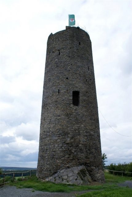
Hartenfels Castle is the ruin of a hilltop castle and one of the most striking castle complexes in the Westerwald.
The castle is located on a 368 m above sea level basalt cone above the small municipality of Hartenfels, which belongs to the Verbandsgemeinde Selters (Westerwald) and is located in the Westerwaldkreis in Rhineland-Palatinate. The village and castle are about 80 kilometers as the crow flies northwest of Frankfurt am Main and 70 kilometers southeast of the city of Cologne.
The complex was located on the Hohe Straße, which in the Middle Ages was an important trade route connecting both cities.
The castle was first mentioned in a document from 1249, when it was sold by its then owner, Countess Mechthild von Sayn, to the Archbishop of Trier. The castle complex served to protect the Hohe Straße, the most important trade route between Frankfurt am Main and Cologne. This road is now the B8.
After the castle was destroyed in the 15th century and rebuilt, the complex was finally destroyed in 1594 by Count Wilhelm von Nassau. No further reconstruction has taken place.
A legend says that a secret tunnel leads from Hartenfels Castle to the 4 km distant Arx Hergispach (today Marienheim Monastery) in Herschbach. An entrance can still be found in the monastery today.
Description+
In a record by Wilhelm Lotz from 1873, Hartenfels Castle is described as follows:
„On a high basalt cone, the round keep still rises to a height of 18 m with a diameter of 9 m, built of shaly basalt rubble stone. Above the dungeon, whose dome vault has collapsed, there are three floors. In the first, the segmental arched entrance with an inner round arched blind arch, opposite it a wide, deep, also round arched blind arch. In the 2.35 m thick tower walls here are the stairs, which open inwards into round arched or at the top with three sides of an octagon covered doors. Narrow rectangular loopholes. No projection on the outside. The battlements destroyed. The tower stands freely in the bailey, initially on the south side. Almost nothing remains of the polygonal and semi-circular inwardly open towers of the castle's curtain walls.“
Naming+
The ruin is popularly known as "Harbelser Schmanddeppen". It is said that a French soldier once asked a woman for the name of the tower. But she confused this with a butter churn, which is called Schmanddeppen in the dialect. A simpler explanation is also possible, that the shape of the castle led to the name.
The Castle Today+
The keep, still towering a good 23 meters high, and originally probably over 28 meters high, dominates the village and the appearance of the castle complex.
In addition to the keep, which cannot be climbed, there are further remains of walls (mainly the curtain walls) in the approximately 60 x 40 meter castle ruin, which is freely accessible.
Take Mobile History with you
You are reading this text for free. Premium adds what matters on the road: descriptions read aloud, sites found through your camera, whole regions taken offline.
- Every description, including the ~17,700 Premium sites
- Audio guide: have descriptions read to you on location
- AR finder: see sites through your camera, with distance and bearing
- Unlimited saved sites
14 days free, then from €2.99 a month. Cancel anytime.
Source: Wikipedia · Licence: CC BY-SA 4.0 · Image: Roland Neubert, Halle (Saale)
This description draws on the facts documented in the linked Wikipedia article; Wikipedia content is licensed under CC BY-SA 4.0. Wording and editing: Mobile History.
Location: 50.5711, 7.7822