The remains of the castle can be visited
CastleMeiningen
Habichtsburg Castle
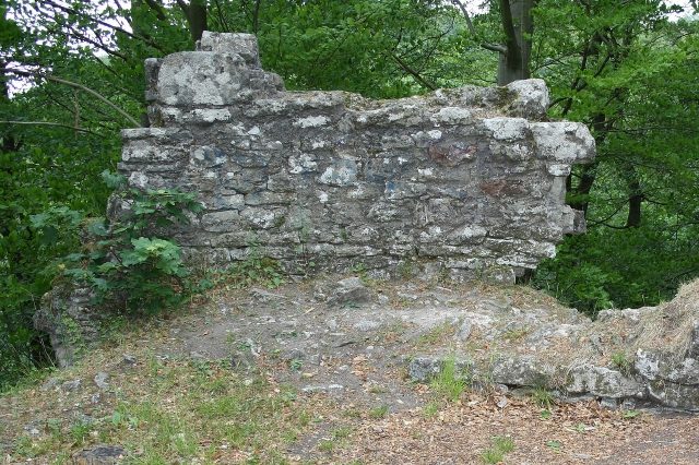
The Habichtsburg, formerly called Habesburg, was a medieval rock castle on a rocky spur about 40 meters above the valley floor of the Haßfurter Grund. Together with the city of Meiningen and the northern neighboring town of Walldorf (Werra), it formed an exclave of the Prince-Bishopric of Würzburg between 1008 and 1542 and already possessed great strategic importance at the time of its construction. The castle is located on the eastern edge of the Rhön in the northwestern part of the Meiningen city forest on the western slope of the Kallberg (415.8 m above sea level). About two kilometers north was the Würzburg castle Landeswehre, which is now built over by Landsberg Castle. The distance to Meiningen city center is about 2.5 kilometers as the crow flies. From the western city limits, Landsberg and the district of Dreißigacker, the Habichtsburg is easily accessible via signposted hiking trails. The castle is located slightly below the mountain ridge on a rocky outcrop.
Description+
The castle complex, only about 70 x 40 meters in size, is situated on a rocky spur. On three sides, vertically dropping rock faces provided natural protection. From the eastern direction, access was gained through a neck ditch up to seven meters wide and ten meters deep, as well as a barrier ditch, now only recognizable in remnants, located about thirty meters in front of it. A precise interpretation of the existing wall remains and their dating is complicated by the fact that the site was built over with an artificial ruin in the 19th century, but whose building material was largely taken from the medieval castle ruin.
Behind the neck ditch, the rising remains of the eastern part of the curtain wall can initially be found. The building located here had to be particularly protected in the event of an attack, which is why the former keep stood directly next to the building. This was a round tower (5.2 meters inner diameter) built of two-shell masonry. It was replaced by a pavilion in the 19th century. The western buildings and courtyards are located in a rocky area accessed by stairs on three terrace levels. There is still greater uncertainty about the size and appearance of the buildings, as hardly any wall remains are recognizable. On the northern steep slope, a staircase leads to a circular shaft of 3.1 meters in diameter, dug into the rock. The shaft was excavated to the bottom in the 19th century, probably in the usual hope of valuable finds, thus destroying the scientific findings. Today, the hiking trail passes by, allowing visitors to take a tour of the castle grounds.
In 1008, as part of his domestic politically motivated imperial church policy through the new foundation of the Diocese of Bamberg in 1007, Henry II made large donations from imperial property to the monasteries and their abbots, as well as the dioceses and bishops of the empire. Thus, the royal estates of Meiningen and Walldorf also came to the Diocese of Würzburg. To protect this exclave, among other things, the Habichtsburg was built. At the same time, the castle allowed complete surveillance and control of the trade routes leading from Gotha to Würzburg, Fulda, and Frankfurt am Main, the so-called Hohe Straße, also known in Haßfurt as the Alte Frankfurter Straße. In the 12th century, Count Goswin von Stahleck acquired the castle from the Bishop of Würzburg. His son, Count Palatine of the Rhine Hermann von Stahleck, sold it in 1256 to finance the Bildhausen monastery. With the relocation of trade routes, the Habichtsburg lost its strategic key position and fell into disrepair. A later reconstruction was not permitted by the Würzburgers.
Take Mobile History with you
You are reading this text for free. Premium adds what matters on the road: descriptions read aloud, sites found through your camera, whole regions taken offline.
- Every description, including the ~17,700 Premium sites
- Audio guide: have descriptions read to you on location
- AR finder: see sites through your camera, with distance and bearing
- Unlimited saved sites
14 days free, then from €2.99 a month. Cancel anytime.
Source: Wikipedia · Licence: CC BY-SA 4.0 · Image: http://de.wikipedia.org/w/index.php?title=Datei:Habichtsburg-004.JPG&filetimestamp=20110720094242&
This description draws on the facts documented in the linked Wikipedia article; Wikipedia content is licensed under CC BY-SA 4.0. Wording and editing: Mobile History.
Location: 50.5866, 10.3924