The remains of the Castle can be visited
CastleFreudenberg
Freudenberg Castle
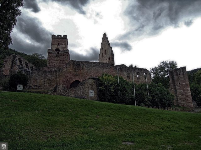
Freudenberg Castle, also known as Freudenburg, is the ruin of a hilltop castle near Freudenberg in the Main-Tauber district (Baden-Württemberg).
The ruin is located at 252.1 m above sea level on the lower slope of a wooded mountainside between two short, parallel, northwest-running stream incisions leading to the Main, which flows about 120 m lower in a curve to the southeast, above the town of Freudenberg in the valley.
In 1197, Bishop Heinrich III of Berg had a residential tower built. Under the Würzburg Bishop Konrad I of Querfurt, there was another construction phase, but on a smaller scale. The Counts of Wertheim were probably the feudal lords of the castle from the beginning. However, they are only definitively traceable from 1295 with the enfeoffment of "castrum et oppidum" Freudenberg by Kunigunde of Wertheim.
In 1361, among other things, the curtain wall and the palas were further built by Eberhard of Wertheim.
A further expansion and enlargement of the castle into a fortified fortress with an imposing Renaissance building took place between 1497 and 1507 by Count Erasmus of Wertheim. A bailey was erected through massive embankments. The imposing four-story cannon tower on the Main side and an outwork to secure the southern mountainside were built. Another protective wall with three small round towers was placed in front of the zwinger wall. The wall extended to the southwest gate, which was additionally secured by an enclosed interior and a tower. Only after passing through a second and third gate was access to the core castle possible. This was enclosed in an approximately triangular layout. In the southwest corner is the palas, in the northeast corner another stone building of approximately the same size, and in the southeast the famous three-story oversized keep. Another small third stone building leaned south against the battlement. The last built outer defensive wall was extended west and east down the mountainside to the Main and enclosed the castle town of Freudenberg. This castle expansion, probably based on Breuberg Castle, was Erasmus (also Asmus) of Wertheim's last life's work. He died in 1509.
The castle was only used as a castellan's and administrative seat. In 1552, it was severely damaged in the Margrave War, and with the extinction of the Wertheim family in 1556, the castle began to progressively decay. The administration was moved to the town, and only the cannon tower (especially during the witch trials after 1590) continued to be used as a prison.
With the end of the Middle Ages, the castle fell into disrepair and became overgrown with bushes and trees. It was forgotten for centuries. Only after the Second World War did a citizens' initiative advocate for the castle. It was gradually uncovered and renovated and reopened to the public in a renewed state in 1995. Currently (as of 2012), the curtain walls towards the town and the cannon tower are being renovated.
Layout+
The layout of Freudenberg Castle features a unique three-tiered keep with an edge length of 14.65 by 14.65 meters. Built before 1197 as a symbol of the power of the Würzburg bishops on the Main, it was intended as a southern bulwark against the expansionist ambitions of the Lords of Dürn and the Mainz bishops. After the death of Heinrich III (Ruprecht I of Dürn had also died and his son no longer sought to expand the Dürn territory), the tower was continued in further stories with a reduced diameter. The second construction phase, whose clamp holes point to a time after 1220, is to be seen as contemporary with the construction of Mainz Castle Miltenberg and Wildenberg Castle of the Dürn family. The lower part is about 12 meters high and built of ashlar blocks. The second floor, also built with ashlar blocks, suggests by the same stonemason's marks that the middle part was continued with the parts still at the construction site. This part is fortified with a battlement with merlons and four tourelles. The keep only received its completion with a battlement and fighting platform at the end of the 14th century by Count Eberhard of Wertheim. The keep has a height of about 32 meters.
Current Use+
The castle courtyard of the ruin now serves as an open-air stage every two years in odd-numbered years.
Miscellaneous+
A circular path above the castle leads (west to the turning point) past a pile of stones called "Raubschlösschen" (Robber's Castle), where only parts of a wall can still be seen on the steep mountainside sloping down to the Main.
Take Mobile History with you
You are reading this text for free. Premium adds what matters on the road: descriptions read aloud, sites found through your camera, whole regions taken offline.
- Every description, including the ~17,700 Premium sites
- Audio guide: have descriptions read to you on location
- AR finder: see sites through your camera, with distance and bearing
- Unlimited saved sites
14 days free, then from €2.99 a month. Cancel anytime.
Source: Wikipedia · Licence: CC BY-SA 4.0 · Image: Mobile Geschichte
This description draws on the facts documented in the linked Wikipedia article; Wikipedia content is licensed under CC BY-SA 4.0. Wording and editing: Mobile History.
Location: 49.7390, 9.3234