The remains of the castle can be visited
CastleSchmalkalden-Helmers
Frankenberg Castle
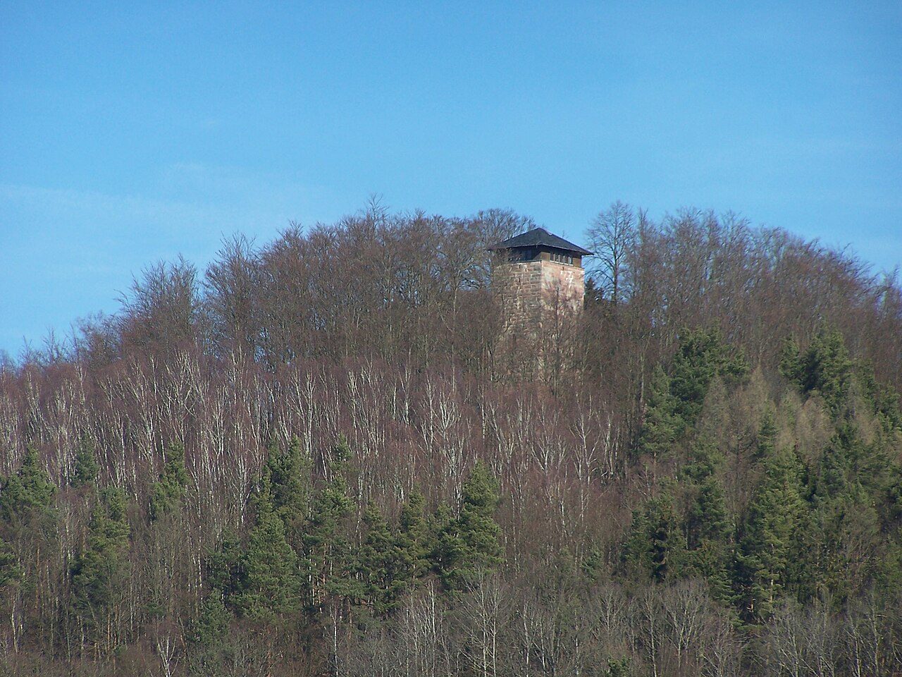
Frankenberg Castle was a medieval fortification built on the Schlossberg near Helmers in the Schmalkalden-Meiningen district in Thuringia.
The structural remains of the spur castle at 350 m above sea level are located 500 m north of the village of Helmers in the lower Rosagrund. The castle, with an outwork located in the village of Helmers, was built at a time when it was situated on an important ancient road that led to the Werra crossing with the double monastery of Breitungen and passed closely to the west of Frankenberg Castle. In the 15th century, an extensive landwehr (defensive line) was built near the castle to protect the Henneberg administrative border, running between the towns of Breitungen and Roßdorf. The castle ruin of Todenwarth, located on the northern bank of the Werra, has been the starting point for another Henneberg landwehr since the 14th century, which runs towards the Thuringian Forest, parallel to the Schmalkalde valley.
The construction of the castle, of which remains are preserved today, is dated to the period around the late 11th to early 12th century. The first documented mention dates from 1137. At that time, the castle was owned by the Lords of Frankenstein, who were first mentioned in the same year. Whether the castle was built by the Frankensteins, or how it came into their possession, is not known. The castle served as a fortress to protect the trade route running through the Rosatal from Frankfurt am Main via Dermbach and Schmalkalden to Erfurt.
The first reliable records of the Frankenberg branch of the Frankenstein family were documented in 1180 with Otto, who also called himself Otto von Stein (de lapide). He and his descendants named themselves after the Frankenberg. The dominion occupied by the Frankenbergs was of small size and bordered in the southwest on the dominion of the Counts of Neidhardtshausen, in the west and north on the territory of the Frankensteins, and in the east and south on the territory of the Counts of Henneberg. The importance of this small dominion grew with the transfer of the protective vogtei (advocacy) over the Premonstratensian monastery in Frauenbreitungen. The family of the castle lords of Frankenberg subsequently owned, in addition to their ancestral property in the Rosatal, scattered possessions in the Stillergrund near Schmalkalden, Altenbreitungen, Breitenbach, Untergrumbach, and Fischbach.
As a result of the Thuringian War of Succession, the military and political power relations in the region had shifted significantly. In 1278, the heirs of the knights Heinrich and Otto von Frankenberg requested the enfeoffment by Hersfeld Abbey. By 1293, the lineage had died out in the male line. Therefore, the Counts of Henneberg-Schleusingen, with the consent of the Hersfeld abbots, received Frankenberg Castle from the Thuringian Landgrave Albrecht. In 1301, the vogtei rights in Frauenbreitungen were also transferred to the Henneberg counts. The neighboring dominion of the Frankensteins was simultaneously shaken by a military campaign of King Adolf of Nassau and fell into deep debt. The Counts of Henneberg were thus able to expand their dominion by a significant part on the northern edge of the Rhön and in the middle Werra valley. Count Berthold VII of Henneberg initiated the formation of the Frankenberg Amt (administrative district) with the addition of the village of Wernshausen.
Around 1360, the Frankenberg Amt was designated as a pledged possession. The pledge holders changed rapidly, while the Henneberg counts retained feudal sovereignty over Frankenberg Castle, even after the Henneberg division of 1347, when the territory passed to Count Johann von Henneberg. The last noble resident was Heinz von der Tann, who died in 1521 at the castle, which was already in structural decay. The servants and officials housed in the castle had already left the castle before 1525, so the armed peasants in the spring of 1525 had no resistance to fear when a group of peasants set fire to the former fortress. In the following centuries, storms caused further damage, and usable stones were carried away by the peasants. The administrative seat associated with the castle was moved to Frauenbreitungen after the secularization of the monasteries, whereby the Amt has since been called "Amt Frauenbreitungen".
Until the 19th century, the keep and parts of the palas remained of the castle. The castle ruin, now recognized as a cultural monument, was made accessible again around the turn of the century and advertised by hiking guides as an attractive excursion destination. During the GDR era, the castle had almost fallen into oblivion. Only in 1983 did a group of local heritage protectors in the community of Helmers begin to care for the ruin again, founding the "Interessengemeinschaft Burg Frankenberg" (Frankenberg Castle Interest Group). In 1988, a reconnaissance excavation was carried out on the castle grounds to investigate the location and extent of the former buildings in the castle courtyard. The walls, which were in danger of collapsing, were secured, and a log cabin was built near the castle ruin. Subsequently, a staircase could also be installed in the tower.
Layout+
The castle complex was built on the southern spur of the Schlossberg and was cut off from the mountain by a deep neck ditch. The castle, built on a steep slope, had a triple ring wall. In the core castle, the still existing keep overlooked a castle courtyard densely covered with buildings. This has a square floor plan with a side length of 7.35 m and consists in the lower part of large-format reddish sandstone bossed ashlar blocks with clamp holes; the original high entrance is located on the southwest side at a height of 11 m.
The approximately 11 m long palas leans against the northeast side of the tower. The palas and other outbuildings formed the core area of the castle, which was probably accessible via a gate tower. East below the keep was a leveled area that had housed the economic wing of the castle; this area was also protected by the middle ring wall. The outer ring wall surrounded the core castle and a surrounding ditch.
Current Situation and Use+
The castle complex is designated as an archaeological monument and, with its 24 m high observation tower, has regional tourist significance. A castle festival has been held at the castle ruin on Whit Sunday since the 1990s.
Miracle Story+
The husband of Saint Elisabeth of Thuringia, Landgrave Ludwig, was revered even after his death. The miracles and legends collected in this context were intended to support his canonization. In the chronicles of Wigand Gerstenberg of Frankenberg (1457–1522), an extensive list of such miracle stories attributed to the Landgrave is reported. For example, on August 12, 1293, the following miracle is said to have occurred at Frankenberg Castle near Helmers:
- “A simple farmer from Schwallungen had found a treasure while working in the fields. The landlord got into a dispute with the farmer about it and demanded the surrender of the treasure. The judge sentenced the farmer to imprisonment. The farmer disappeared into a barred room behind lock and key at Frankenberg Castle. He felt innocent and, in his despair, called upon Landgrave Ludwig as a helper in need. He prayed and made a vow before God. Then a miracle happened: the prison door opened, and with God's help, the farmer also found his way out of the castle unmolested; he was free again. In gratitude, he fulfilled all his obligations, visited Ludwig's grave, praised and revered the deceased Landgrave all his life for his liberation.”
Take Mobile History with you
You are reading this text for free. Premium adds what matters on the road: descriptions read aloud, sites found through your camera, whole regions taken offline.
- Every description, including the ~17,700 Premium sites
- Audio guide: have descriptions read to you on location
- AR finder: see sites through your camera, with distance and bearing
- Unlimited saved sites
14 days free, then from €2.99 a month. Cancel anytime.
Source: Wikipedia · Licence: CC BY-SA 4.0 · Image: Metilsteiner / CC BY 3.0 via Wikimedia Commons
This description draws on the facts documented in the linked Wikipedia article; Wikipedia content is licensed under CC BY-SA 4.0. Wording and editing: Mobile History.
Location: 50.7295, 10.2954