The remains of the Castle can be visited
CastleWodarg
Conerow Castle
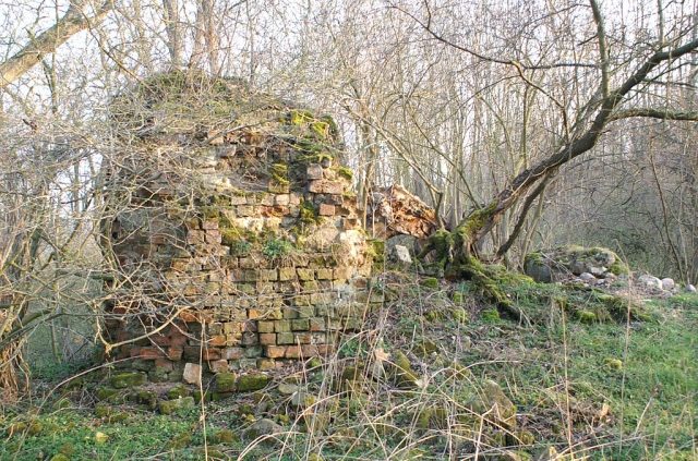
The name Conerow refers to an early German castle from the early 13th century in today's Mecklenburg-Vorpommern in the Mecklenburg Lake District. The castle complex is difficult to access as it is located in the middle of the Wodarger Forstwald, and no direct path leads to it.
Conerow Castle+
The ruins of Conerow Castle are located about 2.4 km west of the village of Wodarg directly on a loop of the Tollense river. The first documented mention of the complex was in 1248. Today, only remnants of walls on a 5 to 6 meter high castle mound, 30 to 40 meters in diameter, are visible. The ruin, located on the north side of the mound, is the remainder of the square keep with a wall thickness of 2 meters. Of the masonry, still 4.50 meters high on the west side, the upper 3 meters consist of so-called monastery bricks. The foundation, like the interior of the masonry, was built from fieldstones. Little is known about the builders and original owners. They belonged to the von Walsleben family. The first records date from 1473 (Walslenen) and 1486 (Walslaw). In 1642, Alexander von Walsleben acquired the Wodarg estate.
About 200 meters upstream on the west bank of the Tollense, an amateur archaeologist from Burow found the first traces of a Bronze Age battlefield in 1996, which has been investigated since 2007 and excavated since 2010. Previous exploratory excavations have unearthed bones of more than 100 deceased.
Whether the accumulation of erratics located on the west bank of the Tollense almost opposite the castle indicates an early settlement in the Megalithic period has not yet been explored. About 500 meters south in the Wodarger Forest, east of the Tollense, there are two megalithic tombs.
Conerow Village+
West of the village of Wodarg was a smaller settlement belonging to the castle, known by the name Conerow. Today, the Bundesautobahn 20 runs over this village, which fell into disuse in the 14th century. The cause of the decline of the place was the devastation during armed conflicts between Mecklenburg and Pomeranian princes. The inhabitants probably settled in the village of Kölln (Colon, Cölln), located about one kilometer northeast, which was also necessitated by the change from livestock farming to arable farming during this period.
In the run-up to the motorway construction, the remains of a fortified granary in half-timbered construction were found west of Wodarg. A replica of it is located near Klempenow Castle.
Take Mobile History with you
You are reading this text for free. Premium adds what matters on the road: descriptions read aloud, sites found through your camera, whole regions taken offline.
- Every description, including the ~17,700 Premium sites
- Audio guide: have descriptions read to you on location
- AR finder: see sites through your camera, with distance and bearing
- Unlimited saved sites
14 days free, then from €2.99 a month. Cancel anytime.
Source: Wikipedia · Licence: CC BY-SA 4.0 · Image: http://commons.wikimedia.org/wiki/File:Burg_Conerow_02.jpg
This description draws on the facts documented in the linked Wikipedia article; Wikipedia content is licensed under CC BY-SA 4.0. Wording and editing: Mobile History.
Location: 53.7516, 13.3096