Museum
CastleDornburg-Camburg
Camburg Castle
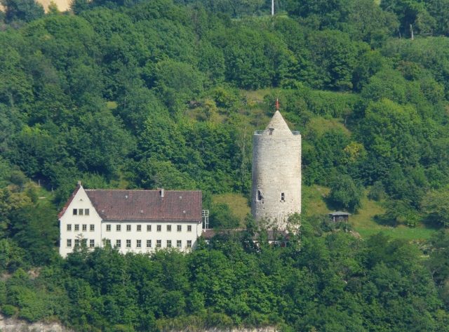
Camburg Castle is the ruin of a hilltop castle in the small town of Camburg on the Saale in the Saale-Holzland district in Thuringia, about 20 km north of Jena, halfway to Naumburg.
The castle hill (179 m above sea level), located on the right bank of the Saale on the "Meissen town side" of Camburg, extending in a north-south direction, approx. 285 m long and 25-75 m wide, is divided into two parts by a wide and deep neck ditch, through which the federal highway B 88 now runs. Originally, the north-south connection, called the Saale Valley or Nuremberg Road, which has been preserved as an impressive sunken road, ran along the eastern slope through the valley of the Schleuskau stream. According to medieval written sources, two castles are said to have existed in Camburg, a lower one (inferius castrum) and an upper one (superius castrum in Camburg, que vulgariter dicuntur Gehege). However, it can be assumed that both mentions refer to this complex and thus only distinguished the parts of the mountain spur lying at different heights.
Already in the second half of the 11th century, a collateral line of the Wettins took up residence in Camburg, after they had already gained a foothold upstream from their ancestral castle near Weissenfels. After 1088, a Wilhelm appears as Count of Camburg in a document. He was the middle son of Count Gero of Brehna (* around 1020; † after 1089) and brother of Günther I of Wettin († 1090, reg. 1079–1090), who was elevated to Bishop of Naumburg in 1079 by anti-king Rudolf of Rheinfelden (reg. 1077–1080). Together with his elder brother Count Dietrich of Brehna († before 1116), he is depicted among the founder figures created around 1250 in the west choir of Naumburg Cathedral. With Wilhelm, the line died out in the male line before 1116, and the County of Camburg fell to the Wettin Margrave of Meissen, Conrad the Great (1123–1156).
For the margraves, the castle was of great importance as a stronghold against the Ludowingians. Its traffic location was extraordinarily favorable, as it lay at an important Saale crossing and (later?) the intersection of the Saale Valley or Nuremberg Road with the so-called Salt Road, which led from Sulza on the Ilm via Schmiedehausen. The Wettins had the castle administered by ministeriales belonging to the family of a Gerhard von Camburg. From 1133 to 1190, representatives of a noble free family, who also named themselves after Camburg, also appear - mostly in Naumburg episcopal documents.
According to recent research by Wolfgang Hartmann, both families are descendants of Count Dietmar von Selbold-Gelnhausen from the Franconian noble family of the Reginbodones, whose wife Adelheid was closely related to Count Wilhelm von Camburg or his wife Gepa. According to Hartmann, the burgraves of Kirchberg, the noble free lords of Gleißberg (Kunitzburg) and other noble families in the area also descend from Dietmar and Adelheid. Within the already mentioned Naumburg founder cycle, the portrait of Wilhelm von Camburg is strikingly aligned with the statue of a (slain) Count Dietmar, who, according to Hartmann, is Wilhelm's relative (probably brother-in-law). Hartmann also connects the Camburg Cyriacus Chapel (as Adelheid's burial place) with Dietmar and raises the question of whether the division of Camburg Castle into two parts originated in a co-ownership of Counts Wilhelm and Dietmar. This could be supported by the fact that the Wettin heirs of Wilhelm von Camburg also played a role in the history of Gelnhausen Castle (as the predecessor of the imperial palace there).
Since Camburg was apparently intended to have a central function for the southwestern part of their dominion, the Wettins endeavored to expand the castle settlement, which already existed there on the right bank of the Saale in 1149. The castle is first documented in 1166 in a charter of Margrave Otto the Rich (1156–1190). In 1170, a chaplain of Camburg appears as a witness in a charter of Margrave Otto. The castle chapel itself is mentioned for the first time in 1213 and repeatedly thereafter. At the end of the 12th century, Camburg, along with Leipzig and Meissen, was one of the most important fortifications of Margrave Albrecht I the Proud (reg. 1190–1195). In the course of the dispute between him and his younger brother Dietrich, the castle was besieged and captured in 1191 by the Thuringian Landgrave Hermann I, who was allied with Dietrich. In 1194/95, Albrecht apparently had the castle rebuilt again.
In 1280, Camburg is said to have been unsuccessfully besieged by Count Günther von Kevernburg during the struggles of Albrecht II the Degenerate (1240–1314) with his sons. It is also sometimes assumed that Camburg was among the approximately 60 castles destroyed in 1290/91 by King Rudolf of Habsburg and the city of Erfurt. After frequent changes of ownership in the 14th century, the castle was sold to the Vitzthums in 1439 and completely destroyed except for the keep in the Saxon Fratricidal War in 1450 by Elector Frederick II the Gentle (1412–1464).
Even in the following period, the town of Camburg and the site of the castle frequently changed hands: in 1485 they first came to the Albertine line, in 1573 to the Ernestine line of the Wettins, in 1603 to the Duchy of Saxe-Altenburg, which emerged from this line, and subsequently to other of the frequently changing Ernestine duchies. At the end of the 19th century or the beginning of the 20th century, a restaurant was built in the castle ruins and the area was transformed into a park. The restaurant was demolished in January and February 1935, and the lower castle was converted into a "youth castle" for the Hitler Youth and the League of German Girls.
After extensive renovation, the keep has been used as a museum since 2005.
Layout+
Of the complex, probably founded in the second half of the 11th century and destroyed in 1450, only the impressive keep and a few remains of the curtain wall have survived.
Preserved structural remains
The lower castle, in the area now called Turmberg, is an approximately square complex. The 37 m high keep with an outer diameter of 11 m, which probably originated in the second half of the 12th century or at the beginning of the 13th century, has been preserved. Some remains of the arched castle wall still extend from it. Of the presumed upper castle, now called Matzberg, the massive 45 m long, 25 m wide and 15 m high earthen rampart, which seals off the spur to the south, has been preserved. There is a considerable difference in height between the two.
Results of the archaeological investigations in 1935
During the excavation of a building pit for the "Jugendburg" in January and February 1935, several wall sections and finds were uncovered along the western edge of the mountain. At the site of today's L-shaped residential wing, a slightly trapezoidal cellar (5 x 6 m) and other foundation remains were uncovered and subsequently measured by Prof. Dr. Gotthard Neumann and the staff of the Germanic Museum of the University of Jena. Although this was not a regular scientific excavation, as the uncovering and recovery of finds were in the hands of the architect and the construction manager, the investigation of the Camburg ruin is nevertheless one of the first medieval archaeological measures on a castle in Central Germany.
The uncovered walls belong to a larger and probably representative building that rose south of the keep. Since the rooms showed traces of fire and were filled with building and fire debris containing a large number of finds, it can be assumed that this building was destroyed by fire.
The oldest finds date from between 1080 and 1220/25. Fragments of older pottery in Slavic manufacturing tradition are not yet available from either the Turmberg or the Matzberg. The bulk of the ceramic material belongs to the gray/blue-gray earthenware of the 13th to 15th centuries. In addition to earthenware, stoneware is also represented with several examples, including a so-called Jacobakanne, which probably comes from Waldenburg production. The stoneware vessels mostly date to the 14th century. A few pieces, such as a small handled pot and the remains of a mineral water bottle made of stoneware, are from modern times.
Among the extraordinary ceramic finds are the remains of an aquamanile in the form of a horse's head and the torso of a rider, as well as a mask, which is probably intended to represent a lion's head. The remains of a ribbed glass beaker date to the middle of the 15th century. Among the coin finds, a Prague groschen and the lid of a box for Meissen groschen are particularly noteworthy. Other finds include copper fittings with inscriptions, strap fittings made of copper or brass, an earring originally probably set with a pearl, a beaded wire with gilding, and an eight-tined bone comb. A number of weapon parts and metal tools were also recovered, such as a bolt tip, the nut of a brass crossbow, remains of two trapezoidal stirrups (m), several wave and slipper irons, a donkey iron, chain parts, a door hinge, numerous fittings, a manure fork and a meat fork, among others. The fragment of a spur can only be generally dated to the 10th/11th century. A poultry bone with a central drill hole may have served as a toggle or as a buzzer/whirler, a toy that produces a sound by means of a twisted thread. However, the significance of the finds remains limited due to the lack of a more precise stratigraphic classification.
Overall, this confirms the construction of the castle no earlier than the second half of the 11th century, as already indicated by written sources. An assumption, made since the 19th century and occasionally still asserted today, that the complex dates back to the 9th/10th and early 11th centuries, can be almost ruled out. A more precise archaeological dating of the beginnings is still hardly possible; based on the finds, only the existence of a castle around 1200 or in the first quarter of the 13th century is certain. The complex met its end in the middle of the 15th century, whereby a connection between the described fire damage and the documented destruction in the Saxon Fratricidal War in 1450 can be assumed. However, the area was also occasionally visited and used for various purposes in the following period, as indicated by some younger finds.
No archaeological investigations have been carried out on the upper castle so far. During the redesign of the area into a park at the beginning of the 20th century, a few finds were recovered. These include another steep comb, which can also only be generally dated to the 12th-14th century, a spearhead, and six crossbow bolt tips. The finds are lost and only preserved as drawings. A determination of the age of the complex and a comparison with the lower castle are therefore not possible. It is also unclear whether the massive section was built in the Middle Ages or belongs to a Bronze Age castle complex, as some Urnfield period ceramic fragments are available from the area of the lower castle.
Take Mobile History with you
You are reading this text for free. Premium adds what matters on the road: descriptions read aloud, sites found through your camera, whole regions taken offline.
- Every description, including the ~17,700 Premium sites
- Audio guide: have descriptions read to you on location
- AR finder: see sites through your camera, with distance and bearing
- Unlimited saved sites
14 days free, then from €2.99 a month. Cancel anytime.
Source: Wikipedia · Licence: CC BY-SA 4.0 · Image: Thomas Eichler
This description draws on the facts documented in the linked Wikipedia article; Wikipedia content is licensed under CC BY-SA 4.0. Wording and editing: Mobile History.
Location: 51.0525, 11.7114