The remains of the Castle can be visited
Museum
CastleBurgthann
Burgthann Castle
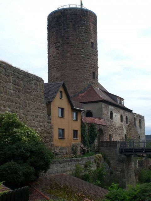
Burg Thann, also known as Burgthann, is the ruin of a spur castle on a 420 m above sea level high mountain spur above the Schwarzach valley in the municipality of Burgthann in the Middle Franconian district of Nürnberger Land in Bavaria.
The castle was built in the 12th century by the imperial ministeriales of Thann, whose ancestral seat was in Altenthann. In 1160, a knight of Thann on the Göckelsberg was mentioned for the first time.
In 1287, after the Thann family had presumably died out, the castle was first documented. Subsequent owners mentioned included Duke Ludwig of Bavaria, King Rudolf I, Burgrave Friedrich III of Nuremberg, and others. From 1346, the castle was the seat of a Hohenzollern administrative office (Pflegamt).
In 1381, the robber knight Eppelein von Gailingen, well-known in Franconia, was imprisoned in the castle for one night before being handed over to the executioner of Neumarkt.
In 1460, the castle was destroyed in the Bavarian War and rebuilt in 1463. During the Thirty Years' War, imperial troops destroyed the southeast wing of the castle in 1635. In 1648, it was plundered by Swedish troops and rebuilt after 1652. After the Pflegamt was relocated in 1792, the castle passed to various owners, fell into disrepair, and was used as a quarry.
Initial safeguarding measures began in 1968 and were continued on a large scale by the municipality of Burgthann in 1988.
Current Use+
The partially inhabited castle houses a small local history museum, which exhibits, among other things, finds from archaeological excavations from 1987 to 1989. During opening hours, the keep can be climbed. In summer, the castle festival of the Burg Burgthann Support Association and a jazz festival take place on the castle grounds. In 1995, the Bavarian Ludwig-Donau-Main-Kanal-Museum was opened at the castle, which is maintained by the Burg Burgthann Support Association. Precious unique pieces and originals from the Nuremberg, Ansbach, and Regensburg water management offices are exhibited there. In 2007, during a cleaning operation by the Research Group Caves and Karst Franconia e.V., the 14-meter-deep castle well was cleared of debris.
Since June 2010, it has been possible to get married civilly in the inner courtyard. The first mayor, Heinz Meyer, performed the first wedding.
Construction History and Layout+
The outer bailey, of which remnants of walls still bear witness, was separated from the hill by a neck ditch carved into the rock. The core castle (main castle) has a narrow outer bailey in front of it with a gatehouse destroyed by lightning in 1897, presumably formerly with a drawbridge. The archway dates from more recent times.
The curtain wall, largely built of sandstone ashlar with battlements, is almost completely preserved. The no longer preserved palas, of which light slits and a latrine bay still bear witness, was located on the west side. The outer wall, built of medium-sized ashlar from the 12th century, is the oldest part of the castle complex.
The well-preserved, 27-meter-high round keep made of bossed ashlar masonry with a square interior dates from the 13th century. The still well-preserved Pflegamt building from more recent times, above whose entrance a dragon relief can be seen, is located on the south side.
The half-timbered castle chapel was later added to the outside of the curtain wall. On the east side are the remains of a large building destroyed in the Thirty Years' War, in whose basement were stables and on the upper floor the women's chambers. The still inhabited houses in the north and west of the complex date from more recent times.
Take Mobile History with you
You are reading this text for free. Premium adds what matters on the road: descriptions read aloud, sites found through your camera, whole regions taken offline.
- Every description, including the ~17,700 Premium sites
- Audio guide: have descriptions read to you on location
- AR finder: see sites through your camera, with distance and bearing
- Unlimited saved sites
14 days free, then from €2.99 a month. Cancel anytime.
Source: Wikipedia · Licence: CC BY-SA 4.0 · Image: http://commons.wikimedia.org/wiki/File:Burgthann_03.jpg
This description draws on the facts documented in the linked Wikipedia article; Wikipedia content is licensed under CC BY-SA 4.0. Wording and editing: Mobile History.
Location: 49.3550, 11.3162