The remains of the Castle can be visited
CastleHagen-Berchum
Berchum Castle
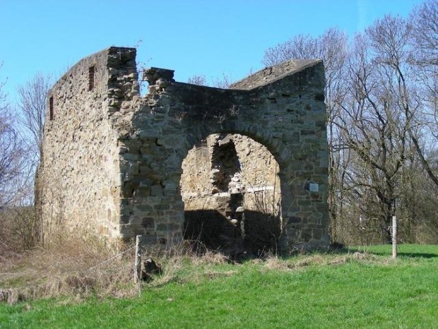
Berchem Castle is first mentioned in 1243 as being in the possession of Dietrich von Berchem. It remained in family ownership until 1450. In 1451, ownership changed hands through marriage to the Lords of Romberg. When Johann von Romberg died in 1615 and his son Philip followed him three years later, his widow Anna Sophia von Romberg offered the manor to Countess Magdalena von Bentheim for 14,500 Rtl. in 1627. However, the purchase did not take place, because in 1628 Johann von Wrede was enfeoffed with the noble seat after he had married the widow von Romberg. Difficult times lay ahead for the noble family and the settlement that had emerged in Carolingian times not far from the noble seat. In 1634, Hessian armies plundered Berchum so thoroughly that afterwards there were neither horses nor cows and sheep left in the village. The Hessians had set up their camp "Am-Öden-Berge", not far from the current property of Armin Gräwener, Garenfelder Weg. Due to the hardships of war, plague and other epidemics, the population was severely decimated. According to a list from 1654, 7 ploughs with 27 farmers and cottagers are listed for Berchum. In 1762, the number of inhabited houses was 38. This increased to 63 houses with 274 inhabitants by 1786.
When Gerhard Moritz von Kettler married Klara von Wrede in 1689 and thus came into possession of Haus Berchum, a large part of the properties belonging to the estate had already been sold due to the accumulating burden of debt. Neither the new owner nor his successors succeeded in overcoming the debt burden. The once stately landed property dwindled away. Out of necessity, the von Kettler family sold the remains of the noble seat to the then merchant Moritz Schmidt in 1792. This Schmidt, once a teacher in Berchum, was one of the most interesting personalities of those times. In 1779, he received 120 Rtl. back from the County of Limburg, which he had lent to it during the "Seven Years' War". Of all creditors, Schmidt was in third place with this sum. In 1793, the Elsey Abbey acquired Haus Berchum for only 340 Rtl. and thus gained a seat and vote in the Limburg Landtag, which was denied to Schmidt, as a non-noble, making the manor uninteresting for him. After the dissolution of the abbey by Napoleon, it fell to the ruling House of Limburg. Today it is deleted from the matricula (castle list) of manors; a meager remnant indicates the site where the noble seat of Berchum once stood.
During a division of the "Berchumer Mark" in 1796 into a Berchum and Tiefendorf Fasel (territorial section), a civil status list was drawn up, in which the population and occupation of the then population of the parish are recorded. According to this, 196 people are listed for Berchum, including 19 Jews, and 59 people for Tiefendorf. It is significant that, besides the farmer, the profession of linen weaver is the most common. However, since the first mechanical weaving mill had already started operations in Scotland in 1794, this profession has been completely abandoned in this area. The last active hand weaver "Heinrich Fehr" laboriously earned his daily bread with this activity until about 1880. Today's street name Linnufer owes its name to linen weaving. Linen was washed in the stone troughs there and laid out to bleach on the Borgmann meadow. However, there are other interpretations. Since it also seems very plausible, I would like to reproduce the interpretation of Dr. Wilhelm Bleicher, Iserlohn, at this point. He says: That the syllable "linn" in Saxon means as much as water or swamp. Our Linnufer was swampy, which was drained by Italians in 1910 and straightened in its form. The Italians were accommodated at that time in the Saale Nippel Im Nordfeld.
After Napoleon put an end to the small states and also dissolved the County of Limburg, Berchum was assigned to the Ergste administrative district. Two place names still in common use point to this time: the Franzosenschlucht (French Gorge) on Berchum's southern border and the Franzosengräben (French Trenches) on the Sauren Egge in Tiefendorf. Although the irregularly laid out trenches, about 200 m long and up to 4 m deep, partly with an access road, and piled up like ramparts, appear to be fortifications, it has not been proven that these were built by the French. The partly mineral-bearing rocks found in the depth of the trenches suggest that ores were mined here. According to another, also unproven interpretation, stones for the Ergste church are said to have been broken here. However, it is also possible that the conglomerate occurring here in large quantities was mined and used for road fortifications. It is interesting in this context that Napoleonic troops were familiar with the place name Tiefendorf. They are said to have asked for a town called Tiefendorf (according to Hermann Esser), which is said to have been located in this area and to have been the victim of a major fire. Tiefendorf may have burned down, about which nothing is known, but Tiefendorf was never a town.
The population of the municipality of Berchum rose to 363 by 1823, including 30 Jews. A Jewish cemetery was laid out on the Lichtenböcken, not far from the current water tower. But already 100 years later, no Jew was left in the municipality. According to Hermann Esser, the so-called Jewish churchyard is a Saxon ring fort of smaller dimensions. In his opinion, no Jews were ever buried there. Berchum had 650 inhabitants at the beginning of the First World War; 33 fallen soldiers were to be mourned by the end of the war. In 1921, Emil Jürgensmann returned home from Russian captivity. He was considered fallen, the death knells had already rung for him. Of the 737 inhabitants at the beginning of the Second World War, 37 died by enemy action (fallen or bomb victims) by the end of the war; not counted are the Poles housed in a barracks in Küsterskamp, 9 of whom died from enemy shellfire (April 13, 1945). During a night bomb attack on Hagen on October 1, 1943, our municipality was affected. Due to numerous high-explosive and incendiary bombs, which fortunately mostly fell on uninhabited areas, 10 houses were severely damaged and 3 were completely destroyed. The stream of refugees and displaced persons that began after the war also reached our municipality. 280 of the mostly Silesian-born suffering people were forcibly quartered in Berchum. Their integration took place relatively quickly. It is significant that the citizens of the municipality already elected Willi Koschwitz, who came from Silesia, as their mayor in 1948. Today, about 50 years later, it can be said that the people who were forced to leave their ancestral homeland played a decisive role in the reconstruction and further development of their new homeland.
Berchum lost its independence in 1975 as part of the reorganization planned and carried out for the Paderborn - Sauerland region. Unfortunately, the municipality's desired merger with the city of Hohenlimburg did not materialize. The territorial change agreement concluded by the municipal council with the city of Hohenlimburg on April 28, 1969, was declared invalid. In addition to the planned expansion of the Lenne line (gaining industrial land by straightening and damming the riverbed), the mostly southwest-facing slopes of Berchum are of municipal political importance, as they are particularly suitable for residential development.
Take Mobile History with you
You are reading this text for free. Premium adds what matters on the road: descriptions read aloud, sites found through your camera, whole regions taken offline.
- Every description, including the ~17,700 Premium sites
- Audio guide: have descriptions read to you on location
- AR finder: see sites through your camera, with distance and bearing
- Unlimited saved sites
14 days free, then from €2.99 a month. Cancel anytime.
Source: Wikipedia · Licence: CC BY-SA 4.0 · Image: http://www.wehrbauten.de/thread.php?threadid=862
This description draws on the facts documented in the linked Wikipedia article; Wikipedia content is licensed under CC BY-SA 4.0. Wording and editing: Mobile History.
Location: 51.3827, 7.5356