The remains of the castle can be visited
CastleSpringe-Bennigsen
Bennigsen Castle
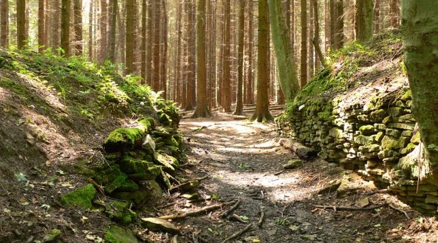
The Bennigser Burg, also known as Meinser Burg, was an early medieval ring fort whose remains are located on the eastern side of the Deister near the Springer district of Bennigsen in Lower Saxony. The hillfort on a ridge probably served as a refuge for the population. An excavation in 1937 dated the complex to the 10th century.
Location+
The former fortification is located at the southeastern end of the Deister, two kilometers southwest of Bennigsen and about 300 m east of the B 217. It was strategically placed on a ridge, like a hilltop castle. Its ramparts, starting from the main castle at the top, sloped downwards. On two sides, two deeply incised, gorge-like stream courses provided natural protection. The rampart complex was located near old trade routes. This included the Königsweg, which led to it as a ridge path from the Deister ridge. In the plain below the complex, to the east, ran the Hameln–Hannover military road, connecting the Leine valley with the Weser valley. The castle is oriented in this direction with its gate openings. Today, the entire area is covered with dense coniferous forest, which prevents an overall view. Near the castle on the eastern slope of the Deister, numerous prehistoric burial mounds can be found.
Description+
Of the fortification, earth ramparts 3 to 5 m high are still present today. It can be assumed that the ramparts were formerly fronted by a several-meter-high wall of stones or wooden logs. Although there has been no more precise archaeological investigation to date, this is to be assumed due to the construction method of similarly designed complexes (Isenburg, Wirkesburg, Heisterburg) from the same period in the vicinity.
The core of the rampart complex is located at the highest point of the ridge. It consists of a walled rectangle measuring 140 x 160 m. On the slope below, there is an outer bailey measuring 100 x 185 m. With a total walled area of approximately 4 hectares, the Bennigser Burg is one of the larger complexes of its kind in the area. Approximately 100 m down the slope from the outer bailey, there is a 230 m long outer rampart with a ditch. Since there are no side ramparts, the flanks may have been secured with palisades or hedges in the past.
Excavation+
A limited archaeological investigation took place on the grounds of the hillfort in 1937. It was limited to the remains of a gate between the main castle and the outer bailey. The good state of preservation of the discovered wall remains allowed for a drawn reconstruction of this part of the complex. Further investigations inside the rampart complex, which could provide clues to earlier settlement, have not been carried out to date.
Investigated Gate
During the excavation, only the immediate area around a former gate was investigated. The gate area with its lateral wall cheeks was reconstructed and left in place, so that today's visitor gets an idea of the former entrance. The gate was located in the rampart that separated the main castle from the outer bailey. The gate opening consisted of a 3 m wide and approximately 15 m long gate passage. The passage led out of the main castle and was formed by stone walls. The walls consisted of limestone slabs joined with loam and clay. Remains of wooden posts in the center of the gate area suggested an overbuilding with a wooden gate tower. On the stone pavement of the gate passage lay shards of ceramic vessels from the 10th century, on which the dating is essentially based. In addition, the further securing of the main castle towards the outer bailey in this area was investigated. It consisted of a double pointed ditch, over which an earthen bridge existed in the area of the gate access.
On maps from the 16th to 18th centuries, the Bennigser Burg was called "Meiner Burg". The current name is probably due to its proximity to Bennigsen. During the 9th and 10th centuries, the presumed period of the complex's creation, there was a larger manorial estate in this village (first mentioned in 969), whose representatives could be considered as builders. Due to its size and structure, the only possible function of the rampart complex is that of a refuge for the population in times of danger.
Take Mobile History with you
You are reading this text for free. Premium adds what matters on the road: descriptions read aloud, sites found through your camera, whole regions taken offline.
- Every description, including the ~17,700 Premium sites
- Audio guide: have descriptions read to you on location
- AR finder: see sites through your camera, with distance and bearing
- Unlimited saved sites
14 days free, then from €2.99 a month. Cancel anytime.
Source: Wikipedia · Licence: CC BY-SA 4.0 · Image: http://de.wikipedia.org/wiki/Bennigser_Burg#mediaviewer/Datei:Bennigser_Burg_Torgang.jpg
This description draws on the facts documented in the linked Wikipedia article; Wikipedia content is licensed under CC BY-SA 4.0. Wording and editing: Mobile History.
Location: 52.2303, 9.6344