The remains of the Castle can be visited
CastleBuch
Balduinseck Castle
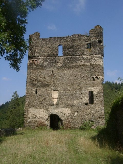
Balduinseck Castle, also known as Baldeneck, is the ruin of a hilltop castle on a slate cone only about 20 meters high in a valley of the Hunsrück at the confluence of the Wohnrother Bach and the Schumbach, forming the Mörsdorfer Bach, within the municipality of Buch in the Rhein-Hunsrück-Kreis in Rhineland-Palatinate.
In 1325, Archbishop Balduin of Trier acquired the right to demarcate a castle peace and erect a castle on the territory of the knights Richard and Wirich von Buch. This new complex was primarily directed against Kastellaun Castle of the County of Sponheim. In constructing the complex, Balduin seems to have been inspired by Western models, particularly the French donjon type.
The castle served as the administrative seat of the Trier administrative district of the same name. In the 16th century, the administrative seat was moved to Zell, rendering the castle largely insignificant. There are no exciting events surrounding the castle. The owners or administrators changed frequently, as Balduinseck essentially always remained a part of the Trier Electorate.
In 1675, the administrative building was leased. In 1711, the castle was described as neglected, and in 1780, as dilapidated. No destruction appears to have occurred due to wars.
Architecture+
The outer walls of the still 18-meter-high and four-story residential tower are well preserved and form the striking appearance of the ruin. The residential tower has a footprint of 22.7 x 14.4 meters and a wall thickness of up to 2.5 meters. Still preserved are a spiral staircase, which, like the nine remaining fireplaces, extends over all four floors, as well as the white, increasingly defaced interior plaster and a white strip of the former exterior plaster between the third and fourth floors. The ruin is approximately 55 meters long in the east-west direction and up to 20 meters wide. The special feature of the castle is the location of the residential building. Contrary to the usual castle layout, the residential tower stands behind the neck ditch, directly on the attack side. Such an arrangement can be found in other castles of Balduin of Luxembourg (cf. Baldenau Castle).
In front of the residential tower are still the remains of the curtain wall and a round tower to the west. Furthermore, the old access road with a neck ditch and associated bridgehead can still be recognized. To the east are the remains of a second ditch with the foundations of an advanced tower.
Present+
Balduinseck Castle, threatened by collapse, is being secured. Parts of the castle's foundation are completely dilapidated and can no longer withstand the immense pressure of the mighty masonry. Increasingly large cracks prove that the entire ruin is in motion. The structure is acutely endangered; there is a risk of collapse.
For this reason, the ruin underwent comprehensive securing from summer 2009. The work was divided into five construction phases and was completed in 2014.
Future+
In a historical network, the three Trier Electorate castles of Baldenau, Balduinseck, and Rauschenburg, as structural testimonies to Balduin's expansionist policy in the Hunsrück, are to be connected with the Rhenish cities of Boppard and Oberwesel, which belonged to the Archbishop's territory, via the Balduinsweg from the Hunsrück to the Rhine.
Take Mobile History with you
You are reading this text for free. Premium adds what matters on the road: descriptions read aloud, sites found through your camera, whole regions taken offline.
- Every description, including the ~17,700 Premium sites
- Audio guide: have descriptions read to you on location
- AR finder: see sites through your camera, with distance and bearing
- Unlimited saved sites
14 days free, then from €2.99 a month. Cancel anytime.
Source: Wikipedia · Licence: CC BY-SA 4.0 · Image: http://de.wikipedia.org/wiki/Burg_Balduinseck#mediaviewer/Datei:Balduinseck_western_front.JPG
This description draws on the facts documented in the linked Wikipedia article; Wikipedia content is licensed under CC BY-SA 4.0. Wording and editing: Mobile History.
Location: 50.0764, 7.3632