The Ruin can't be visited
CastleArgenschwang
Argenschwang Castle
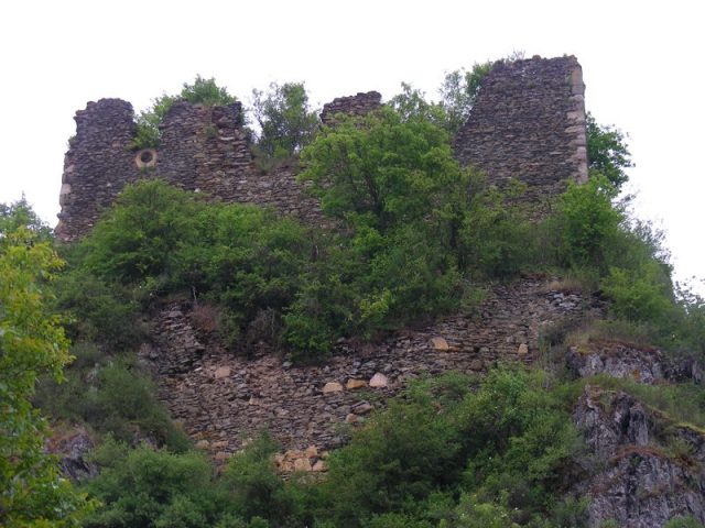
Argenschwang Castle, popularly known as Rosenburg since the 19th century, is the ruin of a hilltop castle at an elevation of around 295 m above sea level in the municipality of Argenschwang in the district of Bad Kreuznach in Rhineland-Palatinate.
The early history of the castle is unknown; based on its construction style, it was built during the Late Middle Ages, probably during the first half of the 14th century. A mention for the year 1195 refers only to the place itself and also dates from a later period. The first reliable mention of Argenschwang Castle dates from June 19, 1332, when it was named in three documents on the occasion of the endowment of Perpetual Masses ...under the castle Arinswank in the St. Martin's Chapel. The castle complex was at this time in the possession of Count Johann II of Sponheim-Kreuznach, who enfeoffed the castle to his illegitimate son Simon von Argenschwang. In 1416, the Lords of Leyen were enfeoffed with the castle, and in addition, one-fifth of the complex passed from Countess Elisabeth of Sponheim-Vianden to Count Palatine Ludwig III the Bearded.
After the extinction of the Counts of Sponheim in 1437, Argenschwang Castle came into the possession of several owners, the heirs of the Sponheimers, the Margraves of Baden, the Electorate of the Palatinate, and the Principality of Palatinate-Simmern-Zweibrücken. The feudal tenants of the castle continued to be the Lords of Leyen until 1757, after which the Lords of Hohenecken were also added. In 1783/85, Margrave Karl Friedrich of Baden bought the castle and lordship for 52,500 guilders.
The castle was destroyed in the First Coalition War in 1793, and later, during the 19th century, it was auctioned off as French national property. In 1929, there were plans to rebuild the complex, but these were not implemented. In 1977, it was sold to private owners. The castle ruin is not publicly accessible.
Architectural Description+
The present castle ruin is located on a mountain spur projecting to the west, immediately east above the village of Argenschwang. On this spur, the castle was naturally well protected on three sides by the steep slopes of the mountain, only to the east a wide neck ditch had to be laid out for its security. Access to the castle ran along the northern side of the mountain, crossed the ditch, and led to the gatehouse, which is still preserved today.
Argenschwang Castle was formerly divided into two areas: on the northern, slightly lower part of the mountain spur lay an elongated outer or lower bailey, while the remaining rocky area was occupied by the rectangular main castle.
No buildings of the lower bailey have been preserved apart from the gatehouse. This three-story and T-shaped building (cover picture) dates from the 17th century, and the basket-arched passage runs through it. Above this passage is an embedded coat of arms, which probably belonged to Eberhard von Leyhen († 1675). The upper floor of the gatehouse is accessible via a spiral staircase in the southwest corner of the building.
The main castle has a rectangular floor plan, its access was probably on the north side. Only a few meters high wall remains have been preserved from it, and the terrain is now heavily overgrown with bushes, making an overview difficult. At the tip of the mountain spur, in the safest place, was the main residential building of the castle (picture 2). This building was constructed of rubble masonry with corner quoins; a round window opening framed by ashlar stones has been preserved to the west. This building is also visible in an illustration from before 1629. Another building, as excavations in the 1820s show, was located in the south of the main castle and projects a few meters from the curtain wall. The remains of a vaulted cellar room have been preserved from it. It is possible that this building was only built at a later time. Above the neck ditch on the attack side of the castle, a tall structure once stood, which was either a residential tower or a shield wall. This structure was additionally reinforced by two corner turrets. At a later time, probably during the 17th century, a bastion-like projecting, pentagonal structure was added to this building, one point of which faces the neck ditch.
Take Mobile History with you
You are reading this text for free. Premium adds what matters on the road: descriptions read aloud, sites found through your camera, whole regions taken offline.
- Every description, including the ~17,700 Premium sites
- Audio guide: have descriptions read to you on location
- AR finder: see sites through your camera, with distance and bearing
- Unlimited saved sites
14 days free, then from €2.99 a month. Cancel anytime.
Source: Wikipedia · Licence: CC BY-SA 4.0 · Image: http://www.wehrbauten.de/thread.php?threadid=1340
This description draws on the facts documented in the linked Wikipedia article; Wikipedia content is licensed under CC BY-SA 4.0. Wording and editing: Mobile History.
Location: 49.8808, 7.7006