The remains of the Castle can be visited
CastleAltenbaumburg
Altenbaumburg Castle
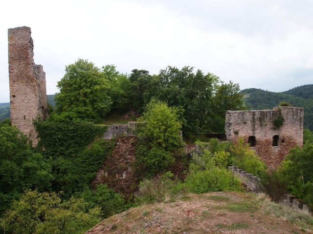
Altenbaumburg is the ruin of a spur castle on a ridge above the village of Altenbamberg in the Alsenz Valley, Rhineland-Palatinate. It is the ancestral castle of the Raugraves and one of the largest castle ruins in the Palatinate. Originally situated in a strategically favorable position in the Alsenz Valley, the complex lost its significance after its owners, the Raugraves, died out in the 14th century.
There is no information about the exact time of its construction. The commonly cited first mention of Altenbaumburg in 1129 is a forgery. Even a Count Emich von Baumburg, known since 1154, cannot be used with absolute certainty as proof for Altenbaumburg, as his surname could derive from a castle or a settlement. Since even the division of the Raugrave lineage into two different lines in 1214 provides no clarification in this regard, one can only refer to a document from 1253, in which a "New Castle" near the now vanished village of Sarlesheim is mentioned for the first time. This complex was the Neuenbaumburg, now called Neubamberg, which makes it clear that there must have been an Altenbaumburg at the latest by then.
By 1317, several owners could already be documented, which clearly indicates financial difficulties for the count's family. The privileging of the valley settlement with Oppenheim city rights and market rights by King Louis the Bavarian in 1320 did little to change their decline. Due to internal family inheritance disputes and financial problems, the Raugraves were forced from the mid-14th century to grant the Count Palatine of the Rhine and the Counts of Sponheim the right of access. In 1366, individual buildings, especially the entire middle castle, were pledged to the Palatine Counts, who managed to unite three-quarters of the castle in their hands by 1457. The remaining quarter came into the possession of the House of Palatinate-Simmern by indirect means at the same time. At the beginning of the 16th century, the Palatine Counts granted the castle as a Palatine and Palatinate-Simmern hereditary fief to various noble families, who sometimes appointed their own officials.
Apparently, parts of Altenbaumburg were already uninhabited and falling into disrepair by the end of the 15th century. In 1482, Schweikard VIII von Sickingen was allowed, with Palatine permission, to transport stones from there as building material for his new construction of Ebernburg. During the Thirty Years' War, Spanish and Swedish occupation troops were stationed in the remaining castle buildings in 1621 and 1631. In 1666, the castle was conquered by the Palatine Elector Karl I Ludwig in his campaign against Lorraine. A complete reconstruction or even just the maintenance of the existing buildings seems not to have taken place, as a written source in 1681 referred to the castle only as a ruin. The certainly still quite impressive buildings at that time were finally devastated in 1689 by French troops. A thorough renovation took place in the years from 1980 to 1986.
Architecture+
The 200 by 40 meter ruin of Altenbaumburg consists of three separate complexes, whose structural remains largely date from the 14th and 15th centuries. The silhouette of the entire complex, formerly characterized by only a few striking individual features, is now dominated by a rebuilt residential building at the end of the mountain spur.
The best preserved part in the eastern, trapezoidal upper castle is the shield wall with a former height of about 15 meters and a thickness of just over one meter. This wall, probably dating from the first half of the 14th century, is bordered in the northeast by a slightly higher, three-quarter round corner tower and in the southeast by an 18-meter high rectangular tower with remnants of a latrine system and a chimney shaft inside. A rubble mound, under which the stump of the rectangular keep with ashlar blocks from the early 13th century was uncovered, now dominates the former castle courtyard. According to a copper engraving from before 1629, the tower may have been about 40 meters high, making it one of the most powerful of its kind. What remains is a four-meter high section of wall on the nine-meter long northwest side, executed in ashlar blocks.
With a width of about 40 meters, the upper castle, with its shield wall and the moated ditch in front of it, now spanned by an iron bridge from the late 19th century, shielded the entire remaining part of the castle area from the mountain side. The middle and lower castles steadily narrow to a width of 25 meters at the mountain peak.
The middle castle, with an area of 20 by 30 meters, is the smallest of the three castle parts. Towards the upper castle, it is enclosed, flanked by a round tower, by a shield wall, now rising only to chest height above the courtyard level, with a moat in front. The curtain wall crowns have been heavily restored. Apart from the gable wall of a two-story house, only a few spolia have been preserved, including profiled fireplace surrounds and window niches.
The Gothic lower castle reaches its greatest extent with a length of about 50 meters. On the foundations of a large building that was integrated into the curtain wall, a palace-like building was erected from 1981 to 1983, which now houses the castle restaurant. During these works, the former latrine shaft was converted into a bay window, and an octagonal stair tower, also previously non-existent, was added in front of the freely supplemented courtyard-side wall. In the castle courtyard, in addition to the alleged, but not specifically documented, castle chapel with a supplemented round arch and late Gothic vault beginnings, there is also a cellar access and a well shaft. Some column bases serve decorative purposes in the restaurant's guest room.
Take Mobile History with you
You are reading this text for free. Premium adds what matters on the road: descriptions read aloud, sites found through your camera, whole regions taken offline.
- Every description, including the ~17,700 Premium sites
- Audio guide: have descriptions read to you on location
- AR finder: see sites through your camera, with distance and bearing
- Unlimited saved sites
14 days free, then from €2.99 a month. Cancel anytime.
Source: Wikipedia · Licence: CC BY-SA 4.0 · Image: http://www.wehrbauten.de/thread.php?threadid=1340
This description draws on the facts documented in the linked Wikipedia article; Wikipedia content is licensed under CC BY-SA 4.0. Wording and editing: Mobile History.
Location: 49.7860, 7.8345