The remains of the Castle can be visited
Castleeutschfeistritz-Waldstein
Alt-Waldstein Castle
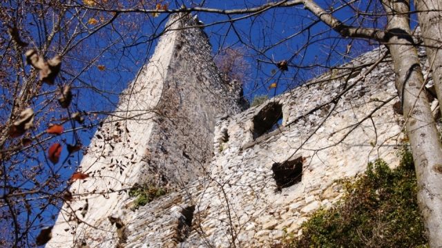
Waldstein Castle, also known as Alt-Waldstein Castle, is a ruined castle located in Deutschfeistritz in Styria. Its history dates back to the 12th century. It was left to decay in the first half of the 16th century.
The ruins of the hilltop castle stand on an offshoot of the Schankkogel, running from east to west towards the Arzwaldgraben, north of the cadastral community of Waldstein, which belongs to Deutschfeistritz. The offshoot drops almost vertically to the north and less steeply to the east and south. Access to the castle runs from the west, south below the castle. The castle secured the transition from the Gleinalpe to the Upper Mur Valley.
Waldstein Castle was probably built towards the end of the 11th century by the noble family of St. Dionysen. The first documented mention as "castrum waldstein" dates from 1152. From 1190 to 1305, the castle was owned by the Lords of Wildon. They were followed by the Lords of Walsee as castle lords, who expanded the castle into a fortress. The Walsee family handed over the property to the Counts of Cilli in 1363, who resided at the castle until 1436. After them, the fortification passed to the Pernegger family until 1468. After 1468, the Windisch-Graetzer family were the castle lords of Waldstein, who expanded and modernized the castle. After the construction of Waldstein Palace began in the first quarter of the 16th century, the importance of the castle waned and it was left to decay.
The first part of the castle complex was probably built in the 12th or 13th century in the elevated northeastern part. This was expanded in the 14th century with the keep, the castle chapel, the palas, and the curtain wall. The zwinger systems date from the 15th and 16th centuries.
Design+
Along the former access road to the castle are two gates, only partially preserved today. This access leads into an approximately rectangular courtyard, open to the west, in the southeastern part of the castle. In the southeastern part of this courtyard is a round tower with keyhole embrasures. Somewhat below the courtyard are extensive zwinger systems accessible through a gate. North of it is a rectangular flanking tower projecting from the wall line, and to the south are the remains of a former farm building. The access turns in the courtyard and leads over a brick ramp and a drawbridge, no longer preserved today, to another, third gate. Only the support stones of the drawbridge remain. Extensive outworks were formerly located on the eastern and southern slopes of the castle hill.
The main castle is surrounded on the north, east, and south by a curtain wall, partly running along the edge of the plateau, while in the west, the triangular keep forms the end. In the east of the northern section of the curtain wall, a three-part building was probably added in the second half of the 15th century. Piles of rubble in this area probably come from buildings from the 12th century. West of it are the remains of the castle chapel, built against the curtain wall, with the oriented Romanesque apse, vaulted by a semi-dome and illuminated by three round-arched windows. Its Gothic pointed-arch portal with shell limestone jambs still stands today. On the northern and southern chapel walls, a narrow, round-arched slit window is preserved in a poorly built round-arched niche. In the west, a single-room structure is attached to the chapel, and in the east, there is a staircase system via which the upper floor of the chapel and that of the attached structure were accessible.
The sharp edge of the triangular and five-story keep in the west of the complex has a 2-meter-thick wall and faces outwards, towards the attackers. It features a rough, irregular rubble masonry, indicating its origin in the 14th century, and served purely as a defensive structure. The former access to the tower was in the eastern part of the second upper floor and was via the castle courtyard. One floor below, there was another gate, which is now walled up. On the ground floor, there is now a wall breach, probably of more recent origin, through which the keep can be entered. Each of the floors is illuminated by narrow light slits and was formerly connected by ladders or wooden stairs. None of the intermediate ceilings have been preserved.
In the small castle courtyard is a cistern. East of the keep is a three-story hall building, placed against the southern curtain wall, which was probably the palas. On the southern wall of the first upper floor are three wide windows with side seats. The northern, western, and eastern walls have a thickness of 40 to 60 centimeters, indicating a former wooden plank room or blockwork chamber. The large, rectangular windows of the building could formerly be closed with wooden sliding shutters.
Somewhat away from the actual castle are the square residential tower, also known as the "Hungerturm" (Hunger Tower), and a surrounding curtain wall. This can be considered an outer bailey.
Take Mobile History with you
You are reading this text for free. Premium adds what matters on the road: descriptions read aloud, sites found through your camera, whole regions taken offline.
- Every description, including the ~17,700 Premium sites
- Audio guide: have descriptions read to you on location
- AR finder: see sites through your camera, with distance and bearing
- Unlimited saved sites
14 days free, then from €2.99 a month. Cancel anytime.
Source: Wikipedia · Licence: CC BY-SA 4.0 · Image: http://www.wehrbauten.at
This description draws on the facts documented in the linked Wikipedia article; Wikipedia content is licensed under CC BY-SA 4.0. Wording and editing: Mobile History.
Location: 47.2304, 15.2831