Cultural Events
CastleWittenburg
Wittenburg Castle
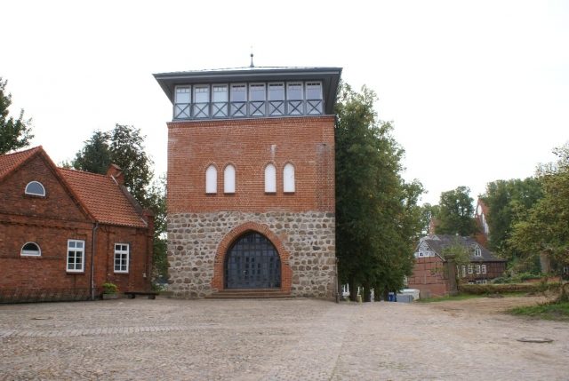
At the beginning of the 12th century, Wittenburg belonged to the territory of the Polabian sub-tribe of the Abodrites. In 1142, Henry the Lion enfeoffed the Saxon Count Henry of Badewide with the land of the Polabians, which was soon referred to as the County of Ratzeburg after its main town. Initially, this did not change the cultural, economic, and religious traditions of the Wends. Only in the course of the Wendish Crusade was the Slavic castle complex in Wittenburg likely destroyed, and subsequently, a small German settlement emerged as a border station to the neighboring territory of the Abodrites. This was razed in the autumn of 1158 by an Abodrite contingent under Pribislaw and Wertislaw, who, with the successful raid, extorted the release of their father Niklot, imprisoned by Henry the Lion in Lüneburg. After Niklot's death in 1160, under the leadership of the Old Saxon noble family of the Witten, the castle was rebuilt to provide military backing to the German exclave in Schwerin and the bishopric newly established there under Berno. At the foot of this castle, a settlement re-emerged where craftsmen and traders settled. There may also have been initial tentative settlements of German colonists, even though the vast majority of the population were Polabians. Thus, the new castle formed the starting point for the later founding of the city of Wittenburg.
The founding of the city of Wittenburg is not clearly documented. In 1194, Wittenburg was mentioned as a "provincie" of the County of Ratzeburg in the Isfried Partition Treaty. On May 25, 1201, a battle took place near Waschow between the Ratzeburg and Schwerin counts, during which the castle surrendered without a fight. The land and city of Wittenburg fell to the victorious County of Schwerin three years later by order of the Danish King Waldemar II. Only under the new counts, the brothers Gunzelin II and Henry I (Schwerin), did significant settlement begin. In 1226, Emperor Frederick II granted the city of Lübeck imperial freedom and secured its unhindered trade with Hamburg, Schwerin, Ratzeburg, and Wittenburg. This date also stands for the founding of the city of Wittenburg, although it may have occurred earlier. In 1230, Wittenburg was finally listed as a "civitas" in the Ratzeburg Tithe Register, which lists the localities then belonging to the Diocese of Ratzeburg, ordered by parish. In Alt-Wittenburg, the Lübeck city law, confirmed in 1319, prevailed.
In 1282, Wittenburg was the capital of an independent county that stretched from the Elbe near Boizenburg to beyond Crivitz. This period of the Wittenburg counts, the city's heyday, lasted approximately seventy years, as the town flourished economically due to active trade relations with Lübeck. During this time, defensibility played a crucial role. Remains of the former fortifications still bear witness to the strength of these structures; the Mühlen Gate was demolished in 1850 and the Stein Gate in 1869.
The city of Wittenburg fell to the Mecklenburg dukes through purchase in 1358. For many years, the castle complex served them as an emergency camp and secondary residence, later as the residence of princely widows. In 1496, the city had 500 to 600 inhabitants. Towards the end of the 16th century, Duchess Sophia stayed at Wittenburg Castle several times. The energetic duchess advocated for the introduction and promotion of the iron industry. By utilizing the bog iron ore found in the area, she established iron smelting and hammer works, thereby attempting to raise the city's prosperity. These works disappeared again after the Thirty Years' War.
Thirty Years' War and After
Even during the Thirty Years' War, Wittenburg was under the protection of Duchess Sophie, as she obtained letters of protection. Wittenburg was not involved in combat operations in the first years of the war, but constant efforts to defend the city and the associated taxes and levies wore down the inhabitants. The plague raged terribly in the city in 1629/1630. In the following years, military actions also spread to Mecklenburg. The citizens of Wittenburg repeatedly suffered quartering and looting. The worst day, however, was February 1, 1642, when Croats stormed the city and wreaked terrible havoc. In 1644, only about 100 citizens still lived in the city.
In 1657, almost the entire city, including the town hall, church roof, and bell tower, burned down, except for three houses. Further city fires raged in 1679 and 1726.
In 1735, the city and the Amt of Wittenburg, along with seven other Amts, were pledged by Duke Christian Ludwig II to the Electorate of Brunswick-Lüneburg. This was the result of the imperial execution caused by Christian Ludwig's brother Karl Leopold. A Lüneburg occupation force remained in the city for 33 years. Only in 1768 were these parts of the country redeemed for one million thalers. A motif on Wittenburg's emergency money shows the convoy with the redemption sum.
During the occupation by Napoleon Bonaparte, the "French period," which began in November 1806, the people of Wittenburg suffered particularly. The city was located on the main military road between Boizenburg and Schwerin, making it a particularly favorable station for incessant troop movements and quartering.
In 1848, a neoclassical administrative building was erected on the castle grounds. From 1998 to 2000, the gate tower of the old castle was renovated.
Take Mobile History with you
You are reading this text for free. Premium adds what matters on the road: descriptions read aloud, sites found through your camera, whole regions taken offline.
- Every description, including the ~17,700 Premium sites
- Audio guide: have descriptions read to you on location
- AR finder: see sites through your camera, with distance and bearing
- Unlimited saved sites
14 days free, then from €2.99 a month. Cancel anytime.
Source: Wikipedia · Licence: CC BY-SA 4.0 · Image: Roland Neubert, Halle (Saale)
This description draws on the facts documented in the linked Wikipedia article; Wikipedia content is licensed under CC BY-SA 4.0. Wording and editing: Mobile History.
Location: 53.5139, 11.0723