The remains of the Castle can be visited
CastleAremberg
Aremberg Castle
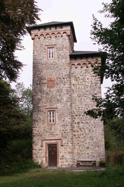
Aremberg Castle near Aremberg in the Rhineland-Palatinate district of Ahrweiler is the ruin of a medieval hilltop castle on the Aremberg in the Ahrgebirge (Eifel).
The ruin is located on the densely forested Aremberg (623.8 m above sea level), one of the largest Tertiary volcanoes in the Eifel, in the area of the municipality of Aremberg. The village itself is located on the western slope of the mountain, below the summit.
Castle Complex+
It was first mentioned in 1166, then under the name "Arberg". In the 12th century, a castle was built on the mountain, as this location was strategically favorable.
Aremberg Castle was the center of the immediate imperial lordship of Arenberg, whose family still flourishes today in Belgium and South America and possesses great wealth. Although the lordship was very small in terms of area, numerous family members managed to exert great influence at the Viennese court, so that the family rose from counts to princes and finally to dukes. The (sparse) remains of the castle preserved today hardly bear witness to this former splendor.
After this social ascent, the complex was expanded over more than 18 years into a fortified fortress of gigantic proportions, which by around 1670 covered the entire Aremberg. It was so massive that it was spared even by the troops of Louis XIV, who did not dare to attack it, as it was considered impregnable. In 1679, after the Peace of Nijmegen, the Duke dismissed his garrison troops, which proved fatal. Three years later, the castle, now almost defenseless, was taken by French troops. The French planned to further expand the fortress and use it themselves. However, a serious accident occurred when an incorrectly executed blasting operation significantly altered the water balance of the Aremberg. As a result, all the castle's wells dried up. Therefore, the occupiers left this location after only one year. They rendered the fortress itself unusable through large-scale demolitions.
Palace+
Around 1720, the complex was rebuilt by the Dukes and converted into a palace. On October 13, 1794, the next setback occurred. As a harbinger of the French revolutionary troops, a French soldier demanded the billeting of his general, a commissioner, and several officers in the palace. Thereupon, the ducal family vacated the estate and moved to the Netherlands. Finally, in 1803, Jean Gaspard Villmart bought the "Palace on the Aremberg" and had it demolished in 1809. Remains from all construction periods are preserved, such as the moat with wall, bastions of the fortress, and twelve lime trees from the former palace garden.
Observation Tower+
Gottfried Kinkel visited the field of ruins a few years after the demolition, and this sight, as well as the bitter poverty of the Aremberg population, filled him with pain, for the once flourishing village had become a miserable one. He later reported on this in his book Die Ahr (1846). In 1854, an observation tower was erected on the site of the former castle, which stands near a 623.0 m high mountain point and consists of stones from the former castle complex. Due to tree growth, it has not been usable as an observation tower for decades. Likewise, the museum formerly located within it no longer exists. The tower is now locked.
Take Mobile History with you
You are reading this text for free. Premium adds what matters on the road: descriptions read aloud, sites found through your camera, whole regions taken offline.
- Every description, including the ~17,700 Premium sites
- Audio guide: have descriptions read to you on location
- AR finder: see sites through your camera, with distance and bearing
- Unlimited saved sites
14 days free, then from €2.99 a month. Cancel anytime.
Source: Wikipedia · Licence: CC BY-SA 4.0 · Image: http://de.wikipedia.org/wiki/Datei:Ruine_Arenberg.jpg
This description draws on the facts documented in the linked Wikipedia article; Wikipedia content is licensed under CC BY-SA 4.0. Wording and editing: Mobile History.
Location: 50.4171, 6.8141