The remains of the castle can be visited
CastleVorra-Düsselbach
Düsselbach Castle
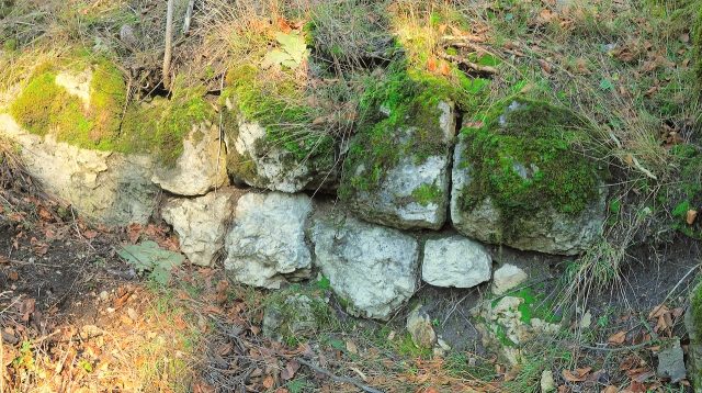
The Burgstall Altes Schloss was a former, presumably High Medieval noble castle west of the village of Düsselbach in the municipality of Vorra in the Middle Franconian district of Nürnberger Land in Bavaria, Germany.
The Burgstall of the hilltop castle is freely accessible and serves as a viewpoint.
Geographical Location+
The former castle is located in the southern part of the Franconian Switzerland-Veldenstein Forest Nature Park at an altitude of 567 m above sea level on a rocky elevation of a ridge between the Pegnitz valley to the east and the Sittenbach valley to the west, about 1700 meters west of the village of Düsselbach, approximately 30 kilometers northeast of the city of Nuremberg.
The Burgstall can be reached by following a hiking trail marked with a horizontal yellow stripe southwards on the road from Vorra to Stöppach. The path leads directly past the Burgstall.
Other medieval fortifications were located nearby: Burg Hohenstein to the north-northwest, Burgstall Kleiner Hansgörgel on the mountain of the same name near Hersbruck to the southwest, and the castle ruin Lichtenstein above Pommelsbrunn to the southeast.
History of the Castle+
There are no historical records about the former castle. The time of its construction, the builder, and even the name of the castle are unknown. An assignment to the ministerials of Alfalter, who belonged to the service retinue of the Reicheneckers, is conceivable. They can be traced from 1362 to 1433. Whether the castle was abandoned after the extinction or migration of the lords of Alfalter, or whether it was destroyed in a warlike conflict, is unknown. Ceramic remains found so far date the rather small castle to the 13th century. Walter Heinz suggests an origin as early as the 11th or 12th century.
A first mention of a castle at this location only appears in 1596 on a map by the Nuremberg cartographer Paul Pfinzing. He referred to the spot as "Bei dem alten Schlosssteinhügel" (At the old castle stone hill).
The purpose of the castle could have been to monitor a crossroads of two ancient roads. One road led from Hersbruck via Großviehberg and Hohenstein to Betzenstein, a second from Kirchensittenbach to Düsselbach. They crossed very close to the former castle on the ridge.
Description of the Burgstall+
The ridge at the site of the former castle forms a mountain ridge in a north-south direction with two rock reefs. The castle stood on the plateau of the southern rock reef.
It was a single-part complex on a rocky plateau measuring approximately 24 by 12 meters, and had no outer bailey, which suggests a great age. The plateau drops vertically about four to ten meters to the west (Figure 1) and south, while on the north and east sides (Figure 2) it slopes moderately steeply for about four meters.
The plateau was surrounded by a curtain wall, of which a last remnant of wall with two ashlar courses, each with four ashlars, can still be seen in a rock crevice on the west side (Figure 3). In addition, foundation wall remains are present on the east side. The northern part of the curtain wall is still recognizable as a slope edge. Nothing more can be seen of the southern part.
In the northern leveled part of the castle complex, there was probably a building measuring 10 by 5 meters, which was formed by the curtain wall on the north, west, and east sides. The south side consisted of a transverse wall between the eastern and western curtain walls, which presumably formed the transition to a castle courtyard. A building probably also stood in the south of the castle complex. The terrain in between is rocky; no traces of construction can be seen there.
Access to the castle was probably at the northern end of the plateau and led through the building. A faint depression in the terrain can be seen at the northern and eastern foot of the plateau; a ditch may have been located there.
In the northern and eastern areas of the Burgstall, mortar remains, brick debris, and ceramic fragments can be discovered.
Take Mobile History with you
You are reading this text for free. Premium adds what matters on the road: descriptions read aloud, sites found through your camera, whole regions taken offline.
- Every description, including the ~17,700 Premium sites
- Audio guide: have descriptions read to you on location
- AR finder: see sites through your camera, with distance and bearing
- Unlimited saved sites
14 days free, then from €2.99 a month. Cancel anytime.
Source: Wikipedia · Licence: CC BY-SA 4.0 · Image: http://de.wikipedia.org/wiki/Datei:Burgstall_Altes_Schloss_%28D%C3%BCsselbach%2901.JPG
This description draws on the facts documented in the linked Wikipedia article; Wikipedia content is licensed under CC BY-SA 4.0. Wording and editing: Mobile History.
Location: 49.5525, 11.4558