Apartments
The Castle can be visited
CastleKaiserpfalz-Wendelstein
Wendelstein Castle
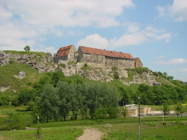
The castle and village of Wendelstein are situated on a hill that drops sharply down to the Unstrut river. Its location on a 30-meter-high gypsum rock makes a castle complex probable for the early Middle Ages as a border fortress of the Saxons against the Franks; it is also debated whether the Ottonian imperial palace of Memleben could have been located here. Wendelstein is located east of Wiehe in Thuringia.
The castle is first documented in 1312 among the posthumous possessions of the Counts of Rabenswalde, as Wendilsteyn in 1322.
It initially belonged to the Counts of Weimar, who had to sell it due to their high debts to the landgrave's court judge Christian von Witzleben. He was responsible for its expansion. The oldest part of the castle, with its sturdy walls and towers, is located in front of the west wing; remains of a Romanesque chapel can also be seen here.
Further conversions into a residential castle took place in 1560 and 1590. The north wing, dating from the late Renaissance period, is only partially preserved but still offers an imposing sight.
The castle complex is surrounded by a stately moat, descending in several stages, which in turn is delimited by a rampart with casemates.
In 1623, Wendelstein came into the possession of Elector Johann Georg I of Saxony.
During the Thirty Years' War, it was devastated by the Pappenheimers in 1632, and by the Swedes in 1632 and 1640, after which only simpler half-timbered buildings were erected.
In the 18th century, a widely renowned horse breeding program emerged, featuring horses of Polish, Turkish, and Tatar breeds.
During the Wars of Liberation, the stud farm was robbed of its horses on May 26, 1813, by Lützow's Jägers under the command of Theodor Körner. The stud farm was not reoccupied; after Wendelstein was ceded to Prussia in 1815, the domain fell into disrepair.
In 2004, the castle was sold. The current owner originally came from Berlin.
Archaeological finds indicated that a Bronze Age hilltop settlement likely existed in Wendelstein. Triggered by the discovery of the Nebra Sky Disk, excavations were carried out in 2006 by the Department of Prehistory and Early History of the Friedrich Schiller University Jena as part of the DFG-funded project "The Dawn of New Horizons. The Finds from Nebra, Saxony-Anhalt, and their Significance for the Bronze Age of Europe." Initially, the focus of the investigations was on the hilltop settlements. Ultimately, twelve sites in the macro-region around Nebra (a radius of 40 km) were also included in the investigations. The aim was to explore the actual appearance of these hilltop settlements and to clarify whether they were central places that, as suspected, served as fortified control points for trade at topographically favorable locations, and whether they represented prestigious symbols of an elevated social stratum. During the excavations in Wendelstein, the rampart structure lining the hollow way and two other geophysically promising locations were specifically uncovered. The stratigraphy of the rampart could be clearly traced. It is formed by a layer beneath the humus, which covers the prehistoric findings and is thus younger than them. Among the findings, an Iron Age storage pit with the skeleton of a goat was uncovered. Other finds indicate that the site was already in use in the late Bronze Age.
Current Use+
In 1981, renovation work was carried out on the castle ruins, and apartments were set up in the still-preserved buildings of the west wing and the south wing facing the Unstrut.
The once formidable appearance is now softened by lush green growth; the rampart and moat are overgrown with grass and lined with trees that block the view towards the Wendelstein district; however, the view from the south is characterized by the bare, towering gypsum rock. From Wendelstein, visitors have a view of the Unstrut valley and Thuringia.
Currently, there is only a sheep farm in the village. Horse breeding was discontinued after disputes over ownership.
Take Mobile History with you
You are reading this text for free. Premium adds what matters on the road: descriptions read aloud, sites found through your camera, whole regions taken offline.
- Every description, including the ~17,700 Premium sites
- Audio guide: have descriptions read to you on location
- AR finder: see sites through your camera, with distance and bearing
- Unlimited saved sites
14 days free, then from €2.99 a month. Cancel anytime.
Source: Wikipedia · Licence: CC BY-SA 4.0 · Image: Roland Neubert, Halle (Saale)
This description draws on the facts documented in the linked Wikipedia article; Wikipedia content is licensed under CC BY-SA 4.0. Wording and editing: Mobile History.
Location: 51.2771, 11.4685